Keetch-Byram Drought Index (KBDI) – U.S. Forest Service
United States Forest Service (USFS) Wildland Fire Assessment System (WFAS)
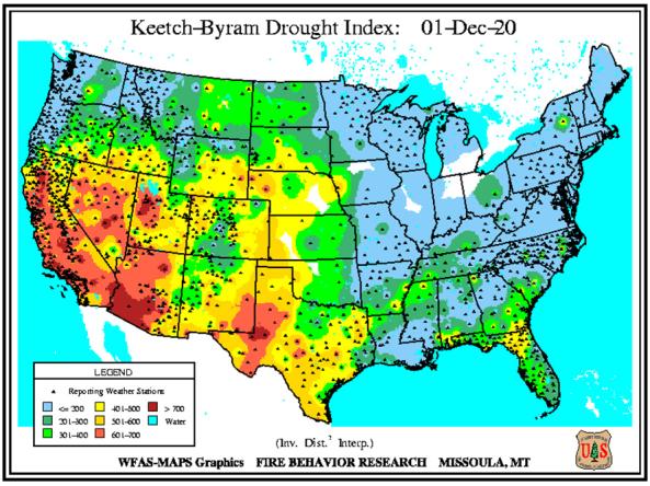
The Keetch-Byram Drought Index (KBDI) assesses the risk of fire by representing the net effect of evapotranspiration and precipitation in producing cumulative moisture deficiency in deep duff and upper soil layers.
The KBDI attempts to measure the amount of precipitation necessary to return the soil to full field capacity. The index ranges from zero, the point of no moisture deficiency, to 800, the maximum drought that is possible, and represents a moisture regime from 0 to 8 inches of water through the soil layer. At 8 inches of water, the KBDI assumes saturation. At any point along the scale, the index number indicates the amount of net rainfall that is required to reduce the index to zero, or saturation.
How to
What can I do with these data?
- View the amount of precipitation necessary to return the soil to full field capacity.
How do I use the site?
- Use your cursor to select between “Current Conditions” for the Contiguous U.S. or Alaska
- To save image: right-click image and select “Save Image As...”
- View archived maps for the Contiguous U.S., select “US48” under “Image Archive”
Access
Keetch-Byram Drought Index landing page
Archived Keetch-Byram Drought Index data: Download data for previous maps of the contiguous U.S.
Documentation
Bradshaw, Larry S.; Deeming, John E.; Burgan, Robert E.; Cohen, Jack D., compilers. 1984. The 1978 National Fire-Danger Rating System: technical documentation. Gen. Tech. Rep. INT-169. Ogden, UT: U.S. Department of Agriculture, Forest Service, Intermountain Forest and Range Experiment Station. 44 pp.
Burgan, R.E.; Andrews, P.L.; Bradshaw, L.S.; Chase, C.H.; Hartford, R.A.; Latham, D.J. 1997. WFAS: wildland fire assessment system, Fire Management Notes, 57(2):14-17; 1997.
Burgan, R.E.; Chase, C.H., Bartlette, R.A; NDVI and Derived Image Data, Data Archives 1998, 1999, USDA-FS, RMRS. RMRS-GTR-27-CD. 1999.
Burgan, R.E.; Hardy, C.C.; Ohlen, D.O.; Fosnight, G. 1997. Landcover Ground Sample Data. United States Department of Agriculture, Forest Service, General Technical Report INT-GTR-368CD. 1997.
Burgan, R.E.; Hardy, C.C.; Ohlen, D.O.; Fosnight, G.; Treder, R. 1999. Ground sample data for the national land cover characteristics database. United States Department of Agriculture, Forest Service, General Technical Report RMRS-GTR-41, Rocky Mountain Research Station,Ogden, Utah. 12 pages.
Burgan, R.E.; Hartford, R.A. 1993. Monitoring vegetation greenness with satellite data. United States Department of Agriculture, Forest Service, General Technical Report INT-297, Intermountain Forest and Range Experiment Station, Ogden, Utah. 13 pages.
Burgan, Robert E.; Hartford, Roberta A.; Eidenshink, Jeffery C. 1996. Using NDVI to assess departure from average greenness and its relation to fire business. Gen. Tech. Rep. INT-GTR-333. Ogden, UT:U.S. Department of Agriculture, Forest Service, Intermountain Research Station. 8 p.
Burgan, Robert E.; Hartford, Roberta A. 1997. Live vegetation moisture calculated from NDVI and used in fire danger rating. 13th Conf. on Fire and For. Met., Lorne, Australia, Oct. 27-31, 1997. Jason Greenlee, ed. IAWF, Fairfield, WA 99012.
Burgan, R.E., Klaver, R.W., Klaver, J.M. 1998. Fuel Models and Fire Potential from Satellite and Surface Observations. International Journal of Wildland Fire 8(3):159-170.
Burgan, Robert E. 1988. 1988 revisions to the 1978 National Fire-Danger Rating System. Res. Pap. SE-273. Asheville, NC: U.S. Department of Agriculture, Forest Service, Southeastern Forest Experiment Station. 39 pp.
Carlson, J.D.; Burgan, R.E.; Engle, D.M. 1996. Using the Oklahoma mesonet in developing a near-real- time, next generation fire danger rating system. In: 22nd Conference on Agricultural & Forest Meteorology with Symposium on Fire & Forest Meteorology and the 12th Conference on Biometeorology and Aerobiology, Atlanta, Georgia, January 28-February 2, 1996. American Meteorological Society, Boston, Massachusetts, Pages 249-252
Deeming, John E.; Burgan, Robert E.; Cohen, Jack D. 1977. The National Fire-Danger Rating System - 1978. Gen. Tech. Rep. INT-39. Ogden, UT: U.S. Department of Agriculture, Forest Service, Intermountain Forest and Range Experiment Station. 63 pp.
Fuquay Donald J. (1982), Positive Cloud-to-Ground Lightning in Summer Thunderstorms. J. Geophys. Res. 87., No. C9, 7131-7140
Haines, D.A. 1988. A lower atmospheric severity index for wildland fire. National Weather Digest. Vol 13. No. 2:23-27.
Hardy, C.C.; Menakis, J.P.; Schmidt, K.M.; Long, D.G.; Simmerman, D.G.; Johnston, C.M. 1999. Coarse-scale spatial data for Wildland Fire and Fuel Management. Rocky Mountain Research Station. Available at http://www.fs.fed.us/fire/fuelman/
Keetch, John J; Byram, George. 1968. A drought index for forest fire control. Res. Paper SE-38. Asheville, NC: U.S. Department of Agriculture, Forest Service, Southeastern Forest Experiment Station. 32 pp. (Revised 1988).
Latham, Don J.; Schlieter, Joyce A. 1989. Ignition probabilities of wildland fuels based on simulated lightning discharges. Res. Pap. INT-411. Ogden, UT: U.S. Department of Agriculture, Forest Service, Intermountain Research Station. 16 pp.
Loveland, T.R.; Merchant, J.W; Ohlen, D.O.; Brown, J.F. 1991. Development of a land-cover characteristics database for the conterminous U.S. Photogrammetric Engineering and Remote Sensing 57(11):1453-1463.
Loveland, T.R.; Ohlen, D.O.; Brown, J.F.; Reed, B.C.; Zhu, Z.; Merchant, J.W.; Yang, L. In press. Western hemisphere land cover-progress toward a global land cover characteristics database, In: Proceedings, Pecora 13, Human Interventions with the Environment: Perspectives From Space.
McCutchan, Morris H.; Meisner, Bernard N.; Fujioka, Francis M.; Benoit, John W. and Ly, Benjamin B. 1991. Monthly Fire Weather Forecasts. Fire Management Notes. 52(3):41-47
Palmer, W. C., 1965. Meteorological Drought. Research Paper No. 45, U.S. Department of Commerce Weather Bureau, Washington, D.C.
USDA Forest Service. 1995. Weather Information Management System User's Guide. Washington, DC: U.S. Department of Agriculture, Forest Service, Fire and Aviation Management.


