Paleoclimate
Paleoclimatologists study environmental evidence to understand what the Earth’s past climate was like and why. They use proxy climate records to estimate past conditions and extend our understanding of climate that existed long ago.
What Is a Paleoclimate?
According to the AMS Glossary of Meteorology, a paleoclimate is the “climate for periods prior to the development of measuring instruments, including historic and geologic time, for which only proxy climate records are available.” Examples of proxy climate records include historical documents and data preserved within corals, pollen grains, ice cores, tree rings, and ocean and lake sediments.
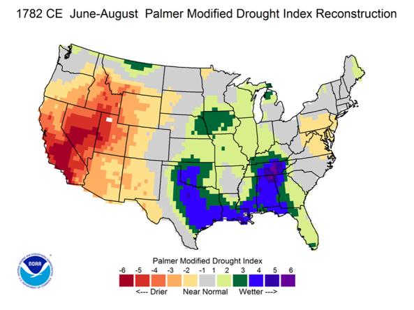
This map shows the number of summers from 1400 to 2017 with moderate to extreme drought, based on the Living Blended Drought Atlas (LBDA). While the dataset extends to year 0 in some locations, full coverage of the lower 48 U.S. states is not available until 1400. The LBDA is a recalibrated data series of June-July-August Palmer Modified Drought Index (PMDI) values in the lower 48 U.S. states, blending tree-ring reconstructions and instrumental data to estimate the average summer PMDI values.
A drought index combines multiple drought indicators (e.g., precipitation, temperature, soil moisture) to depict drought conditions. For some products, like the U.S. Drought Monitor, authors combine their analysis of drought indicators with input from local observers. Other drought indices, like the Standardized Precipitation Index (SPI), use an objective calculation to describe the severity, location, timing, and/or duration of drought.
Learn MoreDrought is defined as the lack of precipitation over an extended period of time, usually for a season or more, that results in a water shortage. Changes in precipitation can substantially disrupt crops and livestock, influence the frequency and intensity of severe weather events, and affect the quality and quantity of water available for municipal and industrial use.
Learn MoreAir temperature can have wide-ranging effects on natural processes. Warmer air temperatures increase evapotranspiration—which is the combination of evaporation from the soil and bodies of water and transpiration from plants—and lower soil moisture.
Learn MoreDrought can reduce the water availability and water quality necessary for productive farms, ranches, and grazing lands, resulting in significant negative direct and indirect economic impacts to the agricultural sector. Monitoring agricultural drought typically focuses on examining levels of precipitation, evaporative demand, soil moisture, and surface/groundwater quantity and quality.
Learn MoreNumber of Summers in Drought
This map shows the number of summers from 1400 to 2017 with moderate to extreme drought, based on the Living Blended Drought Atlas (LBDA). While the dataset extends to year 0 in some locations, full coverage of the lower 48 U.S. states is not available until 1400. The LBDA is a recalibrated data series of June-July-August Palmer Modified Drought Index (PMDI) values in the lower 48 U.S. states, blending tree-ring reconstructions and instrumental data to estimate the average summer PMDI values.
This dataset, from the Living Blended Drought Atlas, uses tree-ring reconstructions and instrumental data to estimate the Palmer Modified Drought Index for each June–August, from 0–2017. This map includes data from 1400–2017.
A drought index combines multiple drought indicators (e.g., precipitation, temperature, soil moisture) to depict drought conditions. For some products, like the U.S. Drought Monitor, authors combine their analysis of drought indicators with input from local observers. Other drought indices, like the Standardized Precipitation Index (SPI), use an objective calculation to describe the severity, location, timing, and/or duration of drought.
Learn MoreDrought is defined as the lack of precipitation over an extended period of time, usually for a season or more, that results in a water shortage. Changes in precipitation can substantially disrupt crops and livestock, influence the frequency and intensity of severe weather events, and affect the quality and quantity of water available for municipal and industrial use.
Learn MoreAir temperature can have wide-ranging effects on natural processes. Warmer air temperatures increase evapotranspiration—which is the combination of evaporation from the soil and bodies of water and transpiration from plants—and lower soil moisture.
Learn MoreDrought can reduce the water availability and water quality necessary for productive farms, ranches, and grazing lands, resulting in significant negative direct and indirect economic impacts to the agricultural sector. Monitoring agricultural drought typically focuses on examining levels of precipitation, evaporative demand, soil moisture, and surface/groundwater quantity and quality.
Learn MoreData and Map Gallery
One of the limits of climatology is that we only have about a hundred years of instrumentally gathered weather data, and we know that they don’t give us the full story. The natural world has recorded its own stories in tree rings, lake sediments, ice, cave deposits, and fossils, and paleoclimatologists put that information together to assemble thousands of years of climate history. Paleoclimatology helps us understand the full range of natural variability.
Use these resources to find information about paleoclimatology and access geophysical and biological paleoclimatology datasets and historical drought information.
The Living Blended Drought Atlas (LBDA) is a recalibrated data series of June-July-August Palmer Modified Drought Index (PMDI) values by United States climate division, compiled by blending tree-ri
The OWDA provides new data to determine the causes of Old World drought and wetness and attribute past climate variability to forced and/or internal variability.
NCEI provides the paleoclimatology data and information scientists need to understand natural climate variability and future climate change.
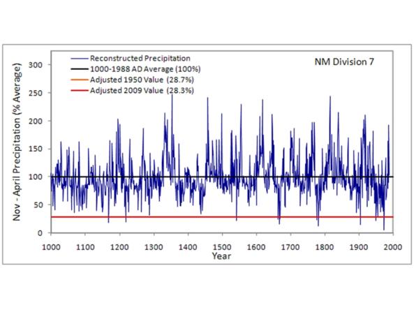
This CLIMAS Southwest Paleoclimate Tool provides detailed paleoclimate information for Arizona and New Mexico.
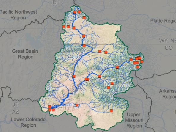
Selected research papers, reports, and other resources which show the current state-of-knowledge and the progress in our understanding of the variability of climate and hydrology in the Colorado Ri
Paleoclimatology and Historical Drought
Megadroughts
Tree-ring and lake-sediment records indicate that "megadroughts" have occurred in North America over the last thousand years. According to those proxy records, it appears that those persistent droughts lasted longer than droughts experienced since we’ve had instrumental records.
Variability
Earth’s climate is variable and always changing. For example, during the past two million years much of the northern hemisphere has been covered in glacial ice with sea levels lower by as much as 410 feet during glacial periods. In contrast, the Cretaceous Period (between 145.5 and 65.5 million years ago) saw conditions that were significantly warmer than today, with less polar ice and rising sea levels.
Research & Learn | Historical Drought
Drought is a normal climate pattern that has occurred in varying degrees of length, severity, and size throughout history. Learn more about historical drought.
Data & Maps | Historical Data and Conditions
View a collection of historical drought conditions for the U.S., including statistics, map and data archives, and time series. Explore three historical drought datasets side by side on an interactive map.
Paleoclimatology Research and Resources
Web Resources
NASA | Earth Observatory | Paleoclimatology Introduction
An examination of how scientists reconstruct the history of Earth’s climate over hundreds of thousands—in some cases millions—of years.
NOAA | National Centers for Environmental Information | Paleoclimatology Education & Outreach
Educational resources about paleoclimatology from NOAA's National Centers for Environmental Information (NCEI).
U.S. Geological Survey | Paleoclimate
Learn more about paleoclimate science and explore paleoclimate research from USGS's Land Change Science Program.


