
Northeast
The Northeast DEWS consists of the New England states and the state of New York. Known best for its autumn foliage, thick forests, rocky soils, and abundant freshwater resources, the northeastern United States is characterized by a diverse climate that is not often associated with drought. However, in 2000, 2016, 2020, and 2022, New York and New England experienced historic drought conditions not seen since the 1960s. The Northeast also frequently experiences “flash” droughts—the rapid onset of intense dry periods that can follow a period of normal to above-normal precipitation. While these flash droughts may last only 2–6 months, they can have profound impacts in the region, resulting in agricultural losses, shortages in public water supplies, and very low streamflows. The Northeast DEWS is a collaborative federal, regional, state, and local interagency effort to improve drought early warning capacity and build long-term drought resilience. View conditions & forecasts on the Northeast DEWS Dashboard.
Primary contact: Rocky Bilotta, Regional Drought Information Coordinator
Regional Activities
The following table highlights activities in the Northeast that are ongoing efforts related to drought, involve multiple partners, serve as a unique way to address regional drought needs, and are related to at least one of the components of drought early warning. Please contact Crystal Stiles for more information about the table or to inquire about getting an activity added to the list.
DEWS Component Legend
In 2020, the Northeast DEWS team held listening sessions among its partners and stakeholders in New York and New England. The focus of the sessions was to identify action items that…
2022
2026
The purpose of this project was to increase the dissemination of available drought-related information to end-user organizations in a way that allows them to develop a multi-seasonal drought…
Assessments following the 2016 drought in New York and New England broadly identified data gaps related to soil moisture, streamflow, and groundwater levels. To address these shortcomings, this…
2019
2021
This objective of this project, led by researchers from the Desert Research Institute, University of Colorado, and Cornell University, was to identify the most effective drought…
2019
2021
National Weather Service drought information statements provide up-to-date reports on the current drought situation for a Weather Forecast Office’s (WFO's) county warning and forecast area. These…
Observation + Monitoring
When monitoring drought, it is important to look at data across the spectrum—from the atmosphere, land surface, and water availability below the surface. The list of data and maps below has been customized for the Northeast, and provides a snapshot of conditions across that spectrum—including precipitation and temperature data, streamflow, condition monitoring, and various derived indices for monitoring drought in the region.
Regional Data and Maps
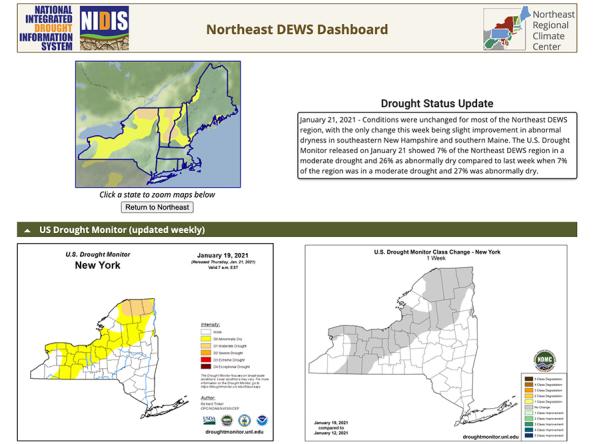
The Northeast Drought Early Warning System (DEWS) Dashboard, hosted by the Northeast Regional Climate Center, displays current drought status, impacts, and future conditions for the North
The U.S. Drought Monitor is a map updated each Thursday to show the location and intensity of drought across the country.
HPRCC produces daily climate maps using data from the Applied Climate Information System (ACIS). The maps and data can be accessed and downloaded from the HPRCC website.
The National Weather Service's National Water Prediction Service (NWPS) provides short-term observed and climatic trends of precipitation across the lower 48 United States (CONUS), Puerto Ric
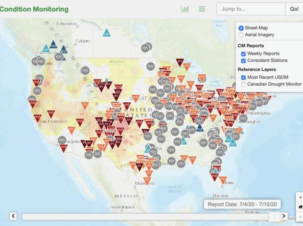
This condition monitoring map is a tool intended to depict local, community-level conditions and how recent weather and climate events have affected those communities.
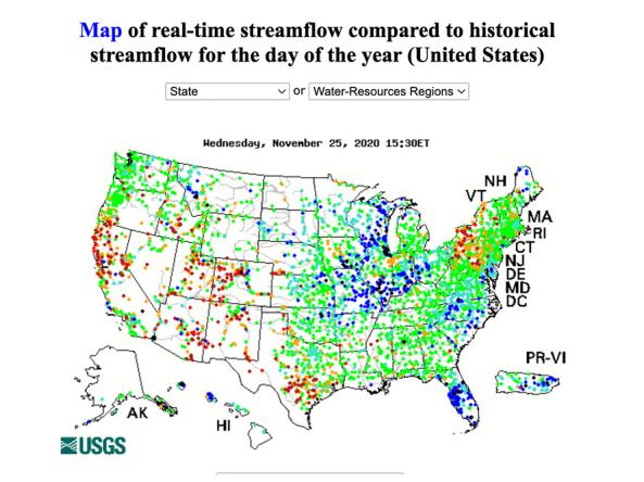
WaterWatch is a U.S. Geological Survey (USGS) World Wide Web site that displays maps, graphs, and tables describing real-time, recent, and past streamflow conditions for the United States.
Planning + Preparedness
There is little that can be done to influence the weather patterns that cause drought, but preparatory actions and policies can help communities cope with drought impacts. Drought planning can ensure continuity of public services and quality of life. Drought planning can be done at the local and/or state level, or integrated into existing plans (e.g., hazard mitigation planning, land-use planning).
Regional Drought Planning Resources


Prediction + Forecasting
When will drought affect me? How long could it last? This section includes resources for drought prediction and forecasting on what could be ahead, including the short-term (e.g., 8-14 day forecast), seasonal to subseasonal (e.g., monthly) and future climate projections (e.g., mid-century). The appropriate time scale will depend upon how this information is being used (e.g., drought response, mitigation management action, long-term planning). Weather and climate prediction is an evolving science, as researchers continue to find ways to improve models and forecasting capabilities at various time scales.
Regional Forecasts and Outlooks
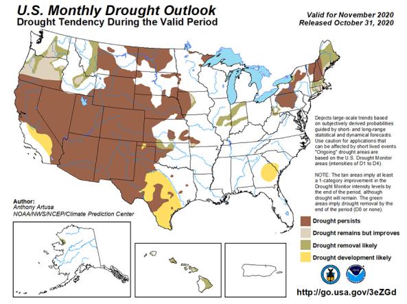
The U.S. Monthly Drought Outlook predicts whether drought will emerge, stay the same or get better over the next 30 days or so.
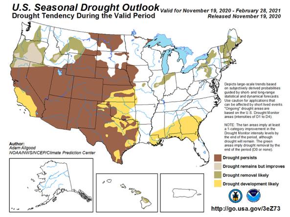
The U.S. Seasonal Drought Outlook depicts large-scale trends based on subjectively derived probabilities guided by short- and long-range statistical and dynamical forecasts.

The National Weather Service (NWS) Climate Prediction Center (CPC) produces monthly and seasonal drought outlooks based on Soil Moisture (CAS).
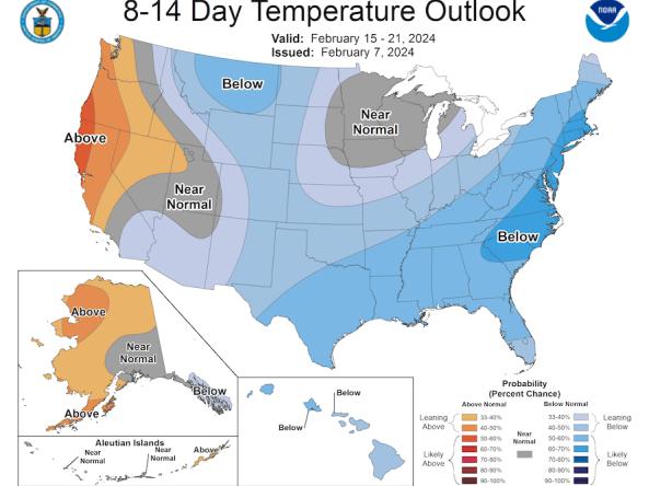
The Climate Prediction Center (CPC) produces temperature and precipitation outlooks for the U.S., including 6-10 day, 8-14 day, monthly, and seasonal outlooks.
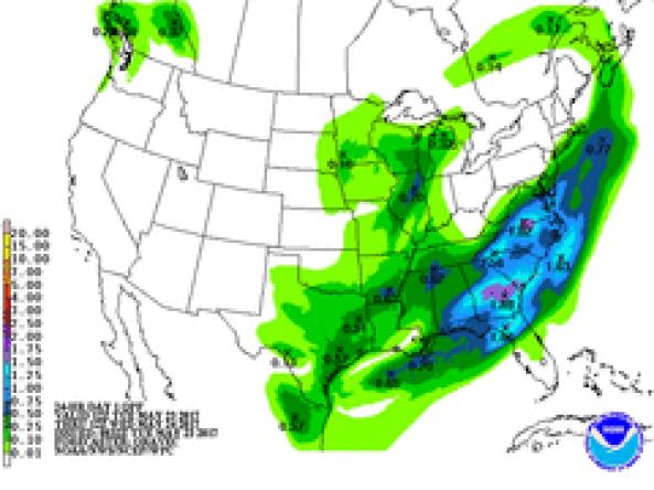
NWS WPC produces Quantitative Precipitation Forecasts (QPFs) that depict the amount of liquid precipitation expected to fall in a defined period of time.
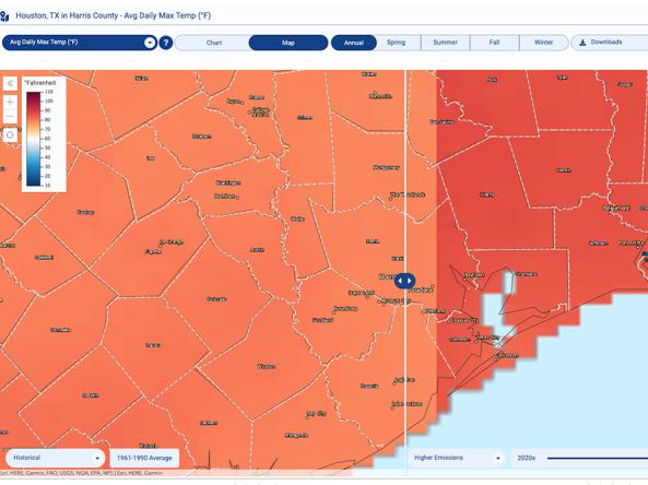
The Climate Explorer offers graphs and maps of observed and projected temperature, precipitation, and related climate variables for every county in the contiguous United States, helping people asse
Communication + Outreach
An important component for drought early warning is communicating this information to stakeholders across the Northeast region that need this information in order to make more informed decisions. There are various ways drought information is communicated across the Northeast, including a quarterly climate report, the Northeast DEWS email list, and a monthly climate update webinar series hosted by the Northeast Regional Climate Center (NRCC) and NOAA. For more information, contact Sylvia Reeves (sylvia.reeves@noaa.gov).
Regional Communications Documents


Research + Applications
Research to better understand drought in the Northeast and its development, persistence, improvement, and interaction with other hazards is critical to providing timely and reliable information, products, and services in support of early warning. Below are featured research projects that are studying drought in the Northeast region, with support from NIDIS.