Drought Developed Rapidly this Summer Despite a Wet Spring
Key Points
- After a very wet spring, the summer has been extremely dry and very warm. Since the beginning of August, drought developed and intensified in coastal Maine, and developed in other areas of Maine, New Hampshire, Vermont, and New York.
- Streamflows are running much below normal throughout the Northeast, especially across central and southern Maine, much of New Hampshire and Vermont, northern New York and Massachusetts, and coastal areas of Connecticut and Rhode Island. Groundwater levels are lowest in coastal areas of Maine and western New York.
- Drought impacts are occurring across the region, including crop and tree stress, dry wells, an increase in wildfire activity, and water restrictions.
- Below-normal temperatures and precipitation are expected in the next 8-14 days. Over the next three months, above-normal temperatures are favored with equal chances for above-, below-, and near-normal precipitation. Drought conditions are expected to improve or be removed this fall.
This U.S. Drought Monitor 4-week change map shows where drought and dryness have improved, remained the same, or worsened in the Northeast from July 22–August 19, 2025.
The U.S. Drought Monitor depicts the location and intensity of drought across the country, using 5 classifications (D0–D4). Green hues show where conditions improved, yellow/orange hues show where conditions worsened, and gray areas show where drought remained the same.
A drought index combines multiple drought indicators (e.g., precipitation, temperature, soil moisture) to depict drought conditions. For some products, like the U.S. Drought Monitor, authors combine their analysis of drought indicators with input from local observers. Other drought indices, like the Standardized Precipitation Index (SPI), use an objective calculation to describe the severity, location, timing, and/or duration of drought.
Learn MorePeriods of drought can lead to inadequate water supply, threatening the health, safety, and welfare of communities. Streamflow, groundwater, reservoir, and snowpack data are key to monitoring and forecasting water supply.
Learn MoreDrought can reduce the water availability and water quality necessary for productive farms, ranches, and grazing lands, resulting in significant negative direct and indirect economic impacts to the agricultural sector. Monitoring agricultural drought typically focuses on examining levels of precipitation, evaporative demand, soil moisture, and surface/groundwater quantity and quality.
Learn MoreDrought Degradation
5-Category Degradation
Drought/dryness has worsened by 5 categories, according to the U.S. Drought Monitor.
4-Category Degradation
Drought/dryness has worsened by 4 categories, according to the U.S. Drought Monitor.
3-Category Degradation
Drought/dryness has worsened by 3 categories, according to the U.S. Drought Monitor.
2-Category Degradation
Drought/dryness has worsened by 2 categories, according to the U.S. Drought Monitor.
1-Category Degradation
Drought/dryness has worsened by 1 category, according to the U.S. Drought Monitor.
Drought Improvement
1-Category Improvement
Drought/dryness has improved by 1 category, according to the U.S. Drought Monitor.
2-Category Improvement
Drought/dryness has improved by 2 categories, according to the U.S. Drought Monitor.
3-Category Improvement
Drought/dryness has improved by 3 categories, according to the U.S. Drought Monitor.
4-Category Improvement
Drought/dryness has improved by 4 categories, according to the U.S. Drought Monitor.
5-Category Improvement
Drought/dryness has improved by 5 categories, according to the U.S. Drought Monitor.
This U.S. Drought Monitor 4-week change map shows where drought and dryness have improved, remained the same, or worsened in the Northeast from July 22–August 19, 2025.
The U.S. Drought Monitor depicts the location and intensity of drought across the country, using 5 classifications (D0–D4). Green hues show where conditions improved, yellow/orange hues show where conditions worsened, and gray areas show where drought remained the same.
This U.S. Drought Monitor and change maps are released every Thursday morning, with data valid through Tuesday at 7 a.m. EST.
A drought index combines multiple drought indicators (e.g., precipitation, temperature, soil moisture) to depict drought conditions. For some products, like the U.S. Drought Monitor, authors combine their analysis of drought indicators with input from local observers. Other drought indices, like the Standardized Precipitation Index (SPI), use an objective calculation to describe the severity, location, timing, and/or duration of drought.
Learn MorePeriods of drought can lead to inadequate water supply, threatening the health, safety, and welfare of communities. Streamflow, groundwater, reservoir, and snowpack data are key to monitoring and forecasting water supply.
Learn MoreDrought can reduce the water availability and water quality necessary for productive farms, ranches, and grazing lands, resulting in significant negative direct and indirect economic impacts to the agricultural sector. Monitoring agricultural drought typically focuses on examining levels of precipitation, evaporative demand, soil moisture, and surface/groundwater quantity and quality.
Learn MoreThis update is based on data available as of Thursday, August 21, 2025 at 10 a.m. ET. We acknowledge that conditions are evolving.
Current Conditions in the Northeast
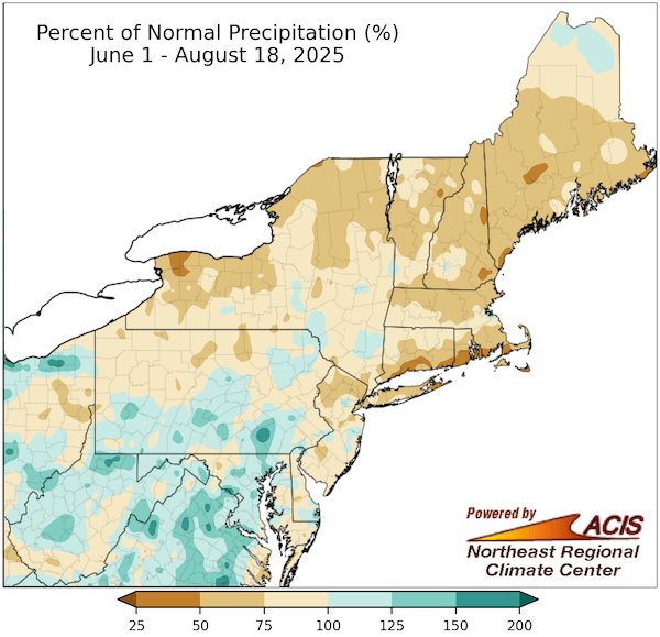
- Warm and dry conditions have largely dominated in the Northeast since the beginning of June. The driest areas only received 25-75% of normal precipitation, while temperatures since June 1 ranged from 2-4°F above normal.
- Since the beginning of August, Moderate Drought (D1) developed across southern and coastal areas of Maine, much of New Hampshire, central Vermont, western New York, and New York City. In the past week, Severe Drought (D2) was introduced to coastal Maine. Moderate Drought (D1) on Nantucket and Cape Cod in Massachusetts has been present since February and April, respectively.
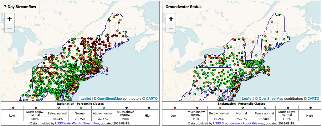
- Streamflows have significantly declined throughout the region, with many gages reporting flows below the 10th percentile. As of August 19, Otter Creek near Bar Harbor, Maine was reporting flows of only 0.07 cubic feet per second, which was the lowest flow reported at this location since 2020.
- Low streamflows and persistently below-normal groundwater levels caused wells to go dry and prompted water restrictions. The South Berwick Water District in Maine issued a water emergency declaration due to long-term dry conditions and high heat. In New York, water conservation measures were strongly encouraged for Suffolk County (Long Island). Cape Cod has contended with groundwater issues since last year; groundwater at the Sandwich, Massachusetts U.S. Geological Survey (USGS) observation well has steadily declined since September 2024.
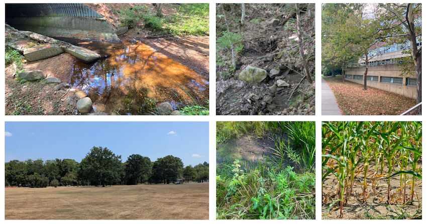
- Depleted soil moisture and high evaporative demand dried out vegetation and increased fire danger, contributing to an increase in wildfire activity in Maine, New Hampshire, and Vermont. County officials issued burn bans in parts of New York and Vermont, and the Maine Forest Service temporarily suspended the issuance of new burn permits.
- The heat and dryness have also impacted agriculture. Reports include rolled and spiky corn leaves, flipped soybean leaves, dry hay fields, apples discoloring and dropping early from trees, and low irrigation supply for corn and blueberries.
Below-Normal Precipitation Has Dominated the Northeast Since June
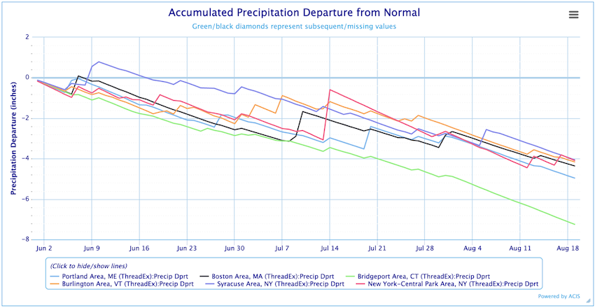
Negative Precipitation Departures Have Mounted Quickly
Streamflow and Groundwater Levels Are Below Normal in Many Locations
Drought Impacts Are Apparent throughout the Northeast
Outlooks and Potential Impacts for the Northeast
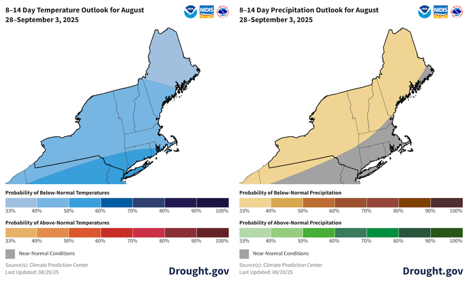
- The Climate Prediction Center’s 8-14 day outlook favors below-normal temperatures for the region, and precipitation is expected to be below normal for Vermont, most of New Hampshire and Maine, and northern and central New York. The monthly outlook for September and the three-month outlook for September-November both favor above-normal temperatures and equal chances of above-, below-, and near-normal precipitation for the entire region.
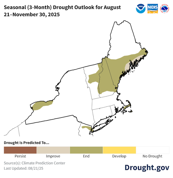
- The Climate Prediction Center’s seasonal drought outlook for August 21–November 30 favors drought removal for New York, Massachusetts, Vermont, New Hampshire, and southern and eastern parts of Maine. Drought is forecast to remain but improve in coastal areas of Maine.
- Reduced yields of corn and soybeans in drought-stricken areas are becoming more likely. In Vermont, producers are concerned dry pastures will force them to supplement feed for livestock.
- Fire danger is expected to remain elevated while drought conditions persist. Monitor conditions and updates from state and local officials.
- Streamflows and groundwater levels will continue to drop with ongoing dry conditions. Follow local officials for information on water restrictions or conservation measures.
- Increased reports of leaf drop indicate that fall color and recreational leaf peeping may be negatively impacted this fall.
8-14 Day Outlook Favors Cool and Dry Conditions
Drought Improvement and Removal Expected This Fall
Additional Resources
- Northeast DEWS Dashboard
- Weekly Northeast Drought Update from the Northeast Regional Climate Center
- The next Northeast Regional Climate Center monthly webinar is Thursday, August 28 at 9:30 a.m. ET. Register here.
- Connecticut Drought Information Center
- Maine Drought Task Force Dry Well Survey
- Massachusetts Drought Status
- New York Department of Environmental Conservation Current Drought Conditions
- Rhode Island State Climate Office Weekly Drought Discussion
- Rhode Island Water Resources Board Drought Monitoring Dashboard
- Vermont Agency of Natural Resources Current Fire Danger Forecast
- Vermont Drinking Water Drought Reporter
- View or submit Condition Monitoring Observer Reports (CMOR)
Prepared By
Crystal Stiles
Cooperative Institute for Research in Environmental Sciences (CIRES) at the University of Colorado Boulder | NOAA National Integrated Drought Information System (NIDIS)
Samantha Borisoff, Art DeGaetano, Keith Eggleston, Jessica Spaccio, Natalie Umphlett
Northeast Regional Climate Center
A special thank you to the state climate offices and National Weather Service offices in the Northeast region for providing local information on drought conditions and impacts included in this Drought Status Update.
This Drought Status Update is issued in partnership between the National Oceanic and Atmospheric Administration (NOAA), the Northeast Regional Climate Center, the U.S. Geological Survey, and State Climatologists to communicate a potential area of concern for drought expansion and/or development within the Northeast region based on recent conditions and the upcoming forecast. NIDIS and its partners will issue future Drought Status Updates as conditions evolve.
