National Weather Service Drought Information Statements
National Oceanic and Atmospheric Administration (NOAA) National Weather Service (NWS) Weather Forecast Offices
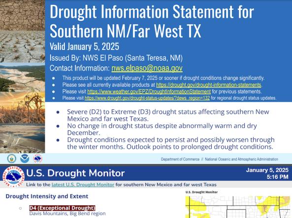
National Weather Service drought information statements provide up-to-date reports on the current drought situation for a Weather Forecast Office’s (WFO's) county warning and forecast area. These statements are text-based products that summarize recent weather and hydrologic conditions, discuss local drought impacts, and provide a local drought outlook.
WFOs may issue a drought information statement when the U.S. Drought Monitor indicates a drought intensity of Extreme Drought (D3) or greater in any portion of the WFO county warning and forecast area. These statements may also be issued when Moderate to Severe Drought (D1 or D2) designations are present or when drought impacts have been reported in the local area.
Drought information statements were ingested from the various National Weather Service Weather Forecast Offices (WFO). WFOs with statements published within the past 35 days are joined with spatial data for visualization purposes. U.S. Drought Monitor data from the National Drought Mitigation Center were available in a GIS format.
Click on the "i" icon to view more information.
Drought Information Statements
U.S. Drought Monitor
D0 - Abnormally Dry
Abnormally Dry (D0) indicates a region that is going into or coming out of drought, according to the U.S. Drought Monitor. View typical impacts by state.
D1 – Moderate Drought
Moderate Drought (D1) is the first of four drought categories (D1–D4), according to the U.S. Drought Monitor. View typical impacts by state.
D2 – Severe Drought
Severe Drought (D2) is the second of four drought categories (D1–D4), according to the U.S. Drought Monitor. View typical impacts by state.
D3 – Extreme Drought
Extreme Drought (D3) is the third of four drought categories (D1–D4), according to the U.S. Drought Monitor. View typical impacts by state.
D4 – Exceptional Drought
Exceptional Drought (D4) is the most intense drought category, according to the U.S. Drought Monitor. View typical impacts by state.
Drought information statements were ingested from the various National Weather Service Weather Forecast Offices (WFO). WFOs with statements published within the past 35 days are joined with spatial data for visualization purposes. U.S. Drought Monitor data from the National Drought Mitigation Center were available in a GIS format.
Click on the "i" icon to view more information.
Access
Drought Information Statement Interactive Map: Access an interactive map of all drought information statements from the past 35 days on Drought.gov
NWS Weather Forecast Offices: Select a Weather Forecast Office website to view any drought information statements for that region.