Citizen Scientists: Help Monitor Drought by Reporting Observations

On September 11, 2017, the Community Collaborative Rain, Hail, and Snow (CoCoRaHS) network is launching new materials for the national network of condition monitoring observers, who are providing on-the-ground impacts information to support drought monitoring and reporting.
As part of the NIDIS-supported Coastal Carolinas Drought Early Warning System, the Carolinas Integrated Sciences & Assessments (CISA) team began a pilot project in 2013 to assess how citizen scientists might contribute to drought impacts monitoring and reporting. Using tools developed by CoCoRaHS, CISA recruited volunteers to submit weekly condition monitoring reports. These regular reports are intended to capture the effects of rainfall, or a lack thereof, on an observer’s local environment and community. Regular reporting also supports documentation of impacts related to the onset, intensification, and recovery of drought conditions.
Building on a successful pilot program in the Carolinas, CoCoRaHS released the condition monitoring report form to its national network of more than 20,000 volunteers in October 2016. Since that time, over 12,000 reports have been submitted from observers throughout the US. In order to improve access and usability of the reports, the CISA team developed a condition monitoring web map. The web map allows users to view individual condition monitoring reports spatially and in conjunction with other contextual information, such as the US Drought Monitor Map. CoCoRaHS has also created a new webpage to provide summary charts which display information provided in condition monitoring reports to document changing on-the-ground conditions over time.
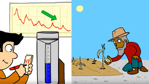
New training materials will also be released on Monday, to encourage more CoCoRaHS observers to contribute to the program. A training animation introduces the idea behind condition monitoring, provides instructions on how to file a report, and demonstrates why it’s important to monitor local conditions to help document local conditions. A new slideshow tutorial includes these same components as well as information about how to access and use the web map and the summary charts.
The project team hopes that condition monitoring reports will serve as useful information for drought monitoring and impacts reporting by supporting a network of citizen scientists who are able to share their local knowledge and expertise.


