Using Soil Moisture Information to Better Understand and Predict Wildfire Danger
Key Points:
- Greater use of soil moisture information in fire danger rating systems could lead to earlier warning of wildfire danger, and better forecasts of wildfire occurrence and size.
- Soil moisture data sources are increasingly available at temporal and spatial scales needed to support fire danger assessment, including in situ and remotely-sensed datasets as well as data derived from improved land surface modeling.
- Findings from diverse ecosystems and geographies highlight the dependencies of fuel loads, fuel moisture content, and wildfire probability on soil moisture.
- Soil moisture has been found to be a strong predictor of live fuel moisture, and more recently of dead fuel moisture of forest litter.
- Although the relationships between soil moisture levels and live and dead fuel moisture and fuel loads can vary by ecological type (e.g., forests versus grasslands), researchers have made strides in characterizing these differences.
- Because current soil moisture conditions can influence future fuel load, soil moisture observations may be particularly helpful in providing forecasts of wildfire danger.
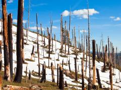
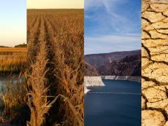
Determining and managing wildland fire risk—in both forests and grasslands—is becoming increasingly important across the U.S and around the world. Not only are climate change-induced drought conditions making wildfires more likely in many places, but increasing human settlement along the urban-wildland interface can make impacts more severe. These factors put a premium on developing improved prediction capabilities for wildland fire.
A recent international review article, Using soil moisture information to better understand and predict wildfire danger: A review of recent developments and outstanding questions, summarizes the growing body of evidence indicating that greater use of soil moisture information in fire danger rating systems could lead to better estimates of dynamic live and dead herbaceous fuel loads, more accurate live and dead fuel moisture predictions, earlier warning of wildfire danger, and better forecasts of wildfire occurrence and size.
The article reviews the increasing availability of soil moisture data from in situ, remotely-sensed, and modeled sources, and provides a comprehensive summary of international research on the relationships between wildfire/fuel bed properties and each type of soil moisture information. The article documents a series of findings from diverse ecosystems and geographies that highlight the dependencies of fuel loads, fuel moisture content, and wildfire probability on soil moisture. For example, soil moisture has been found to be a strong predictor of live fuel moisture, and in some ecosystems, dead fuel moisture. Although the relationships between soil moisture levels and live and dead fuel moisture and fuel loads can vary by ecological type (e.g., forests versus grasslands), the article documents ways in which researchers have made strides in characterizing these differences.
The article then highlights potential opportunities to apply soil moisture information to existing fire danger rating systems, using the U.S. National Fire Danger Rating System (NFDRS) as a case study. The article concludes by describing primary challenges and opportunities for using soil moisture information to better understand and predict wildfire danger. It identifies key areas of needed future research, including such topics as: What representations of soil moisture (e.g., absolute values, anomalies, etc.) are best suited to wildfire danger assessment? How can soil moisture information be used to produce accurate dynamic estimates of live and dead fuel loads? And how do pre-fire soil moisture conditions influence burn severity, soil heating, and post-fire impacts? As a result, the article provides a clear “research-to-action” road map for improving wildland fire prediction and management.
This review article arose in part as an outcome of the symposium “Using Soil Moisture Information to Better Understand and Predict Wildfire Danger: A Symposium for Researchers and Fire Managers,” held in May 2021 and sponsored by the U.S. Geological Survey South Central Climate Adaptation Science Center, with additional programmatic support provided by the U.S. Forest Service, the National Coordinated Soil Moisture Monitoring Network, and NIDIS.