Colorado River Drought Contingency Plan
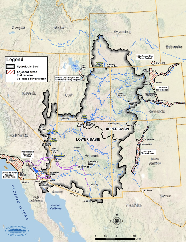
The Colorado River provides water to almost 40 million people in two countries, seven states, 29 federally recognized Indian tribes, and 4 million acres of farmland. Since 2000, historically dry conditions have added stress to the Colorado River’s water resources. As a result, the risk of reaching critically low elevations at Lakes Powell and Mead has increased nearly four-fold over the past decade. Critically low reservoir levels could affect compliance with the 1922 Colorado River Compact; Lake Powell could drop below the level required to generate hydropower; and the economies, livelihoods, cultural and religious activities, ecological systems and natural resources of communities in the basin could be negatively impacted.
To reduce the risk of Lake Powell and Lake Mead declining to critically low levels, in December 2017, the U.S. Department of the Interior called on the seven Colorado River Basin States of Wyoming, Colorado, Utah, New Mexico, Arizona, California, and Nevada to put drought contingency plans in place before the end of 2018.
The Colorado River Drought Contingency Plan was submitted to Congress by the states of Arizona, California, Colorado, Nevada, New Mexico, Utah, and Wyoming on March 19, 2019. On April 16, 2019, the Colorado River Drought Contingency Plan Authorization Act was signed into law. This bill requires the Department of the Interior to execute the Colorado River Drought Contingency Plan without delay and operate applicable Colorado River System reservoirs accordingly.
On May 20, 2019, the Secretary of the Interior and the Upper Colorado River Division States of Colorado, New Mexico, Utah, and Wyoming, the State of Arizona, the Metropolitan Water District of Southern California, the Coachella Valley Water District, the Palo Verde Irrigation District, the City of Needles, the Colorado River Commission of Nevada, and the Southern Nevada Water Authority executed a Companion Agreement concerning Colorado River Drought Contingency Management and Operations.
How Is NIDIS Supporting the Colorado River Basin States?
Together with federal, state, local, tribal, and private-sector partners, NIDIS coordinates and integrates drought research, building upon existing federal, tribal, state, and local partnerships in support of creating a national drought early warning information system. Examples of NIDIS support for tribal partners and Colorado River Basin states’ drought early warning, planning, and mitigation efforts can be found below:
Additional Resources
Web Resources
Story Map: Drought in the Colorado River Basin
U.S. Geological Survey and U.S. Bureau of Reclamation
Story Map: The Hardest Working River in the West
Babbitt Center for Land and Water Policy, the Lincoln Institute of Land Policy
Colorado River Basin Drought Contingency Plans
U.S. Bureau of Reclamation
Colorado River Water Supply and Demand Study
U.S. Bureau of Reclamation
The Ten Tribes Partnership for the Colorado River
The Ten Tribes Partnership
Colorado River Basin Ten Tribes Partnership Water Study
U.S. Bureau of Reclamation and The Ten Tribes Partnership
Water & Tribes Initiative/Colorado River Basin
University of Montana, Center for Natural Resources & Environmental Policy
Upper Colorado River Commission
Upper Colorado River Commission
Layperson’s Guide to the Colorado River
Water Education Foundation
Data & Maps
Glen Canyon Dam: Lake Powell Data and Information
U.S. Bureau of Reclamation
Water in Lake Powell: NASA Landsat Satellite Imagery
NASA Earth Observatory
Hoover Dam: Lake Mead Data and Information
U.S. Bureau of Reclamation