Site Section
Data & Maps
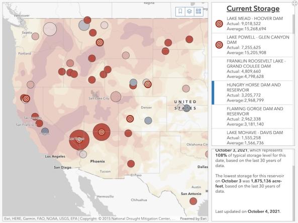
Reclamation Reservoir Storage Dashboard
Associated Agencies
U.S. Department of the Interior (DOI) Bureau of Reclamation
The U.S. Bureau of Reclamation's interactive Reservoir Storage Dashboard provides current conditions for 44 major Reclamation reservoirs and comparisons with historical storage data. For each reservoir, users can view the current storage amount in acre-feet, the current storage level as a percent of average (based on the last 30 years of data), and records for lowest observed storage.
Access
Reservoir Storage Dashboard: Interactive map with storage levels for 44 major Reclamation reservoirs across the West
Reservoir Teacup Diagram: Teacup diagrams for several major Reclamation reservoirs, showing current reservoir storage compared to average
How To
- Select a reservoir on the interactive map or from the list in the right sidebar to view current reservoir storage as a percent of average, total reservoir storage in acre-feet, and historically low storage conditions for that reservoir.
- Select a state from the dropdown to view major Reclamation reservoirs for that state.
- Select the layers icon in the top right corner to view or hide three map layers: daily reservoir levels, flags for record lowest observed storage in 30 years, and current drought conditions from the U.S. Drought Monitor.
Partner(s)
Representative Image