Fire Information for Resource Management System (FIRMS) US/Canada
National Aeronautic and Space Administration (NASA), U.S. Forest Service
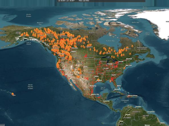
The Fire Information for Resource Management System (FIRMS) US/Canada is a joint effort by NASA and the U.S. Forest Service to provide access to low latency satellite imagery and science data products from earth observation system satellite assets to identify the location, extent, and intensity of wildfire activity and its effects.
FIRMS US/Canada tools and applications provide geospatial data, products, and services to support strategic fire management needs of U.S. and Canadian agencies and inform the general public.
FIRMS US/Canada is enabled by data and applications provided by NASA’s Earth Observing System Data and Information System (EOSDIS), including NASA’s Land, Atmosphere Near real-time Capability for EOS (LANCE), as well as data from the direct readout community and technologies facilitated by the NASA Direct Readout Laboratory.
Access
- Access the main FIRMS US/Canada website.
- View active fire detections, satellite imagery and other relevant data for the US and Canada in an interactive fire map.
- Download active fire data in SHP, KML, TXT formats and Web Map Services.
- Access satellite imagery from Global Imagery Browse Services (GIBS) and as custom subsets from Worldview Snapshots.
- Email/text Fire Alerts for new fire detections within defined areas of interest.
- For tips, suggestions, and what's new, visit the FIRMS Blog.
- For frequently asked questions, visit FIRMS FAQs.
- View tutorial and examples.
Documentation
FIRMS Frequently Asked Questions
Visible Infrared Imaging Radiometer Suite (VIIRS) 375 m Active Fire Algorithm User Guide (Updated July 2018)
MODIS Collection 6 Active Fire Product User's Guide, Revision B (Updated December 2018)
MODIS Collection 5 Active Fire Product User’s Guide, v2.5 (Updated March 2013)