Quarterly Climate Impacts and Outlook for the Southern Region for June - August 2021. Dated September 2021.
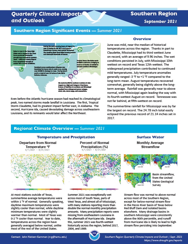
At most stations outside of Texas, summertime average temperatures were within 1 °F of normal. Most of Texas was 0-2 °F cooler than normal. Summer 2021 was exceptionally wet across most of South Texas, parts of West Texas, and almost all of Mississippi, with many stations reporting more than double the normal monthly precipitation amounts.
Quarterly Climate Impacts and Outlook for the Southern Region for March - May 2021. Dated June 2021.
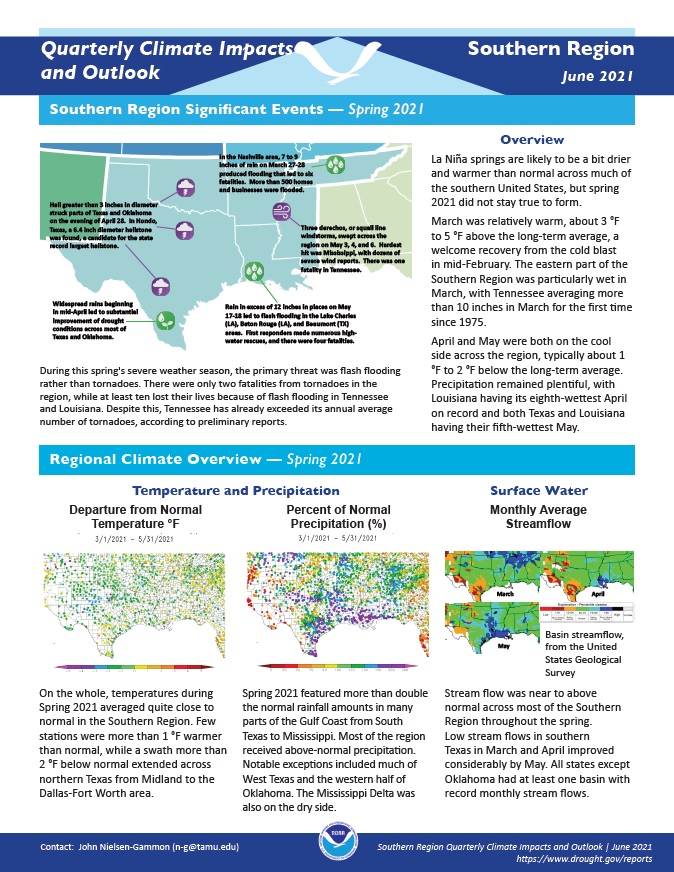
On the whole, temperatures during Spring 2021 averaged quite close to normal in the Southern Region. Spring 2021 featured more than double the normal rainfall amounts in many parts of the Gulf Coast from South Texas to Mississippi. Most of the region received above-normal precipitation.
Quarterly Climate Impacts and Outlook for the Southern Region for December 2020 – February 2021. Dated March 2021.
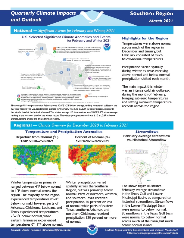
Winter temperatures primarily ranged between 4°F below normal to 1°F above normal across the region. Winter precipitation varied spatially across the Southern Region, but was primarily below normal.
Quarterly Climate Impacts and Outlook for the Southern Region for September – November 2020. Dated December 2020.
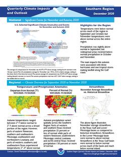
Temperatures were below normal across much of the region in September and October, but November temperatures were above normal across the entire region. Precipitation was slightly above normal in September, but widespread areas received below normal precipitation in October and November.
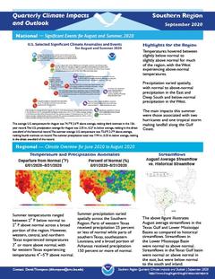
Quarterly Climate Impacts and Outlook for the Southern Region for June – August 2020. Dated September 2020.
Temperatures hovered between slightly below normal to slightly above normal for much of the region, with the West experiencing above-normal temperatures. Precipitation varied spatially, with normal to above-normal precipitation in the East and Deep South and below-normal precipitation in the West.
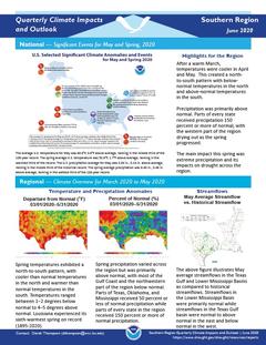
Quarterly Climate Impacts and Outlook for the Southern Region for March – May 2020. Dated June 2020.
After a warm March, temperatures were cooler in April and May. This created a north-to-south pattern with below-normal temperatures in the north and above-normal temperatures in the south. Precipitation was primarily above normal. Parts of every state received precipitation 150 percent or more of normal, with the western part of the region drying out as the spring progressed.
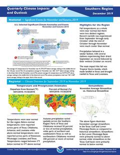
Quarterly Climate Impacts and Outlook for the Southern Region for September – November 2019. Dated December 2019.
Fall temperatures as a whole were near normal, but there were two distinct regimes. Record warmth was experienced from September through early October while the end of October through November were much cooler than normal. Precipitation behaved in a similar fashion, with several stations experiencing their driest September on record followed by their wettest October on record.
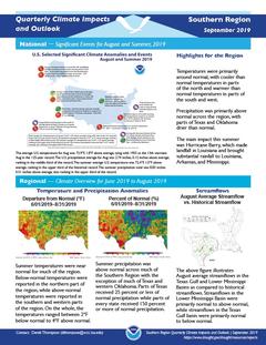
Quarterly Climate Impacts and Outlook for the Southern Region for June – August 2019. Dated September 2019.
Summer temperatures were near normal for much of the region. Below-normal temperatures were reported in the northern part of the region, while above-normal temperatures were reported in the southern and western parts of the region. Summer precipitation was above normal across much of the Southern Region with the exception of much of Texas and western Oklahoma.
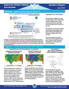
Quarterly Climate Impacts and Outlook for the Southern Region for March – May 2019. Dated June 2019.
Spring temperatures exhibited a west-to-east pattern across the region in general, with above normal temperatures in the east and normal to slightly below normal temperatures in the western states. Spring precipitation was primarily above normal across the Southern Region.
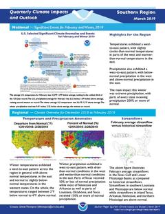
Quarterly Climate Impacts and Outlook for the Southern Region for December 2018 – February 2019. Dated March 2019.
Winter temperatures exhibited a west-to-east pattern across the region in general, with above normal temperatures in the east and normal to slightly below normal temperatures in the western states. Winter precipitation also exhibited a west-to-east pattern, with drier than normal conditions in the west and wetter than normal conditions in the east.