Native Drought Resilience: Confederated Salish & Kootenai Tribes (CSKT) Actions for Climate-Drought Adaptation
The Native Drought Resilience project builds Tribal capacity to monitor, understand, and respond to climate and drought impacts on the Flathead Reservation. Guided by the Confederated Salish and Kootenai Tribes (CSKT) Climate Change Strategic Plan and rooted in Indigenous values and knowledge, the Native Drought Resilience project fosters local leadership, supports informed decision-making, and advances community-based adaptation actions.
Key Accomplishments
- Enhanced the Upper Missouri River Basin Drought Monitoring & Indicators Dashboard to facilitate use for CSKT drought monitoring and response. The dashboard now features local-scale zoom and new Forest Drought Severity Index data.
- Provided internships that placed CSKT and Salish Kootenai College students in leadership roles.
- Created training tools and conducted public outreach and communications:
- Developed online modular training tools using CSKT Bison Range Mesonet station data, public tutorials for the Montana Mesonet and Drought Indicators Dashboard, and a dashboard training webinar.
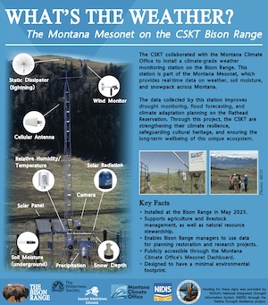
- Provided interpretive signs in a highly-visited area for the new Bison Range Mesonet station, which include information on the Mesonet station and climate and drought impacts on Bison Range ecosystems:
- Conducted outreach and engagement activities around new PurpleAir air quality sensors, including integration into elementary, middle, and high school curricula, creation of an air quality flag warning system, and development of a response toolkit for building managers in partnership with Montana Department of Public Health and Human Services.
- Deployed Mesonet weather & PurpleAir air quality monitoring networks:
- Bison Range Mesonet station installed in May 2023, providing real-time data every 5 minutes.
- 44 PurpleAir Network sensors installed at schools, clinics, and government offices.
- Data from these sensors are available on a public CSKT Air Quality Dashboard, PurpleAir Map, and U.S. EPA AirNow Fire and Smoke Map.
- Open-source code and other cyber-infrastructure are publicly available via GitHub.
- Designed eight Story Maps to communicate native resilience, empowering residents of the Flathead Reservation to learn more about the environmental challenges in this region and the interconnected efforts of each sector to ensure a robust and healthy environment for generations to come. The first four sector Story Maps were recognized with the 2023 Esri Native Nations TEK Award.
For more information, please contact Crystal Stiles (crystal.stiles@noaa.gov) or Britt Parker (britt.parker@noaa.gov).
Research Snapshot
Kyle Bocinsky, Montana Climate Office, University of Montana
Michael Durglo, Confederated Salish and Kootenai Tribes Climate Resiliency Office; Virgil Dupuis, Salish Kootenai College Extension; Zach Hoylman and Maureen McCarthy, Montana Climate Office, University of Montana; and Anne Carlson, The Wilderness Society
Impacts and Outcomes of This Research
 Expanded monitoring capacity: The CSKT Bison Range Mesonet station and distributed PurpleAir network now provide continuous, real-time environmental data, which inform both health alerts and long-term planning. Tribal departments are being trained to interpret and act on these data, and the tools are used in both emergency management and public health education.
Integrated decision support: The Drought Indicators Dashboard now includes localized indicators such as the Forest Drought Response Index (ForDRI), enabling operational planning for drought and wildfire risks. This integration supports both short-term response and long-term adaptation planning at Tribal and regional scales through support from our partnership with the Native Resilience program.
Local empowerment: Tools and trainings developed through the Native Drought Resilience project directly support CSKT capacity to understand and respond to drought and climate risks. By integrating real-time data, local monitoring networks, and culturally relevant decision tools, CSKT departments are now better equipped to make risk-informed management decisions.
Replicable model: The frameworks and tools developed—including local enhancements to the Drought Indicators Dashboard, the PurpleAir and Mesonet networks, and the internship program—have been adopted as a model for Tribal resilience planning. Other Native Nations have expressed interest in adapting these systems for their own use, supported by the open-source infrastructure and templates made available through the project. Code and resources developed through the Native Drought Resilience project are currently being leveraged in collaboration with the Montana Department of Environmental Quality, Montana Department of Public Health and Human Services, University of Montana School of Public and Community Health Sciences, and NOAA’s National Integrated Drought Information System.
Community engagement: Interactive, place-based tools such as Story Maps and training modules have helped bridge Western science and Indigenous knowledge, making drought and climate adaptation more accessible to the community. As of 2025, a full suite of sector-based ArcGIS StoryMaps is complete and actively used in community outreach, school programs, and the ongoing communication around the strategic plan.
Workforce development: Interns from Salish Kootenai College and CSKT have gained meaningful experience in environmental monitoring, data analysis, and communication. The final cohort completed their work in summer 2025, contributing to long-term workforce capacity.
View news coverage of the Bison Range mesonet station installation (Drought.gov, Char-Koosta News), CSKT Story Maps winning the 2023 Esri Native Nations TEK Award (Esri, Drought.gov), and the PurpleAir network installation (University of Montana).
Related Data & Maps
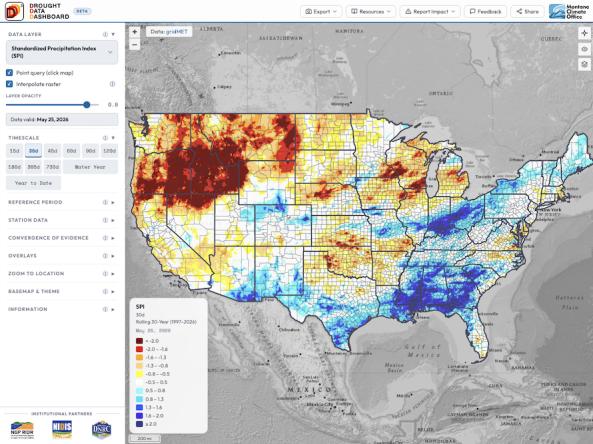
The Drought Data Dashboard, or D³, is an interactive mapping tool that allows users to view, analyze, and customize the display of key drought indices and climate variables across the co