Southeast Drought Status Update - October 2019
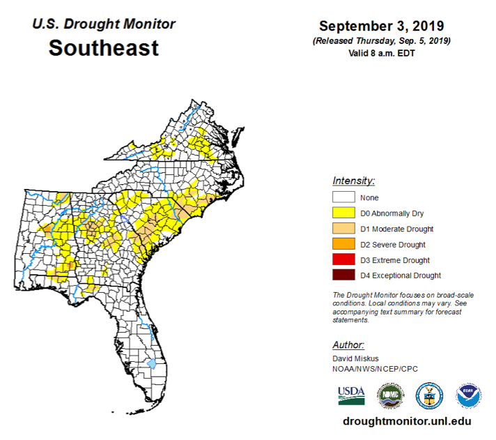
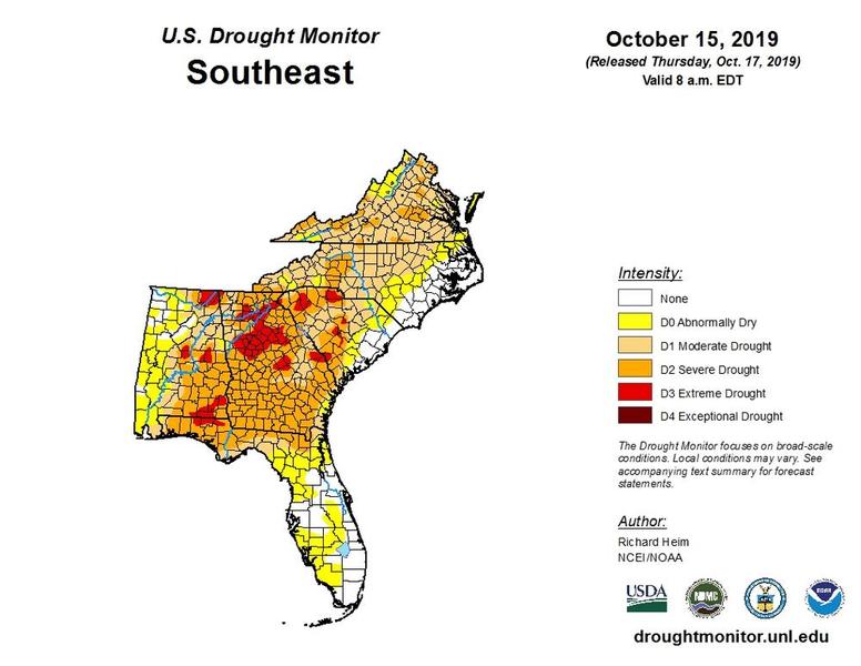
The Southeast is currently experiencing a "Flash Drought." Drought conditions increased throughout the month of September due to extreme dryness and warmer than average temperatures for most of the region. The exceptions include the eastern Carolinas and southern Florida, which were impacted by Hurricane Dorian.
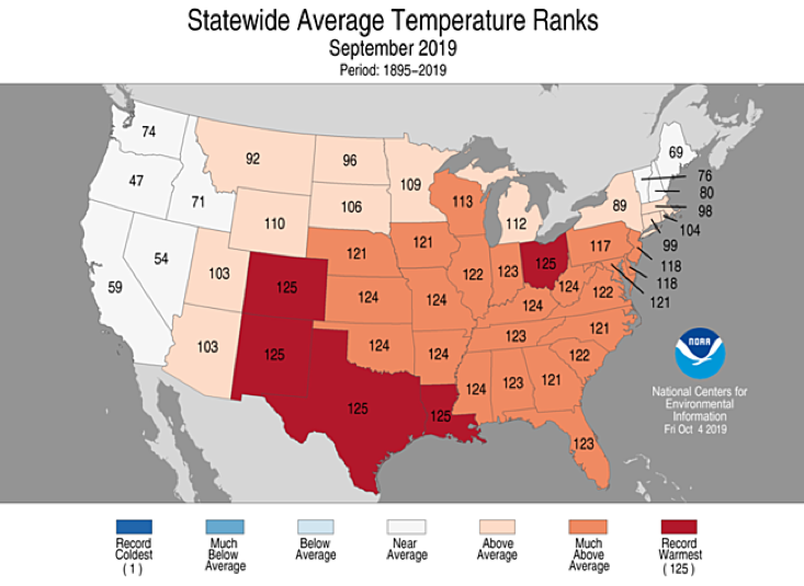
- It has been HOT. Temperatures were much above average across the Southeast for the month of September. Record warm temperatures of 8 F to 12 F above normal have occured in early October across the entire Southeast.
- It has been DRY. Precipitation was well below normal across much of the Southeast region during September, with monthly totals ranging from 50 to less than 5 percent of normal. Numerous parts of the Southeast saw their driest September on record.
Impacts are being felt across the Southeast region.
- The agriculture sector is currently the hardest hit by drought.
- Streamflows are declining and are a growing concern in some parts of the region.
- States are starting to issue drought advisories and declarations.
Examples of Current Impacts on Agriculture
- The dry weather has provided limited benefits for a few crops, such as irrigated wine grape production.
- Drought conditions have led resulted in negative impacts on forage and livestock
- Pastures and hay fields have stopped growing, leading to need to feed hay as early as June.
- Feeding hay to livestock is more expensive and makes it more difficult to manage cattle nutrition.
- Water supplies are drying up in small streams and ponds.
- Dry soils are preventing fall planting of winter pastures and small grains.
- Additional negative impacts include peanuts and other crops Dryland peanut producers are holding back on harvesting, hoping for rain to soften the soils
- Early nut drop is being reported for pecans in some locations.
- Heat is detrimental for pollination and fruit production. Difficulty with pollinating dryland corn resulted in reduced corn yields.
- Blueberries and peaches are struggling due to stress from high temperatures.
- Forest leaves are browning and dropping prematurely.
- Additional problems may develop in other crops next year due to water and heat stress, but it is too early to tell.
- The dry conditions may lead to an increase in the number of wildfires.
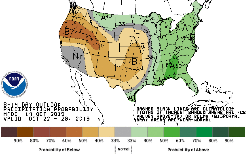
Drought Outlook
There is a high probability of short term improvement through the end of October, due to cooling temperatures and increased chances for above normal rainfall. Parts of southern Alabama and south Georgia have seen 2"-4" of rain in the past week. However, no strong signal appears on the horizon for November.
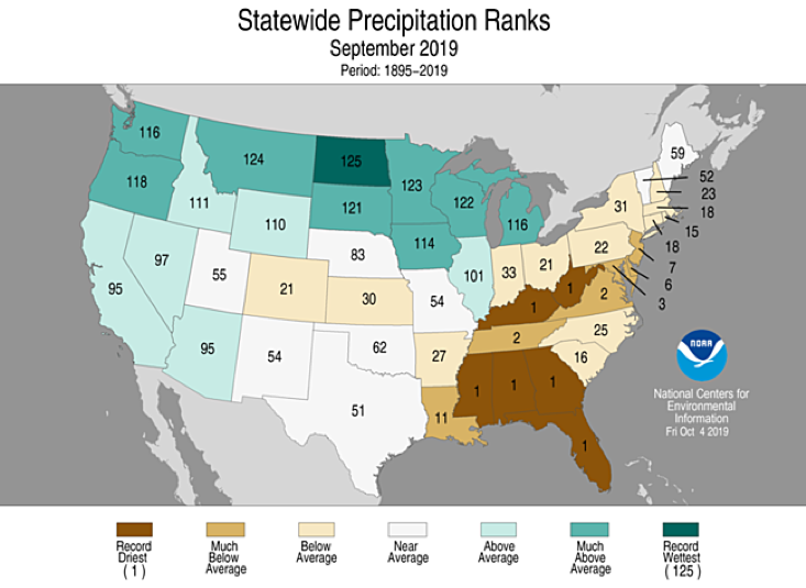
Source: NOAA NCEI, National Climate Report, September 2019
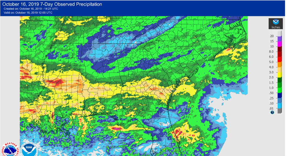
Source: NOAA National Weather Service (https://water.weather.gov/precip)
This Drought Update is part of drought-related webinars offered across the U.S. by the National Integrated Drought Information System (NIDIS).
NIDIS and partners held a Southeast Drought Update Webinar on October 10. The recorded version can be found here.
This drought status report was developed from a webinar presented on 10 October 2019 by Victor Murphy, NOAA National Weather Service Southern Region, and Pam Knox, University of Georgia.