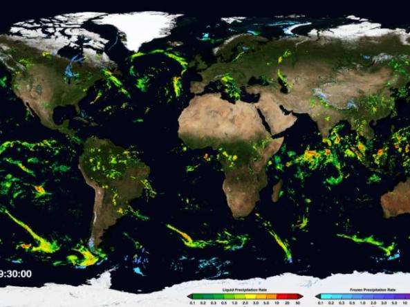
NASA Global Precipitation Measurement (GPM) - IMERG
NASA
The Integrated Multi-satellitE Retrievals for GPM (IMERG) algorithm combines information from the GPM satellite constellation to estimate precipitation over the majority of the Earth's surface. This algorithm is particularly valuable over the majority of the Earth's surface that lacks precipitation-measuring instruments on the ground. Now in the latest Version 06 release of IMERG the algorithm fuses the early precipitation estimates collected during the operation of the TRMM satellite (2000 - 2015) with more recent precipitation estimates collected during operation of the GPM satellite (2014 - present). The longer the record, the more valuable it is, as researchers and application developers will attest. By being able to compare and contrast past and present data, researchers are better informed to make climate and weather models more accurate, better understand normal and extreme rain and snowfall around the world, and strengthen applications for current and future disasters, disease, resource management, energy production and food security.
Precipitation Accumulation
Inches of Precipitation
This location received less than 0.01 inch of precipitation during this 7-day period.
This location received 0.01–0.5 inch of precipitation during this 7-day period.
This location received 0.5–1 inch of precipitation during this 7-day period.
This location received 1–2 inches of precipitation during this 7-day period.
This location received 2–4 inches of precipitation during this 7-day period.
This location received 4–6 inches of precipitation during this 7-day period.
This location received 6–8 inches of precipitation during this 7-day period.
This location received more than 8 inches of precipitation during this 7-day period.
Percent of Normal Precipitation
Precipitation Shown as a Percentage of Normal Conditions
<25% of Normal
Precipitation was only 0% to 25% of the historical average for this location, compared to the same date range from 1991–2020.
25%–50% of Normal
Precipitation was 25% to 50% of the historical average for this location, compared to the same date range from 1991–2020.
50%–75% of Normal
Precipitation was 50% to 75% of the historical average for this location, compared to the same date range from 1991–2020.
75%–100% of Normal
Precipitation was 75% to 100% of the historical average for this location, compared to the same date range from 1991–2020.
100%–150% of Normal
Precipitation was 100% to 150% of the historical average for this location, compared to the same date range from 1991–2020.
150%–200% of Normal
Precipitation was 150% to 200% of the historical average for this location, compared to the same date range from 1991–2020.
200%–300% of Normal
Precipitation was 200% to 300% of the historical average for this location, compared to the same date range from 1991–2020.
>300% of Normal
Precipitation was greater than 300% of the historical average for this location, compared to the same date range from 1991–2020.
This map shows the percent of normal precipitation, when comparing the precipitation accumulation for the 30 days prior to the valid date with the average of the accumulation totals for the same 30 day period between 1991 and 2020.
The Drought.gov team produces this product with the Climate Engine tool and the ECMWF ERA5 dataset. ERA5 is the fifth generation ECMWF atmospheric reanalysis of the global climate covering the period from January 1940 to present. ERA5 is produced by the Copernicus Climate Change Service (C3S) at ECMWF.
This map shows the percent of normal precipitation, when comparing the precipitation accumulation for the 60 days prior to the valid date with the average of the accumulation totals for the same 60 day period between 1991 and 2020.
The Drought.gov team produces this product with the Climate Engine tool and the ECMWF ERA5 dataset. ERA5 is the fifth generation ECMWF atmospheric reanalysis of the global climate covering the period from January 1940 to present. ERA5 is produced by the Copernicus Climate Change Service (C3S) at ECMWF.
This map shows the percent of normal precipitation, when comparing the precipitation accumulation for the 90 days prior to the valid date with the average of the accumulation totals for the same 90 day period between 1991 and 2020.
The Drought.gov team produces this product with the Climate Engine tool and the ECMWF ERA5 dataset. ERA5 is the fifth generation ECMWF atmospheric reanalysis of the global climate covering the period from January 1940 to present. ERA5 is produced by the Copernicus Climate Change Service (C3S) at ECMWF.
This map shows the percent of normal precipitation, when comparing the precipitation accumulation for the 180 days prior to the valid date with the average of the accumulation totals for the same 180 day period between 1991 and 2020.
The Drought.gov team produces this product with the Climate Engine tool and the ECMWF ERA5 dataset. ERA5 is the fifth generation ECMWF atmospheric reanalysis of the global climate covering the period from January 1940 to present. ERA5 is produced by the Copernicus Climate Change Service (C3S) at ECMWF.
This map shows the percent of normal precipitation, when comparing the precipitation accumulation for the 270 days prior to the valid date with the average of the accumulation totals for the same 270 day period between 1991 and 2020.
The Drought.gov team produces this product with the Climate Engine tool and the ECMWF ERA5 dataset. ERA5 is the fifth generation ECMWF atmospheric reanalysis of the global climate covering the period from January 1940 to present. ERA5 is produced by the Copernicus Climate Change Service (C3S) at ECMWF.
This map shows the percent of normal precipitation, when comparing the precipitation accumulation for the 365 days prior to the valid date with the average of the accumulation totals for the same 365 day period between 1991 and 2020.
The Drought.gov team produces this product with the Climate Engine tool and the ECMWF ERA5 dataset. ERA5 is the fifth generation ECMWF atmospheric reanalysis of the global climate covering the period from January 1940 to present. ERA5 is produced by the Copernicus Climate Change Service (C3S) at ECMWF.
Updates daily with a delay of 6-8 days