U.S. Gridded Standardized Precipitation Index (SPI) from nClimGrid-Monthly
National Oceanic and Atmospheric Administration's (NOAA) National Centers for Environmental Information (NCEI)
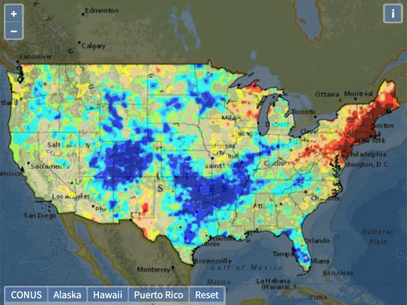
The U.S. Gridded Standardized Precipitation Index (SPI) captures how observed precipitation deviates from the climatological average (using the base period 1895–2014) over a given time period. It is derived from the nClimGrid-Monthly dataset and includes timescales of 1, 2, 3, 6, 9, 12, 24, 36, 48, 60 and 72 months. The nClimGrid-monthly dataset is a gridded dataset derived from spatially interpolating data from the Global Historical Climatology Network (GHCN), starting in 1895.
The SPI is available with both the gamma and Pearson Type III types of distribution fittings, using the Python Drought Indices open-source package.
HOW TO
How to use this site:
- Datasets are in netCDF format
- The netCDF files are readable by many software packages
ACCESS
SPI from nClimGrid-Monthly in NetCDF: Available for download from NOAA/NIDIS/NCEI
Drought.gov Historical Time Series Tool: View the 9-month SPI as an interactive time series and map and compare to other historical drought datasets
Related Publications
Guttman, N. B., 1999: Accepting the standardized precipitation index: A calculation algorithm. J. Amer. Water Resour. Assoc., 35, 311–322, https://doi.org/10.1111/j.1752-1688.1999.tb03592.x.
Wu, H., M. J. Hayes, D. A. Wilhite, and M. D. Svoboda, 2005: The effect of length of record on the standardized precipitation index. Int. J. Climatol., 25, 505–520, https://doi.org/10.1002/joc.1142.
Wu, H., M. D. Svoboda, M. J. Hayes, D. A. Wilhite, and F. Wen, 2007: Appropriate application of the standardized precipitation index in arid locations and dry seasons. Int. J. Climatol., 27, 65–79, https://doi.org/10.1002/joc.1371.
Cumbie-Ward, R. V., and R. P. Boyles, 2016: Evaluation of a high-resolution SPI for monitoring local drought severity. J. Appl. Meteor. Climatol., 55, 2247–2262, https://doi.org/10.1175/JAMC-D-16-0106.1.
Vose, R. S., and et al, 2014a: NOAA’s Gridded Climate Divisional Dataset (CLIMDIV). NOAA National Climatic Data Center, accessed 4 June 2018, https://doi.org/10.7289/V5M32STR.