Quarterly Climate Impacts and Outlook for the Great Lakes Region for September–November 2025. Dated December 2025.
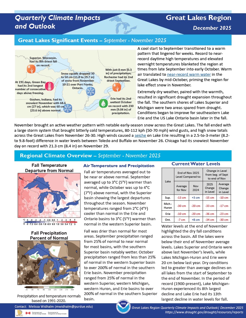
Fall air temperatures averaged out to be near or above normal. Fall was drier than normal for most areas. Dry conditions led to greater than average declines on all lakes from the start of September to the end of November. In the period of record (1900-present), Lake Michigan-Huron experienced its 8th largest decline and Lake Erie had its 13th largest decline in water levels for fall.

Quarterly Climate Impacts and Outlook for the Gulf of Maine Region for September–November 2025. Dated December 2025.
Autumn featured near- to above-normal temperatures, ranking among the 10 warmest autumns for several Maritimes sites including Moncton, N.B.; Halifax, N.S.; and Summerside, P.E.I. Below- to near-normal precipitation fueled intense drought conditions that resulted in many impacts, particularly on water resources and agriculture.
Quarterly Climate Impacts and Outlook for the Southeast and Caribbean Region for September–November 2025. Dated December 2025. (Updated to add Spanish translation of Caribbean information.)
Quarterly Climate Impacts and Outlook for the Mid-Atlantic Region for September–November 2025. Dated December 2025.
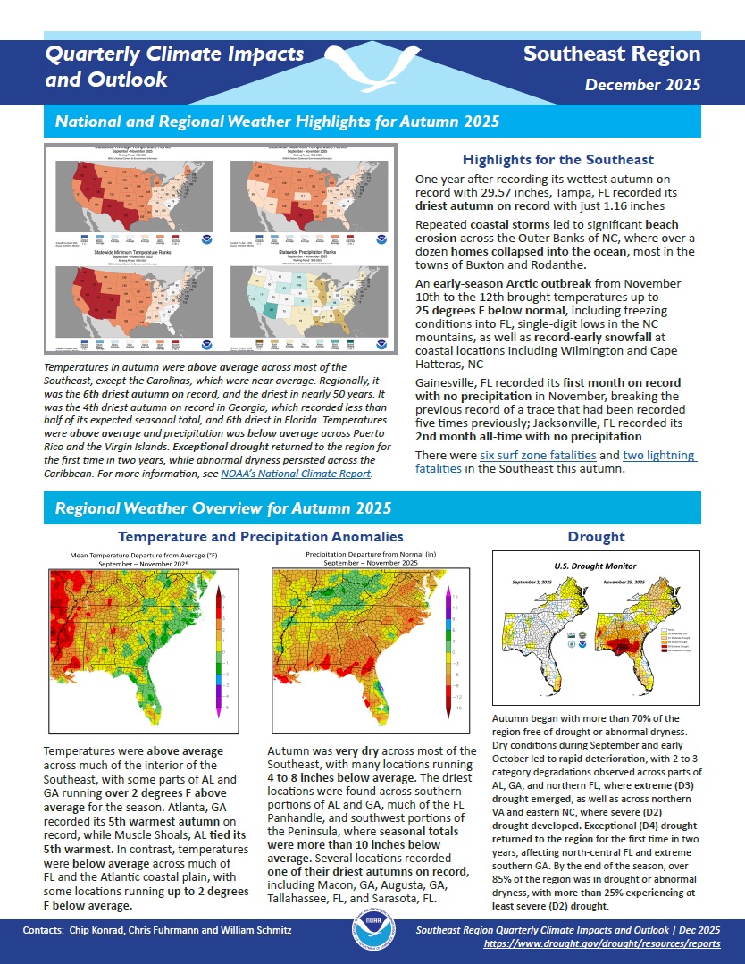
Fall temperatures were within about 2°F of normal across almost the entire region. Most areas were drier than normal, with drought or abnormal dryness present throughout the fall. Low water levels led to water restrictions and poor pasture conditions resulted in early livestock sales.
Quarterly Climate Impacts and Outlook for the Western Region for September–November 2025. Dated December 2025.
Quarterly Climate Impacts and Outlook for the Pacific Region for September–November 2025. Dated December 2025.
In March 2020, Moderate to Severe Drought (D1-D2) intensified rapidly to Exceptional Drought (D4) along the lower Rio Grande in Texas, according to the U.S. Drought Monitor. Over the next five years, drought severity waxed and waned across the Southern Plains, shifting location and extent but never leaving the region. Drought touched the lives of nearly every resident of the Southern Plains states (Texas, Oklahoma, and Kansas).
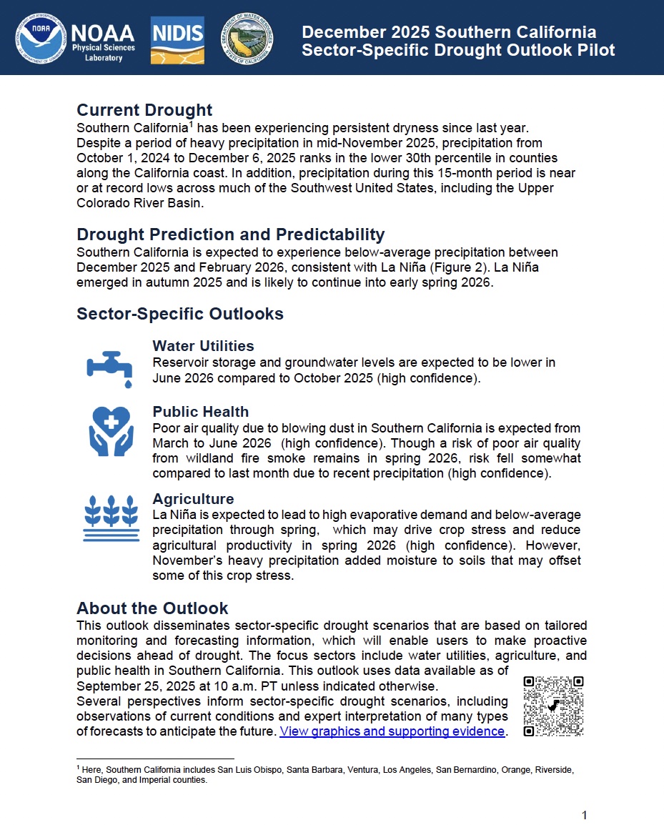
NOAA’s National Integrated Drought Information System (NIDIS) and Physical Sciences Laboratory are partnering with the California State Climatologist/California Department of Water Resources, NOAA’s National Weather Service and National Centers for Environmental Information, and the California-Nevada Adaptation Program (a NOAA CAP team) on the Sector-Specific Drought Early Warning Outlook – Southern California Pilot.
This report, Facing Future Droughts: Lessons from the Southeast’s 2023 Fall Flash Drought, was developed to improve the monitoring, communication, and response to drought in the Southeastern United States, with a specific focus on flash drought. The 2019 flash drought exposed critical gaps in early warning and monitoring systems, sparking conversations that continued during the 2022 Southeast Drought Early Warning System (DEWS) Regional Meeting.
Quarterly Climate Impacts and Outlook for the Mid-Atlantic Region for June–August 2025. Dated September 2025.
Average temperatures for the 2025 summer season were a bit above normal (0-4 degrees) across the region. This was due to warmer than normal temperatures in late June and July followed by a cooler than normal August. Precipitation varied across the watershed,some locations saw precipitation significantly above normal in June and July then dropping to drier, below normal conditions in August.