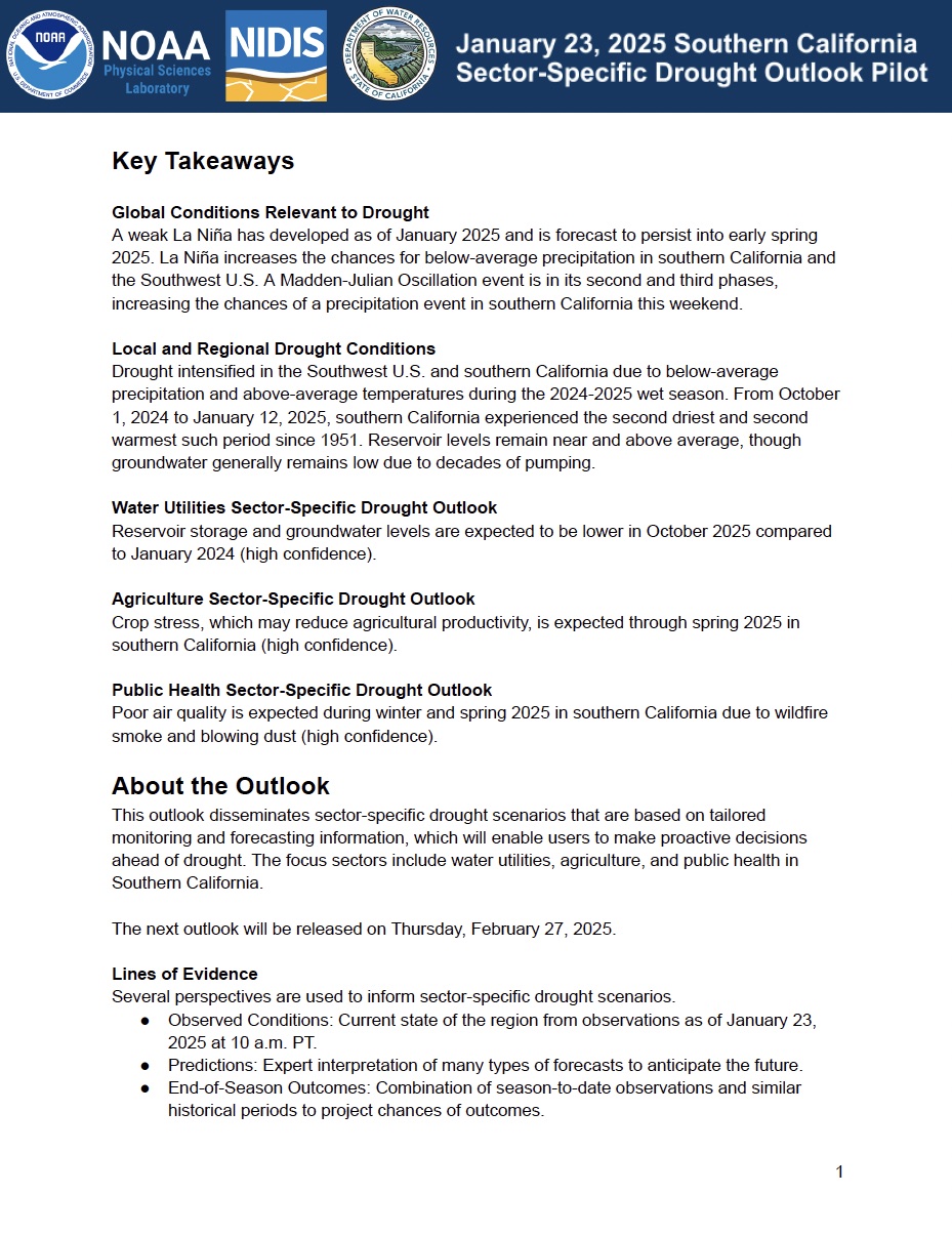
NOAA’s National Integrated Drought Information System (NIDIS) and Physical Sciences Laboratory are partnering with the California State Climatologist/California Department of Water Resources, NOAA’s National Weather Service and National Centers for Environmental Information, and the California-Nevada Adaptation Program (a NOAA CAP team) on the Sector-Specific Drought Early Warning Outlook – Southern California Pilot.
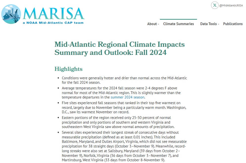
Quarterly Climate Impacts and Outlook for the Mid-Atlantic Region for September–November 2024. Dated December 2024.
Average temperatures for the 2024 fall season were 2-4 °F above normal for most of the Mid-Atlantic region. Eastern portions of the region received only 25%–50% of normal precipitation. Only portions of southern and western Virginia and southeastern West Virginia saw above-normal precipitation.
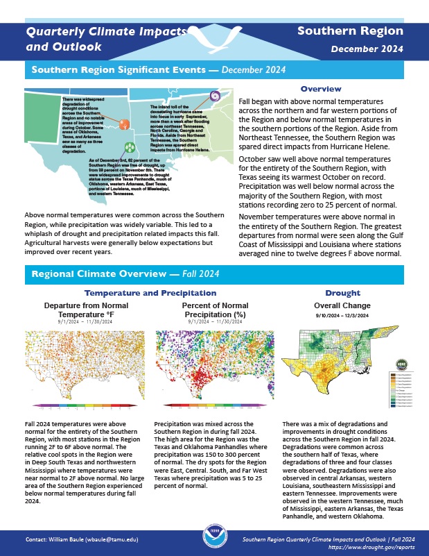
Quarterly Climate Impacts and Outlook for the Southern Region for September–November 2024. Dated December 2024.
Fall temperatures were above normal for the entirety of the Southern Region, with most stations in the Region running 2 °F to 6 °F above normal. Precipitation was mixed across the region during the fall.
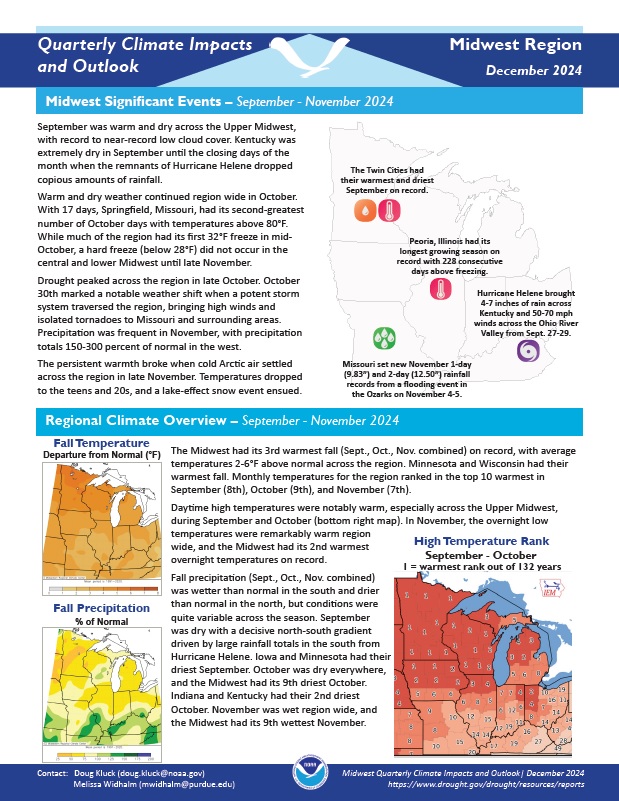
Quarterly Climate Impacts and Outlook for the Midwest Region for September–November 2024. Dated December 2024.
The Midwest had its 3rd warmest fall on record, with average temperatures 2-6 °F above normal across the region. Minnesota and Wisconsin had their warmest fall. Monthly temperatures for the region ranked in the top 10 warmest in September (8th), October (9th), and November (7th). Fall precipitation was wetter than normal in the south and drier than normal in the north, but conditions were quite variable across the season.
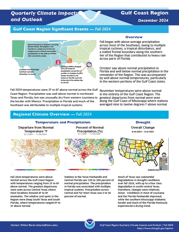
Quarterly Climate Impacts and Outlook for the Gulf Coast Region for September–November 2024. Dated December 2024.
Fall temperatures were above normal across the Gulf Coast Region with temperatures ranging from 2 °F to 6 °F above normal. Stations in the Texas Panhandle and Central Florida saw 150%–300% of normal precipitation. The precipitation in Florida was associated with multiple tropical systems. Precipitation across Central and Far West Texas was 5%–50% of normal.
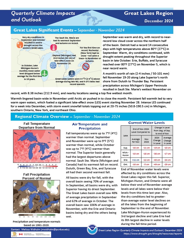
Quarterly Climate Impacts and Outlook for the Great Lakes Region for September–November 2024. Dated December 2024.
Fall temperatures were up to 7 °F (4 °C) warmer than normal. All basins were dry for fall, with the overall basin seeing 70% of average precipitation.
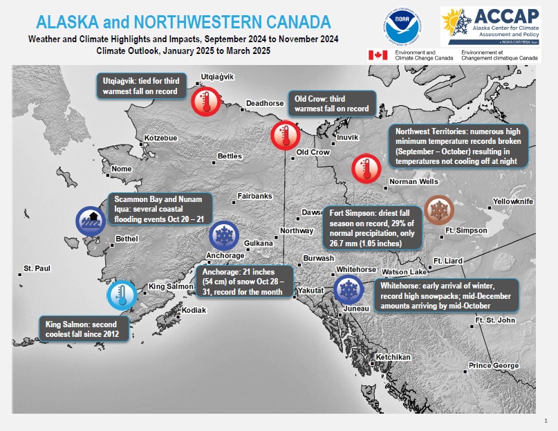
Quarterly Climate Impacts and Outlook for Alaska and Northwestern Canada for September–November 2024, with an outlook for January–March 2025. Dated December 2024.
Environment and Climate Change Canada, NOAA, and partners created these climate outlooks to inform the public about recent climate impacts within their respective regions. Each regional report contains easy-to-understand language, and anyone can access them through the U.S. Drought Portal.
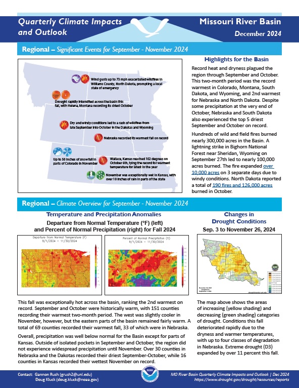
Quarterly Climate Impacts and Outlook for the Missouri River Basin for September–November 2024. Dated December 2024.
This fall was exceptionally hot across the basin, ranking the second warmest on record. Precipitation was well below normal for the Basin except for parts of Kansas.
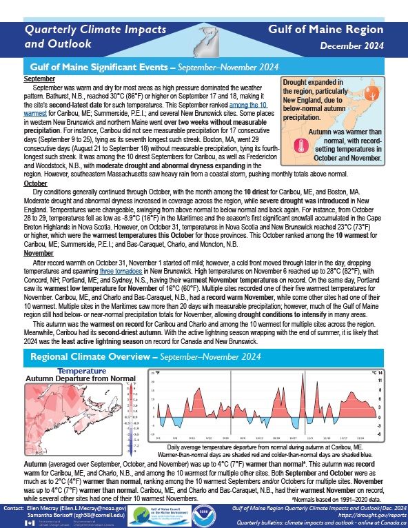
Quarterly Climate Impacts and Outlook for the Gulf of Maine Region for September–November 2024. Dated December 2024.
Autumn was up to 4°C (7°F) warmer than normal. This autumn was record warm for Caribou, ME, and Charlo, N.B., and among the 10 warmest for multiple other sites. Precipitation for autumn ranged from 25% of normal to near normal for most areas.
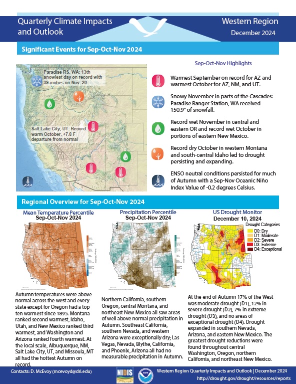
Quarterly Climate Impacts and Outlook for the Western Region for September–November 2024. Dated December 2024.
Autumn temperatures were above normal across the West, and every state except for Oregon had a top ten warmest autumn since 1895. Northern California, southern Oregon, central Montana, and northeast New Mexico all saw areas of well-above-normal precipitation in autumn. Southeast California, southern Nevada, and western Arizona were exceptionally dry.