Some rain and snow last week and some ahead though drought conditions remain.
Key Points
- Building on dry conditions in the last year, drought has expanded and worsened in California and Nevada since the start of the water year due to below average precipitation and above normal temperatures and evaporative demand.
- D4 (Exceptional Drought according to the U.S. Drought Monitor) is now present in California as well as Nevada.
- Last week the northern parts of California and Nevada received between 0.5 to 2 inches of rain throughout much of the region.
- 7-day precipitation forecasts indicate between a trace and 3 inches of precipitation for Central and Northern California and far Northwest Nevada.
- Even with the recent and forecast precipitation, drought impacts remain and preparation for a potential dry year (and second dry year for some areas) is needed.
U.S. Drought Monitor Conditions: California-Nevada |

U.S. Drought Monitor for CA/NV for December 15, 2020. Source: https://droughtmonitor.unl.edu/.
Current Conditions
- The dry start to the 2021 water year (Oct. 1, 2020 - Sept. 30, 2021) continues to build California and Nevada precipitation deficits from last year with new development in Southern California.
- According to the U.S. Drought Monitor, areas of Severe Drought (D2) to Exceptional Drought (D4) expanded in S. California where precipitation during the past 90-day period has generally been less than 25% of normal. These areas largely have missed recent storm events that have impacted central and northern portions of the state.
- In S. Nevada, areas of Exceptional Drought (D4) expanded in Clark County. McCarran International Airport (through Dec. 1) has had 240 days without measurable precipitation ending on 16th Dec, a station record observed for the period.
- Evaporative demand over the last month has been high and soil moisture and shallow groundwater is low throughout the region.
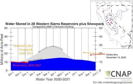
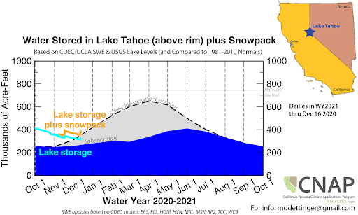
- Water Storage (reservoir+snow) in Lake Tahoe region is above normal because of high lake levels after recent wet years and below normal in the Sierras due to low snowpack. Dry snow drought conditions due to low precipitation are present across the Sierras and the Southwestern U.S.
- The odds of reaching normal precipitation for the water year is between 20% to 30% throughout much of California and Nevada.
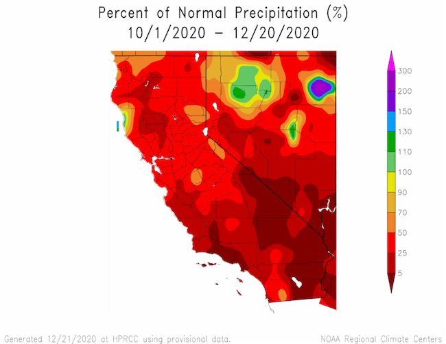
Percent of Normal Precipitation for the Last Year. Source: HPRCC
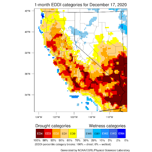
1-Month Evaporative Demand Drought Index (EDDI) from NOAA/ESRL and the Great Basin Dashboard. Valid December 17, 2020.
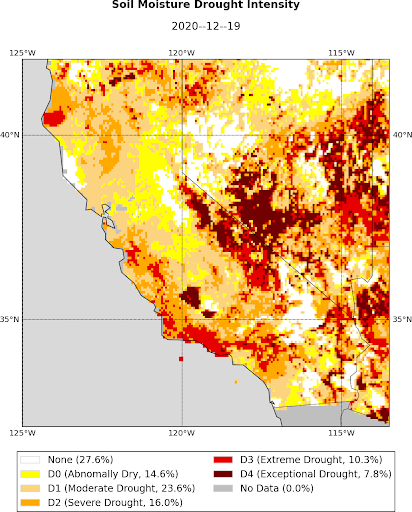
Soil Moisture Percentiles from the UCLA Drought Monitor. Valid December 19, 2020.
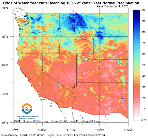
The odds of reaching normal precipitation based on historical water year totals. The dry start to the water year means the odds of reaching normal precipitation is between 20-30% throughout the region. Learn more about the product at CW3E website.
Drought Impacts
- The impact of both short- and long-term dryness in parts of California has been affecting the cattle ranching industry with numerous drought impact reports describing severe impacts to pasture and rangeland conditions as well as reports of ranchers having to sell livestock.
- The California Department of Water Resources announced the initial water allocation of 10% for the State Water Project (December 1st).
Drought & Climate Outlook
ENSO
NOAA’s ENSO alert system status is currently a La Niña advisory and is likely to continue through the Northern Hemisphere winter 2020-21 (~95% chance during January-March). For more information please check out the NOAA ENSO blog.
Western Regional Climate Center recently developed a handout about the La Niña impacts for the West. Check it out to see how La Niña historically has affected your region.
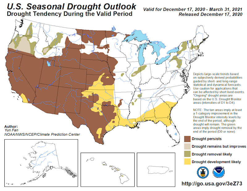
Seasonal Drought Outlook
As of the mid-December seasonal (3-month) drought outlook, drought is expected to persist for most of the region and develop in the far southern coast of California.
Temperature & Precipitation
Current forecasts show potential moisture in N. and central California later this week, with a possibility of precipitation in S. California early next week. The 8-14 forecast (below) shows drier than normal conditions for most of the region. Newly released NOAA NWS Climate Prediction Center seasonal forecasts continue to show the dipole of wet/cool and dry/warm conditions along the west coast as common with La Niña conditions.
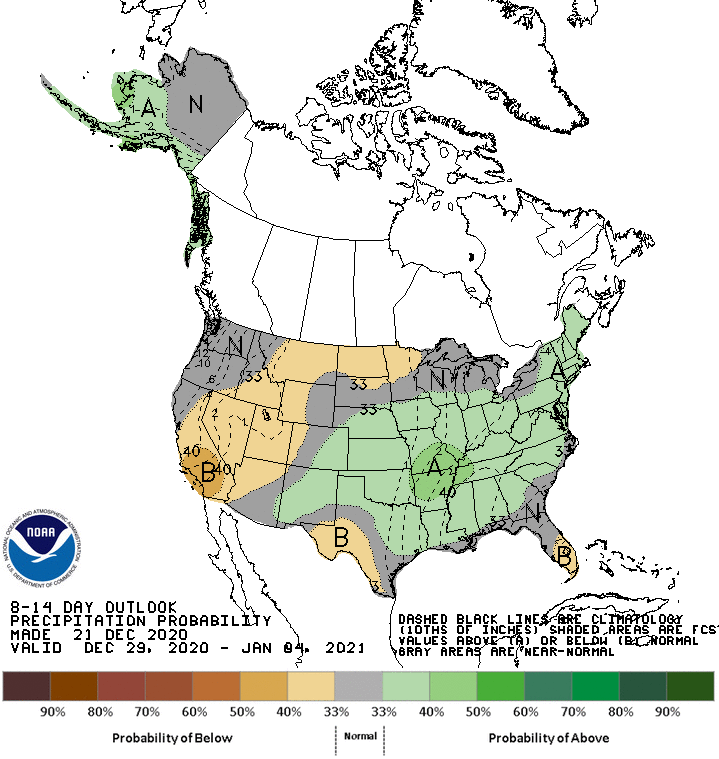
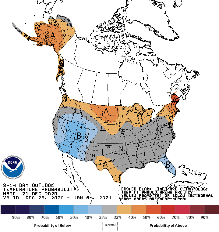
December 29-January 4 Precipitation Outlook (top) and Temperature Outlook (bottom). A = chances of above-normal; EC = equal chances of above, below, normal; B = chances of below-normal. Source: NOAA NWS Climate Prediction Center. How do I interpret these graphics?
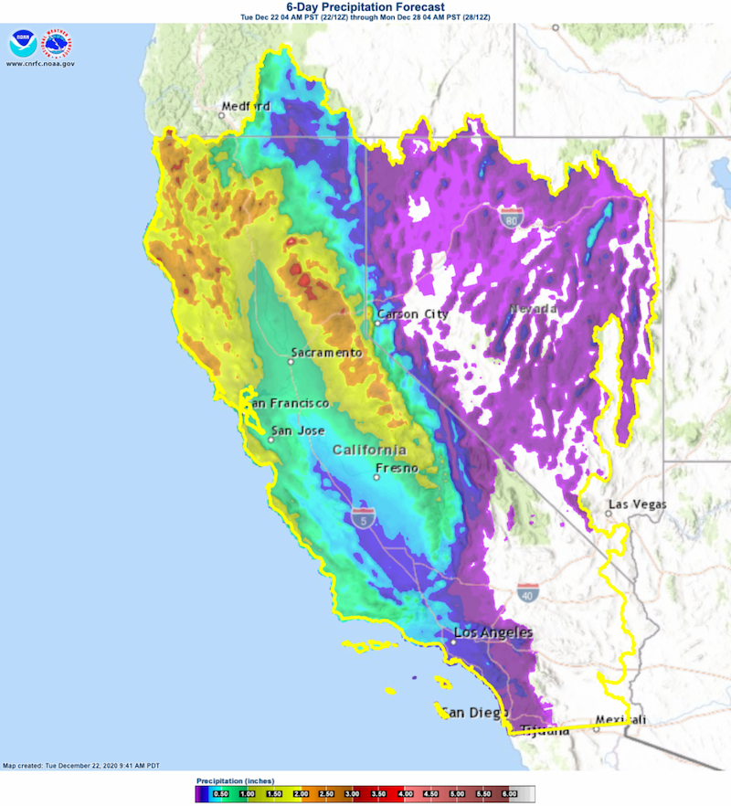
6-day forecast precipitation from from December 22-28 from NOAA NWS California-Nevada River Forecast Center.
Drought Early Warning Resources
Observations & Monitoring
- U.S. Drought Portal: Snow Drought Current Conditions Update (launched December 17)
- U.S. Drought Monitor
- California State Climatologist, California Data Exchange Center,
- Nevada State Climatologist
- National Drought Mitigation Center: Condition Monitoring Observer Reports (CMOR) and Drought Impacts Reporter
- Western Regional Climate Center (Past ENSO strength/precipitation figures)
- WestWide Drought Tracker
- Community Collaborative Rain, Hail, and Snow Network (CoCoRaHS)
- California-Nevada Applications Program Resources: Water Storage Tracking, UCLA Drought Monitor, Precipitation Tracking
- Climate Engine
- Great Basin Dashboard
- U.S. Water Watcher
Predictions & Forecasting
- Weather Forecasts: Your Local National Weather Service office, NOAA NWS California-Nevada River Forecast Center (streamflows)
- Subseasonal-to-seasonal (two weeks to three months): NOAA NWS Climate Prediction Center, ENSO, ENSO Blog
- 1-month Evaporative Demand Drought Index (EDDI) Forecasts
- Experimental Forecasts from the Center for Western Weather and Water Extremes Precipitation Forecasts, including:
Planning & Preparedness
- National Drought Mitigation Center Drought Planning
- California Drought Planning Resources
- Nevada Drought Planning Resources
Prepared By
Amanda Sheffield
NOAA/NIDIS California-Nevada DEWS Regional Drought Information Coordinator
Email: amanda.sheffield@noaa.gov
Julie Kalansky
Program Manager, California-Nevada Applications Program (NOAA RISA team)
Email: jkalansky@ucsd.edu
This Drought Status Update is issued in partnership between the National Oceanic and Atmospheric Administration (NOAA) and the California-Nevada Applications Program, a NOAA RISA team, to communicate the current state of drought conditions in California-Nevada based on recent conditions and the upcoming forecast. NIDIS and its partners will issue future Drought Updates as conditions evolve.
The next California-Nevada Drought & Climate Outlook webinar will take place on Monday, January 25 at 11 am PT.
