New Soil Moisture Research Results
Soil moisture is a critical variable and influences the climate system through modification of energy and moisture fluxes of the boundary layer. This in turn affects temperature, humidity, and precipitation. In addition, soil moisture is used as an indicator for agricultural drought, and recent studies have determined soil moisture as a key indicator of, and possible early warning for, flash drought in the United States. Due to its significance, accurate soil moisture information is critical for subseasonal-to-seasonal climate prediction as well as forecasting extreme events at those timescales.
The National Coordinated Soil Moisture Monitoring Network (NCSMMN), a NIDIS-led initiative, is laying the foundation for a high-resolution, real-time gridded soil moisture product that leverages data from in situ networks, satellite platforms, and land surface models. As a precursor to this development, NIDIS funded a study through NOAA’s Climate Program Office Modeling, Analysis, Predictions, and Projections (MAPP) Program to evaluate in situ soil moisture observations from 1,200+ stations. This was the first study to complete an in situ data validation effort at this scale in the United States. Since in situ soil moisture observations are vital for a comprehensive soil moisture monitoring infrastructure, evaluation of the United States’ current in situ soil moisture monitoring infrastructure can provide a means toward more informed satellite and model calibration and validation.
The study, published in the Journal of Hydrometeorology, employed a triple collocation approach to evaluate the fidelity of in situ soil moisture observations across the contiguous United States. The goal of the research was to determine the monitoring stations that are best suited for: (1) inclusion in national-scale soil moisture datasets, (2) deriving in-situ-informed gridded soil moisture products, and (3) validating and benchmarking satellite and model soil moisture data.
It was found that 90% of the 1,233 stations evaluated exhibited high spatial consistency with satellite remote sensing and land surface model soil moisture datasets. In addition, in situ error did not significantly vary by climate, soil type, or sensor technology, but instead, the stations with high error were affected by land cover and station factors that are more difficult to identify. The study authors included Trent Ford, Illinois State Climatologist; Steven Quiring, Chen Zhao, and Zachary T. Leasor, The Ohio State University; and Christian Landry, Southern Illinois University-Carbondale.
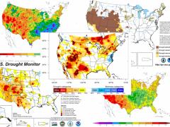
Another study, funded in part by NOAA’s Climate Program Office through the MAPP Program and also published in the Journal of Hydrometeorology, uses a new methodology that helps improve soil moisture predictions. The study combined remotely sensed soil moisture and evapotranspiration data with a land surface model to better characterize hydrologic fluxes in the Apalachicola–Chattahoochee–Flint (ACF) Basin in the Southeast United States. The model showed improvement in soil moisture predictions through the use of both evapotranspiration and soil moisture data. The authors also produced monthly and weekly drought maps using the soil moisture percentiles from their model and compared against the U.S. Drought Monitor (USDM) archive maps. They found that their results are consistent with the USDM maps during the winter and spring season but have slightly higher drought severity.
“The evolution of drought, especially agricultural drought, is related to a close interaction between soil moisture and evapotranspiration and understanding how changes in soil moisture affects changes in evapotranspiration,” said NASA researcher Chris Hain. The method developed in this project provides improved information about this important interaction between soil moisture and evapotranspiration that can’t be achieved by combining either with land surface models in isolation. The authors note that additional studies are needed to extend the study region and apply this framework over the Southeast United States and the entire contiguous United States.