
Quarterly Climate Impacts and Outlook for the Southeast Region for March – May 2020. Dated June 2020.
Above-average temperatures were observed across the Southeast this spring. Precipitation varied across the region, however two tropical storms and a slow-moving upper level low observed throughout the spring, caused flooding in local areas of the Southeast.

Quarterly Climate Impacts and Outlook for the Southeast Region for September – November 2018. Dated December 2018.
Above-average temperatures were observed over almost all of the Southeast. Precipitation ranged from less than 50% of normal on the East Coast of Florida to over 300% of normal along the border between North and South Carolinas.

Quarterly Climate Impacts and Outlook for the Southeast Region for June – August 2018. Dated September 2018.
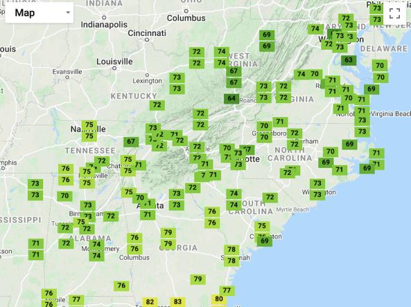
Above-average temperatures were recorded over most of the Southeast. Mean temperatures were in the top five warmest at 27 long-term stations. Maximum temperatures were generally near normal, but minimum temperatures were 1-4 F above normal due to high humidity and cloud cover. Precipitation values ranged from 50% of normal in South Carolina to over 200% of normal in northern Virginia. Several long-term stations observed their wettest summer on record.

Quarterly Climate Impacts and Outlook for the Southeast Region for March – May 2018. Dated June 2018.
Mean temperatures from March through April were at least 2°F below average for over 55% of the 215 long-term (i.e., period of record equaling or exceeding 50 years) stations across the region. A total of 52 long-term stations observed March–April mean temperatures that were ranked within their five coldest values on record.

Quarterly Climate Impacts and Outlook for the Southeast Region for December 2017 – February 2018. Dated March 2018.

Quarterly Climate Impacts and Outlook for the Southeast Region for September – November 2017. Dated December 2017.

Quarterly Climate Impacts and Outlook for the Southeast Region for June – August 2017. Dated September 2017.