Lower Mississippi River Basin Special Drought Webinar
About This Webinar:
Drought conditions continue to impact the Lower Mississippi River Basin, with over 73% of the Lower Mississippi watershed in moderate to extreme drought (D1–D3) and river levels recently hitting record lows in some areas. To provide the latest information on current drought conditions, impacts felt across economic sectors, and short-term and long-range outlooks, NOAA’s National Integrated Drought Information System (NIDIS) in partnership with NOAA’s National Weather Service, the U.S. Army Corps of Engineers, and the U.S. Department of Agriculture, hosted a webinar focused on the drought in the Lower Mississippi River corridor. The goal of the webinar was to raise awareness of the impacts on communities and sectors due to the current low river levels.
Key Webinar Takeaways:
Navigation along the Mississippi River became very difficult, and at times impossible, as the River reached near-record to record-low water levels in September and October 2022. These low river levels were caused by several factors including a multi-year drought in the Missouri River Basin and a more recent ‘flash drought’ in the Ohio River Basin. Recent improvements to drought conditions, along with actions taken by the U.S. Army Corps and the U.S. Coast Guard, have allowed for resumed but restricted navigation in recent weeks. Recent river forecasts suggest river levels will remain low, but not as extreme as was experienced in October while beginning a seasonal rise into winter.
How Did We Get Here? A Look Back at Past Conditions in the Basin
Speaker: Don Duncan, U.S. Army Corp of Engineers
Speaker: Victor Murphy, NOAA National Weather Service (NWS)
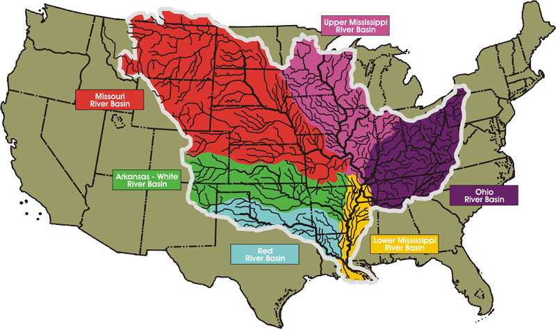
- The Mississippi River Basin covers about 40% of the continental United States.
- 90% of the flow on the Lower Mississippi comes from the Missouri, Ohio, and Upper Mississippi basins, with 60% of the flow at Cairo, IL, coming from the Ohio River Basin.
- May through September is the wettest part of the year for these three basins.
- Climatologically, fall is the season when the Lower Mississippi River is usually at its lowest.
- The 2022 event is similar to those of 2000 and 2012, but not as bad as 1988, which actually bottomed out in July.
- A multi-year drought in the Missouri River Basin over the last 2–3 years has led to below normal flows from St. Louis upstream.
- Short-term drought across the basin since June has reduced flows on the Upper Mississippi and exacerbated ongoing low flows on the Missouri.
- Precipitation from tropical activity was lower and later than expected, even with Hurricane Nicole’s impacts in mid-November. 2022 was the first year since 2016 without a tropical cyclone landfalling in the Gulf of Mexico west of the Florida Panhandle.
- A four to six week “flash drought," or rapid onset drought, in the Ohio River Basin from mid-September to late-October was the final straw in this overall cumulative impact event.
Drought Response Actions
Speaker: COL Andrew Pannier, Deputy Commander, Mississippi Valley Division, U.S. Army Corps of Engineers
- Given current forecasts, the Mississippi Valley Division can maintain a 9-foot channel, even when the Missouri flows drop off, but there will be temporary closures for extended periods of 12 to 72 hours for focused dredging.
- Missouri River flow reductions will begin on November 19; impacts will start on the mainstem Mississippi River around November 29 with full impacts being felt in mid-December.
- At -5.0 ft (St. Louis gage) extended closures due to dredging are expected along the entire reach from St. Louis to Cairo and rock pinnacles become a factor at a stage of -7.0 ft.
- Communication and coordination efforts are integral to the USACE. This includes daily coordination externally, such as with the navigation industry and the U.S. Coast Guard, and internally.
- In addition to efforts to keep the Channel open, such as by dredging, the USACE is also addressing the concerns of a saltwater wedge by constructing an underwater sill in the channel to stop progression of saltwater.
- One area of focus by the USACE is the concern of potential channel obstruction by the underwater rock pinnacles located at River Mile 41–46.
- For more information, visit the the USACE Mississippi Valley Division website.
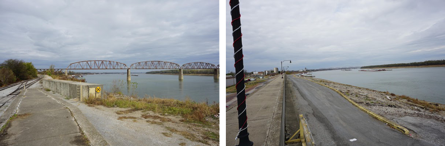
The Mississippi River at Cairo, Illinois in 2011 and 2022
2011 (High Water)
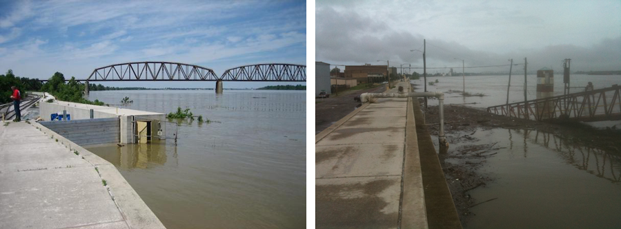
2022 (Low Water)
Where Are We going? Short-Term and Long-Range Outlooks for the Lower Basin
Speaker: Jon Gottschalck, Climate Prediction Center, NOAA/NWS
- La Niña conditions continue in the Pacific Ocean, as shown by both oceanic and atmospheric conditions.
- La Niña is favored to remain in place through the winter 2022–2023.
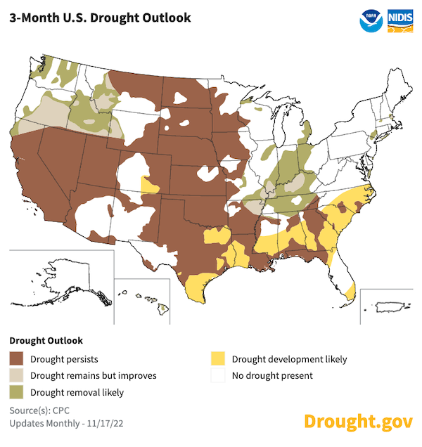
- The winter outlooks show above-normal precipitation is most likely for the northern Rockies, Upper Missouri River Basin, Upper Mississippi River Basin (lower odds), Ohio Valley, and Great Lakes. If verified, this would be favorable for easing drought conditions along the Mississippi River.
- Below-normal precipitation is likely for the southern Plains, far lower Mississippi Valley, and Southeast where drought development is possible by the end of February 2023.
- For more information on climate outlooks, visit the National Weather Service Climate Prediction Center.
Speaker: David Welch, Lower Mississippi River Forecast Center, NOAA/NWS
- The lowest levels on the Mississippi River climatologically occur in October and November. River stages tend to start to increase in December and beyond.
- In fall 2022, historically low water levels were measured at Cairo, IL; Memphis, TN; and Greensville, MS. These exceeded the previous records set in 1988, but did not last as long as the 1988 low river levels.
- Recent precipitation has been average to below average across the basin, but not extremely low. Recent river forecasts suggest river levels will remain low, but not as extreme as was experienced in October while beginning a seasonal rise into winter.
- For information on river forecasts in the Lower Mississippi, visit the Lower Mississippi River Forecast Center. For information on river forecasts in the North Central region, visit the North Central River Forecast Center.
