Drought conditions have improved across Puerto Rico, but have deteriorated across the U.S Virgin Islands.
Key Points
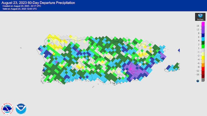
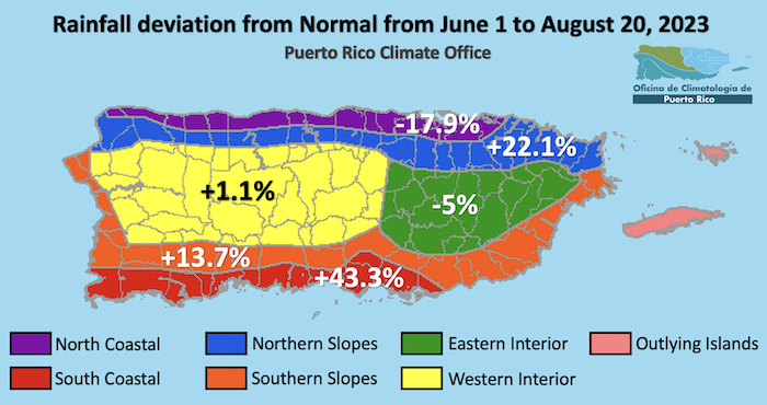
- Puerto Rico Conditions: Over the past 60 days, the southern coast of the island has seen greater than 150% of normal rainfall, removing all drought. Most of the interior and northern coast has seen near-normal to above-normal rainfall. The only exception is the northwest coast, where rainfall deficits of 2–4 inches are common. San Juan has seen near-normal rainfall almost every month and is now at 30.48 inches, or about 3.5 inches below normal year to date (Figure 2).
- U.S. Virgin Islands Conditions: St. Croix and St. Thomas have alternated between severe drought (D2) and extreme drought (D4) since mid-May, as rainfall totals have been dismal all year. St. John has been in moderate drought (D1) most of the spring and summer, with a few weeks of severe drought. On June 29, Rohlsen Airport on St. Croix received 3.19 inches of rain. Despite this precipitation, the year-to-date rain total of 12.24 inches is over 5 inches below the normal of 17.50 inches, making this the 9th driest year to date (YTD) on record in 62 years. St. Thomas’ YTD rainfall of 10.60 inches at Cyril King Airport is the 4th driest in 55 years of data, and a whopping 9.25 inches below normal.
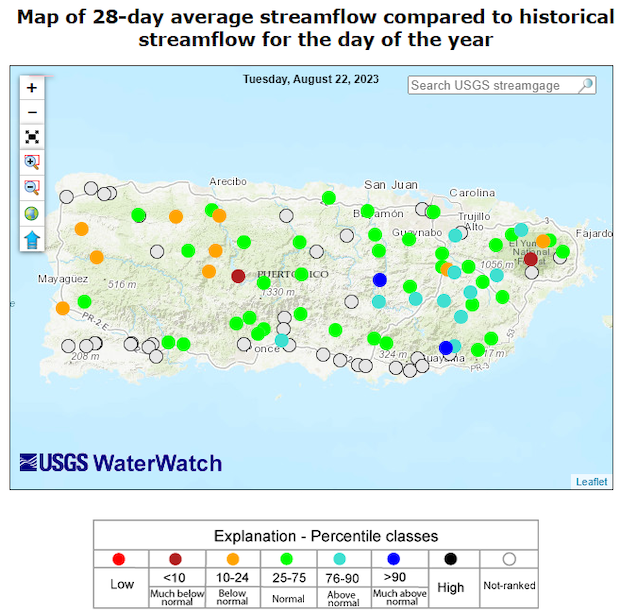
- Puerto Rico Impacts: Most rivers and streamflows in Puerto Rico are near normal, except for the northwest quarter of the island. No major hydrologic impacts are noted (Figure 6).
- U.S. Virgin Islands Impacts: Sporadic rain is occurring but has not been enough to saturate the soil. For example, through August 22, ten of the previous eleven days saw measurable rainfall at Cyril King Airport. However, the total rainfall of 0.89 inch was actually below normal. Farmers and ranchers have reported dry soils and vegetation stress. The combination of dry conditions, reduced access to good grazing, and heat stress have led to livestock losses. Poultry farmers report a continued decrease in egg production.
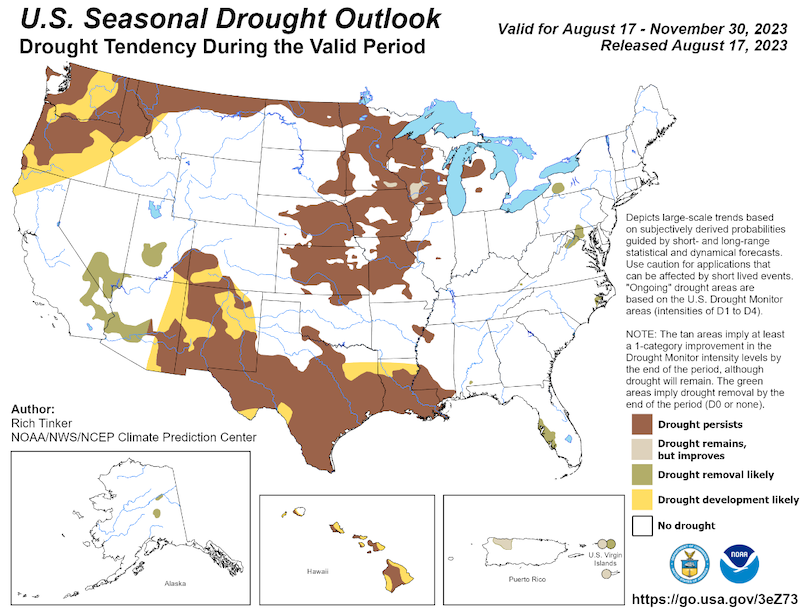
- Looking Ahead: The National Weather Service Climate Prediction Center's seasonal outlook for September through November shows drought improving for all of the USVI and Puerto Rico. The forecast for an above-normal amount of tropical cyclone activity through November is one of the main reasons.
- For weather information specific to your area, please monitor products issued by the National Weather Service in San Juan.
U.S. Drought Monitor map for Puerto Rico, as of August 22, 2023. The U.S. Drought Monitor is updated each Thursday to show the location and intensity of drought across the country.
The map uses 5 classifications: Abnormally Dry (D0), showing areas that may be going into or are coming out of drought, and four levels of drought (D1–D4).
U.S. Drought Monitor map for the U.S. Virgin Islands, as of August 22, 2023. The U.S. Drought Monitor is updated each Thursday to show the location and intensity of drought across the country.
The map uses 5 classifications: Abnormally Dry (D0), showing areas that may be going into or are coming out of drought, and four levels of drought (D1–D4).
U.S. Drought Monitor
D0 - Abnormally Dry
Abnormally Dry (D0) indicates a region that is going into or coming out of drought, according to the U.S. Drought Monitor. View typical impacts by state.
D1 – Moderate Drought
Moderate Drought (D1) is the first of four drought categories (D1–D4), according to the U.S. Drought Monitor. View typical impacts by state.
D2 – Severe Drought
Severe Drought (D2) is the second of four drought categories (D1–D4), according to the U.S. Drought Monitor. View typical impacts by state.
D3 – Extreme Drought
Extreme Drought (D3) is the third of four drought categories (D1–D4), according to the U.S. Drought Monitor. View typical impacts by state.
D4 – Exceptional Drought
Exceptional Drought (D4) is the most intense drought category, according to the U.S. Drought Monitor. View typical impacts by state.
U.S. Drought Monitor map for Puerto Rico, as of August 22, 2023. The U.S. Drought Monitor is updated each Thursday to show the location and intensity of drought across the country.
The map uses 5 classifications: Abnormally Dry (D0), showing areas that may be going into or are coming out of drought, and four levels of drought (D1–D4).
U.S. Drought Monitor map for the U.S. Virgin Islands, as of August 22, 2023. The U.S. Drought Monitor is updated each Thursday to show the location and intensity of drought across the country.
The map uses 5 classifications: Abnormally Dry (D0), showing areas that may be going into or are coming out of drought, and four levels of drought (D1–D4).
The U.S. Drought Monitor is updated weekly on Thursday morning, with data valid through that Tuesday at 7 am Eastern.
The U.S. Drought Monitor is updated weekly on Thursday morning, with data valid through that Tuesday at 7 am Eastern.
Overview
Drought conditions changed little across Puerto Rico in the past two months, and drought remains and continues to fluctuate in the U.S. Virgin Islands. The upcoming wet months and tropical season are expected to improve drought conditions. Drought conditions have remained fairly constant since June, with 8% of Puerto Rico currently in moderate drought (D1) at this time. A small area of severe drought (D2) remains on the northwest coast. In the U.S. Virgin Islands (USVI), conditions continue to fluctuate, with moderate drought (D1) in Saint John, and extreme drought (D3) in Saint Thomas and Saint Croix. This is a 1-category improvement for St. Croix since early June, but a 1-category degradation for St. Thomas. Dry and hot conditions have impacted farming and ranching in the USVI.
Looking Ahead: September, October, and November are the 3 wettest consecutive months of the year for both Puerto Rico and the USVI. Precipitation during these 3 months will be critical for breaking the persistent drought in the USVI. Average rainfall for these 3 months ranges from about 15 inches on St. Croix to 20 inches for St. Thomas. This will be greatly influenced by tropical systems; the updated NOAA Atlantic Basin Tropical Cyclone Outlook for 2023 now calls for above-normal tropical cyclone activity being the most likely outcome. Based mainly on this, the new Seasonal Drought Outlook from the National Weather Service's Climate Prediction Center calls for drought to improve across both Puerto Rico and USVI by the end of November. This represents the first-ever issuance of a Seasonal Drought Outlook for the USVI.
Current and Future Drought Conditions
Drought Conditions
- Puerto Rico: Around 9% of Puerto Rico is currently considered dry or in drought according to the U.S. Drought Monitor, with nearly 7% categorized as Moderate Drought (D1) and nearly 2% categorized as Severe Drought (D2).
- U.S. Virgin Islands: According to the U.S. Drought Monitor, Moderate Drought (D1) is observed across Saint John, and Extreme Drought (D3) across both Saint Thomas and Saint Croix.
Sector Impacts
Agricultural Conditions
- Puerto Rico: Livestock and dairy farmers in the coastal Southwest region of Puerto Rico experienced periods of rain from mid-July until today. The rains have been short-lived, followed by high temperatures (sometimes 98 degrees) causing great evapotranspiration and affecting the growth of pastures. In the coastal south region (Juana Díaz and Coamo municipality), pastures have maintained green on a weekly basis, and no overall abnormally dry conditions have been noticed in the past few weeks.
- Dry spells affected farmers in the central region of Puerto Rico (Naranjito, Comerío, Cidra, and Barranquitas) during some weeks in June. Fruit trees grown in high tunnels experienced stress by lack of water. Plantains and root crops were less affected by dry conditions because farmers incorporated cover crops and maintained weeds on site, which helped retain soil humidity. Even though dry conditions were noted, it has not been worse than other years. Rain episodes occurred throughout mid-July and August, and some farmers reported erosion and landslides in neighboring lands.
- Farmers in the West-Central mountainous region of Puerto Rico (Utuado and Maricao municipality) experienced long periods without rain between June and mid-July. Coffee production was affected even though it is mostly produced in shade. Producers experienced deficiency in coffee shrubs, premature flowering and maturing, and fruit drying before harvest.
- Farmers in the northern region of Puerto Rico (Manatí municipality) reported that June has been the driest and most difficult month to work with by far. Production of greens such as bok choy, arugula, and cress has decreased or lost quality due to heat and hydric stress. They also experienced premature flowering and harvesting periods due to stress.
- All farmers indicated that these past few months, high temperatures made labor and practices more difficult than in other years. To avoid exhaustion and heat stress, farmers limit their work hours to mornings and evenings for both themselves and their crops and animals.
- St. Thomas: Farmers on St.Thomas report that ponds are slowly filling due to sporadic rains. Winds, often above 20 mph, reduced soil moisture. Due to almost-daily concerns about heat (90°F or above) and humidity at or above 75%, and current drought conditions, farmers are planning and preparing irrigation and water efficiency tools to better manage water as part of a longer-term mitigation and conservation plan. Many are considering the use of permaculture and/or tree planting to create shade areas to aid them with soil moisture retention. Specialty and row crop farmers are working to manage water usage by installing gravity-fed irrigation tools and are moving to more drought-tolerant crops to keep production up while still conserving water. Many are still not planting due to drought conditions and are working on land management practices to aid them during non-drought periods. Livestock farmers are rotating livestock.
- St. John: Row and specialty crop farmers on St. John report that recent rains are helping alleviate the dry conditions. However, high winds and excessive heat are reducing soil moisture retention and negatively impacting farmers. Most are currently focusing on microgreens, fruit trees, and quick crops to keep production up and are rotating crops. Most are also preparing land for the wet season, when they hope to increase production and make up for sales that were reduced during the dry season and this current drought.
- St. Croix: Farmers report that recent intermittent showers are not penetrating the soil due to evaporation from high winds. Livestock farmers are working to plan for feed shortages later this summer due to a lack of grass during the hotter months. The Virgin Islands Department of Agriculture (VIDA) is currently buying and storing hay. Growers reported losses of more than 203 livestock along with 20 horses since April. Poultry farmers report that egg production has been reduced by up to 50% due to the heat, and they are concerned because there is little to no Ginney grass and chickens are not eating grain. Extreme heat is increasing water usage for farmers and causing lower egg production during this molting season. Farmers who have poultry, including both broilers and/or egg production, have smaller numbers because they must collect water in containers or use cistern water. Orders of up to 500 chicks have been placed, and farmers are waiting for new arrivals to prepare for production during the cooler climate. VIDA on St. Croix reported in June that they provided more than 1,291,180 gallons of water to farmers in June, 1,020,050 gallons in July, and 903,930 in August. Ranchers are looking for drought mitigation strategies to plan for vegetation distress and land management due to longer-term droughts in recent years.
- Assistance for USVI farmers and ranchers: According to the U.S. Department of Agriculture, St. Croix and St. Thomas already qualified for a 2023 secretarial drought disaster declaration, based on the U.S. Drought Monitor (USDM) depiction. Similarly, livestock producers in St. Croix and St. Thomas qualified for direct assistance through the USDM-driven Livestock Forage Program. LFP assistance begins when severe drought (D2) lasts 8 weeks or more, with payments tripling when the extreme drought (D3) threshold is reached and quadrupling upon spending 4 weeks at D3 or attaining exceptional drought (D4).
Rainfall Trends
Heavy rains over the southern coast of Puerto Rico in the past 60 days resulted in the removal of all drought across the southern part of the island. Some lingering rainfall deficits in the northwest coast contributed to continued moderate to severe drought in this area (Figure 2 and Figure 3).
Soil Moisture Conditions in Puerto Rico
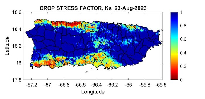
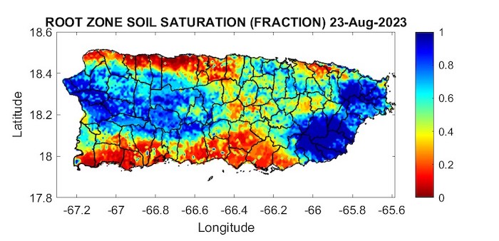
The latest soil moisture data from the Puerto Rico Agricultural Water Management (PRAGWATER) indicates dry soil conditions persist across portions of eastern Puerto Rico and areas of the southwest and northwest coast (Figures 4 and 5).
Streamflow and Reservoir Conditions in Puerto Rico
The real-time 28-day average streamflow from the U.S. Geological Survey (USGS) river gauge network (Figure 6) indicates that, except for the northwest coast, rivers and stream flows are mostly near-normal across the island. View more information on groundwater levels along the South Coast of Puerto Rico.
Outlooks
Rainfall Outlook
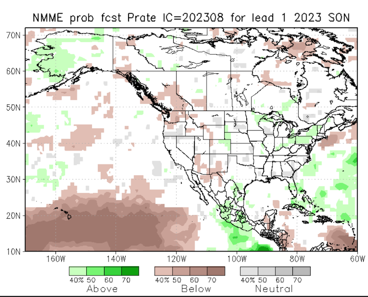
In accordance with the Seasonal Drought Outlook (Figure 1) from the National Weather Service's Climate Prediction Center, the latest North American Multi-Model Ensemble (NMME) shows a strong likelihood of normal to above normal rainfall for the Greater Antilles during the fall (Figure 7).
For More Information
- National Weather Service (NWS) Weather Forecast Office – San Juan: Climate and Drought Information
- NWS Drought Information Statements for Puerto Rico and the U.S. Caribbean
- Drought.gov:
- Caribbean Drought Bulletins. Caribbean Regional Climate Center, Caribbean Institute for Meteorology and Hydrology (CIMH), Barbados
- U.S. Department of Agriculture (USDA) Caribbean Climate Hub drought and disaster assistance resources for tropical forestry and agriculture
Prepared By
Odalys Martinez and Emanuel Rodriguez
National Weather Service Weather Forecast Office – San Juan
Héctor J. Jiménez
Office of Climatology, University of Puerto Rico
Meredith Muth
NOAA/National Integrated Drought Information System (NIDIS)
Victor Murphy
National Weather Service Southern Region
Christina Chanes
University of Virgin Islands
Silmarie Crespo Vélez and Nora Álvarez-Berríos
USDA Caribbean Climate Hub, USFS International Institute of Tropical Forestry
Brad Rippey
USDA Office of the Chief Economist
Timothy Dalrymple
USGS Caribbean - Florida Water Science Center (CFWSC)
Puerto Rico Reporting Input: Thanks to the Agricultural Extension Service, College of Agricultural Sciences, University of Puerto Rico-Mayaguez. Special thanks to Dr. Luis Alexis Rodríguez-Cruz, agronomists and farmers: Gabriela Álvarez, Harry Ramírez, Josué Rivera, Merari Torres Amaro, Miguel Fonseca, Samuel Rodriguez-Rodriguez, and others.
USVI Reporting Input: Several individuals contributed to this report and we are acknowledging the following for their support including the farming community across the USVI, UVI faculty, staff, and collaborators of the UVI School of Agriculture, UVI Physics Program, UVI Etelman Observatory, UVI Agricultural Experiment Station, VI Department of Agriculture, as well as the USDA Office Chief Economist, National Parks Service in St. Croix, VI Department of Planning and Natural Resources, USDA Farm Service Agency, Coral Bay Community Council and the many volunteer drought reporters and farmers from across the territory.
About This Report
This drought update is issued in partnership between the National Integrated Drought Information System (NIDIS), National Oceanic and Atmospheric Administration (NOAA) National Weather Service, the U.S. Department of Agriculture (USDA), and the University of the Virgin Islands. The purpose of the update is to communicate a potential area of concern for drought expansion and/or development within Puerto Rico and the U.S. Virgin Islands based on recent conditions and the upcoming three-month forecast.
NIDIS and its partners will issue these updates every two months. Subscribe for these U.S. Caribbean drought updates here.


