Below-normal precipitation was observed across the islands since December 1, resulting in drought deterioration for Puerto Rico and continued drought across St. Thomas and St. Croix in the U.S. Virgin Islands.
Drought conditions are expected to persist as the dry season continues across the northeastern Caribbean.
Key Points
- Puerto Rico Conditions: During the past 60 days, almost all of Puerto Rico has observed below-normal precipitation. In fact, most of the interior as well as Vieques and Culebra have only collected 25% to 50% of normal, while the northwest only saw 10% to 25% of normal. 91% of the island is either in drought or experiencing Abnormally Dry (D0) conditions, with 39% of the west and interior island classified as Moderate Drought (D1) and 52% as Abnormally Dry (D0). The main climate site at the Luis Muñoz Marín International Airport collected 13.54 inches from November 1 to January 15, or about 95% of normal. Most of this rainfall was reported in November and the first half of December 2023, but significant rainfall events have been absent since then. In contrast, parts of the municipalities of Ponce and Juana Diaz, along the southern coast, have seen less than 2 inches of rain since November 1. For the eastern Caribbean, the beginning of the year is also the onset of the dry season, which should last until early or mid-April.
- U.S. Virgin Islands (USVI) Conditions: For the past 60 days, rainfall amounts ranged from 2 to 6 inches across St. Croix, 4 to 6 inches in St. Thomas, and 2 to 5 inches in St. John. The rains in St. Croix this past November allowed for one-class improvement in the U.S. Drought Monitor, from Severe (D2) to a Moderate Drought (D1) classification. However, D2 conditions prevail in St. Thomas. The island of St. John remains free of dryness or drought.
- Puerto Rico Impacts: Dry, windy, and hot conditions are starting to lead to dry soils and vegetation in parts of the island, with fires reported. These dry conditions are also helping with land preparation for upcoming planting in some areas.
- U.S. Virgin Islands (USVI) Impacts: High winds and few rains are causing a loss in soil moisture, and the vegetation is starting to show signs of stress. Water access and poultry production are also negatively impacted.
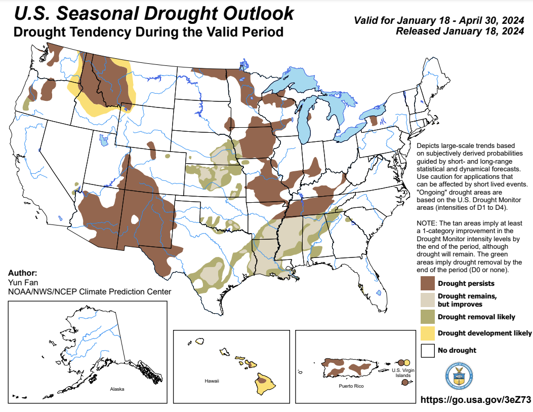
- Looking Ahead: The National Weather Service Climate Prediction Center's seasonal outlook calls for drought to persist in Puerto Rico, St. Croix, and St. Thomas. Drought development in St. John is likely.
- For weather information specific to your area, please monitor products issued by the National Weather Service in San Juan.
- View active National Weather Service Drought Information Statements, including for Puerto Rico and the U.S. Virgin Islands.
See below for additional details on rainfall, soil moisture, and streamflow conditions, impacts, and outlooks.
U.S. Drought Monitor map for Puerto Rico, as of January 16, 2024. The U.S. Drought Monitor is updated each Thursday to show the location and intensity of drought across the country.
The map uses 5 classifications: Abnormally Dry (D0), showing areas that may be going into or are coming out of drought, and four levels of drought (D1–D4).
U.S. Drought Monitor map for the U.S. Virgin Islands, as of January 16, 2024. The U.S. Drought Monitor is updated each Thursday to show the location and intensity of drought across the country.
The map uses 5 classifications: Abnormally Dry (D0), showing areas that may be going into or are coming out of drought, and four levels of drought (D1–D4).
U.S. Drought Monitor
D0 - Abnormally Dry
Abnormally Dry (D0) indicates a region that is going into or coming out of drought, according to the U.S. Drought Monitor. View typical impacts by state.
D1 – Moderate Drought
Moderate Drought (D1) is the first of four drought categories (D1–D4), according to the U.S. Drought Monitor. View typical impacts by state.
D2 – Severe Drought
Severe Drought (D2) is the second of four drought categories (D1–D4), according to the U.S. Drought Monitor. View typical impacts by state.
D3 – Extreme Drought
Extreme Drought (D3) is the third of four drought categories (D1–D4), according to the U.S. Drought Monitor. View typical impacts by state.
D4 – Exceptional Drought
Exceptional Drought (D4) is the most intense drought category, according to the U.S. Drought Monitor. View typical impacts by state.
U.S. Drought Monitor map for Puerto Rico, as of January 16, 2024. The U.S. Drought Monitor is updated each Thursday to show the location and intensity of drought across the country.
The map uses 5 classifications: Abnormally Dry (D0), showing areas that may be going into or are coming out of drought, and four levels of drought (D1–D4).
U.S. Drought Monitor map for the U.S. Virgin Islands, as of January 16, 2024. The U.S. Drought Monitor is updated each Thursday to show the location and intensity of drought across the country.
The map uses 5 classifications: Abnormally Dry (D0), showing areas that may be going into or are coming out of drought, and four levels of drought (D1–D4).
The U.S. Drought Monitor is updated weekly on Thursday morning, with data valid through that Tuesday at 7 am Eastern.
The U.S. Drought Monitor is updated weekly on Thursday morning, with data valid through that Tuesday at 7 am Eastern.
Current and Future Drought Conditions
Drought Conditions
- Puerto Rico: According to the U.S. Drought Monitor, 91% of the island is either in drought or experiencing Abnormally Dry (D0) conditions, with 39% of the island classified as Moderate Drought (D1) and 52% as Abnormally Dry (D0).
- U.S. Virgin Islands: According to the U.S. Drought Monitor, St. Thomas is in Severe Drought (D2) and St. Croix is in Moderate Drought (D1). St. John remains drought-free.
Sector Impacts
Agricultural Conditions
- Puerto Rico:
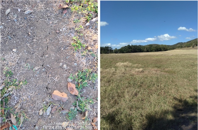
- In the Central and Metropolitan Region (Caguas, San Juan), farmers report intermittent rain. Some have been taking advantage of the conditions to prepare land for a new crop rotation and farming season. Some have seen cracks in the ground, which is an indicator of low soil moisture.
- Ranchers and farmers in the Southwest Region (Cabo Rojo, Guanica, Lajas) experienced notable wind and dry patterns in the area. Fire was reported at a forest in the Cabo Rojo Municipality. There have been drought patterns for the past two months, and on some days temperatures surpassed 90°F. Some farmers haven’t received rain for 2 weeks, and forage and vegetation health deteriorated. A farmer hasn’t reached the expected yield for the watermelon (Cucumis melo) crop this season.
- In the South Region (Yauco, Coamo, Juana Díaz), some farmers indicated that little to no rain has fallen for approximately 2 weeks. Landowners in the Juana Díaz and Coamo municipality reported the rain has been intermittent. The ground has started to crack, and little dew has been spotted in the mornings. Crops have been irrigated. Vegetation appears drier and with a brown-ish color. Forest fires and burnt vegetation were seen throughout the month.
- Farmers from the Central Region (Las Marias, Utuado) noted that it rains daily but in short quantities. The soil seems dry and hard, and cracks were spotted in the farm land. Intense heat was also present and affected vegetable production.
- In the northern region (Toa Alta), a farmer has not received significant rain for 3 weeks. It has been beneficial for production. Pastures are still green and springs maintain good flow, but the ground is quite dry.
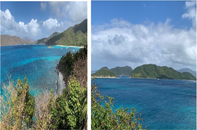
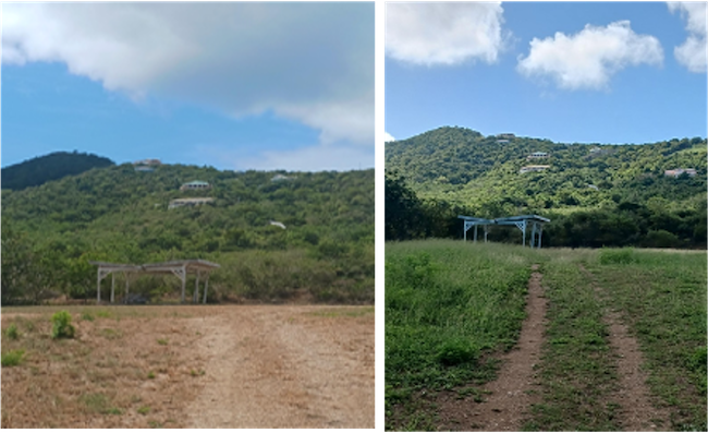
- St. Thomas: Farmers are reporting that while ponds are evaporating, the limited and sporadic rain is helping them to slowly recharge. Farmers are also reporting high wind conditions, which is reducing soil moisture, adding to issues farmers face. Many farmers are planting and are working on land management practices to aid them during non-drought periods. They are currently planting orchards and fruit trees due to the heat. Livestock farmers are rotating livestock and separating males and females to reduce births due to a lack of forage on their land. Also, livestock farmers are buying grain and hay to ensure they have forage for their animals.
- St. John: Row and specialty crop farmers on St. John report they have had rain and are now bouncing back from earlier dry conditions. Soil moisture is being lost due to high winds and dry conditions. Most are currently rotating crops and focusing on microgreens, fruit trees, and quick crops to keep production up. Recent rains are helping with land preparation to increase production and make up for sales lost during the recent drought.
- St. Croix: Farmers have seen sporadic rain, and many farmers report that these intermittent showers are not penetrating the soil due to evaporation from high winds. Livestock farmers are working to plan for feed shortages, which will likely occur later in the year due to a lack of grass during the hotter months. Ranchers are seriously looking for drought mitigation strategies to plan for vegetation distress and land management due to longer-term droughts in recent years. Poultry farmers are now indicating that egg production, while previously reduced by more than 50% due to the heat, has increased due to cooler weather. Farmers who have poultry, including both broilers and/or egg laying hens, have smaller numbers because they must collect water in containers or use cistern water for the poultry during this heat.
- Assistance for USVI farmers and ranchers: According to the U.S. Department of Agriculture, St. Croix and St. Thomas already qualified for a 2023 secretarial drought disaster declaration, based on the U.S. Drought Monitor (USDM). Similarly, livestock producers in St. Croix and St. Thomas qualified for direct assistance through the USDM-driven Livestock Forage Program (LFP). LFP assistance begins when Severe Drought (D2) lasts 8 weeks or more, with payments tripling when the Extreme Drought (D3) threshold is reached, and quadrupling upon spending 4 weeks at D3 or attaining Exceptional Drought (D4).
Rainfall Trends
The driest part of Puerto Rico was La Sierra de Luquillo in the northeast, with 60-day rainfall deficits of 8–12 inches and isolated spots of deficits up to 15 inches. 60-day rainfall deficits of 6–12 inches were also widespread along the coastal municipalities in the northwest, from Arecibo westward. Elsewhere, widespread deficits of 4–8 inches were noted across most of the interior of the island, with Vieques and Culebra seeing 2–4 inches below average.


Soil Moisture Conditions in Puerto Rico
The latest soil moisture data from the Puerto Rico Agricultural Water Management (PRAGWATER) indicates that soils are drying out along the eastern interior, from Coamo to Juncos. It is also dry in the southern slopes, from Guayama westward to Cabo Rojo, and in the northwest, from Rincon eastward into Arecibo. The western interior is also drying out, but the situation is less severe (Figures 3 and 4).


Streamflow and Groundwater Conditions in Puerto Rico
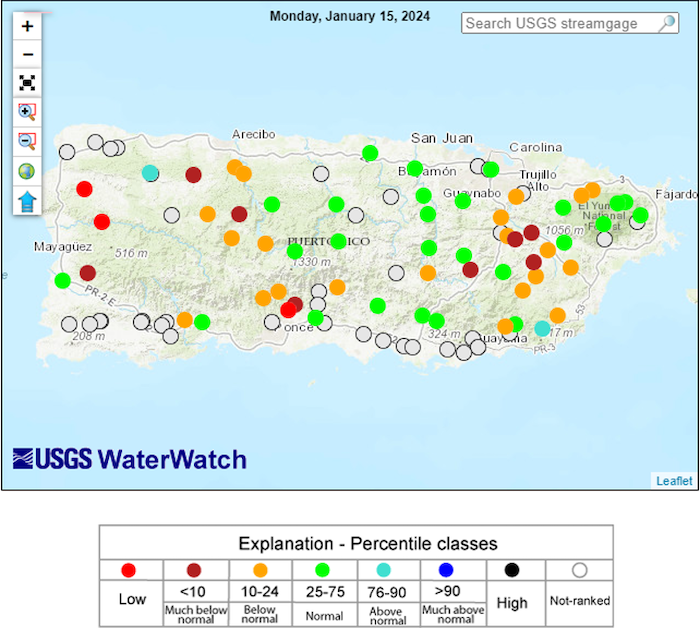
The real-time 28-day average streamflow from the U.S. Geological Survey (USGS) river gauge network (Figure 5) indicates streams running below normal (10th–24th percentile of historical conditions) to much below normal (less than 10th percentile) across the western half, eastern interior, and south of Puerto Rico. View information on groundwater levels along the South Coast of Puerto Rico.
Outlooks
Seasonal Drought Outlook
The Seasonal Drought Outlook (Figure 6) calls for persistent drought conditions across the eastern interior, southwest, and northwest of Puerto Rico. Drought conditions are also expected to continue across St. Thomas and St. Croix in the U.S. Virgin Islands, while it is likely that drought conditions will develop across St. John as we move into the dry season.
For More Information
- National Weather Service (NWS) Weather Forecast Office – San Juan: Climate and Drought Information
- NWS Drought Information Statements for Puerto Rico and the U.S. Caribbean
- Drought.gov:
- Caribbean Drought Bulletins. Caribbean Regional Climate Center, Caribbean Institute for Meteorology and Hydrology (CIMH), Barbados
- U.S. Department of Agriculture (USDA) Caribbean Climate Hub drought and disaster assistance resources for tropical forestry and agriculture
Prepared By
Emanuel Rodriguez and Odalys Martinez
National Weather Service San Juan Weather Forecast Office
Héctor J. Jiménez
Office of Climatology, University of Puerto Rico
Meredith Muth
NOAA National Integrated Drought Information System (NIDIS)
Victor Murphy
National Weather Service Southern Region
Christina Chanes
University of Virgin Islands
Silmarie Crespo Vélez and Nora Álvarez-Berríos
USDA Caribbean Climate Hub, USFS International Institute of Tropical Forestry
Brad Rippey
USDA Office of the Chief Economist
Timothy Dalrymple
USGS Caribbean – Florida Water Science Center (CFWSC)
Puerto Rico Reporting Input: Thanks to the Agricultural Extension Service, College of Agricultural Sciences, University of Puerto Rico-Mayaguez, South West Soil and Water Conservation District, and the Association of Cattle Ranchers. Special thanks to agronomists, ranchers, and farmers: Adrián Vázquez Bandas, Ian Pagán Roig, Isela Ortiz, Merari Torres Amaro, Juan Vélez Velázquez.
USVI Reporting Input: Several individuals contributed to this report and we are acknowledging the following for their support including the farming community across the USVI, UVI faculty, staff, and collaborators of the UVI School of Agriculture, UVI Physics Program, UVI Etelman Observatory, UVI Agricultural Experiment Station, VI Department of Agriculture, as well as the USDA Office Chief Economist, National Parks Service in St. Croix, VI Department of Planning and Natural Resources, USDA Farm Service Agency, Coral Bay Community Council and the many volunteer drought reporters and farmers from across the territory.
About This Report
This drought update is issued in partnership between the National Integrated Drought Information System (NIDIS), National Oceanic and Atmospheric Administration (NOAA) National Weather Service, the U.S. Department of Agriculture (USDA), and the University of the Virgin Islands. The purpose of the update is to communicate a potential area of concern for drought expansion and/or development within Puerto Rico and the U.S. Virgin Islands based on recent conditions and the upcoming three-month forecast.
NIDIS and its partners will issue these updates every two months. Subscribe for these U.S. Caribbean drought updates here.


