Beneficial rains were observed since February 1 across portions of the territories, causing drought conditions to relax in Puerto Rico and in the U.S. Virgin Islands.
Although some dryness and drought conditions persist in other areas, the northeastern Caribbean is moving into the start of its wet season, and drought conditions are expected to improve further.
Key Points
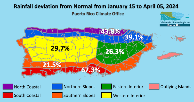
- Puerto Rico Conditions: Puerto Rico observed beneficial rains over the past 60 days across most of the island, with only the northwest coast and southeast coast seeing below-normal rainfall. Parts of the southern coast and central interior saw more than 200% of normal rainfall during this period. In the areas with the heaviest amount of rain observed, the rivers, soil, vegetation, and water reservoirs responded, and drought conditions showed improvement during this period. However, the areas that received the least amount of rain remained Abnormally Dry (D0) or in Moderate (D1) drought. The amount of the island in Moderate Drought fell from 40% in late February to only 6.6% in early April. Moderate Drought was confined to the northwest coast and near El Yunque in eastern Puerto Rico. Luis Muñoz Marín International Airport in San Juan has seen 14.03 inches of rain so far this year, or about 140% of the normal of 9.92 inches. Generally, April is a period of transition between the dry winter months and the onset of the early wet season that begins in late May.
- U.S. Virgin Islands (USVI) Conditions: The dry season was also generous with the Virgin Islands, as nearly a foot of rain was observed in Saint Croix in the past two months. In the same time period, almost 10 inches of rain were observed in St. Thomas. During the month of February, Windswept Beach in St. John saw 5.66 inches, which is a record wet total for the month there, dating back to 1984. These pulses of rain allowed for significant improvement across the islands, with St. Croix and St. John being declared free of drought, and Abnormally Drought (D0) conditions persisting in St. Thomas.
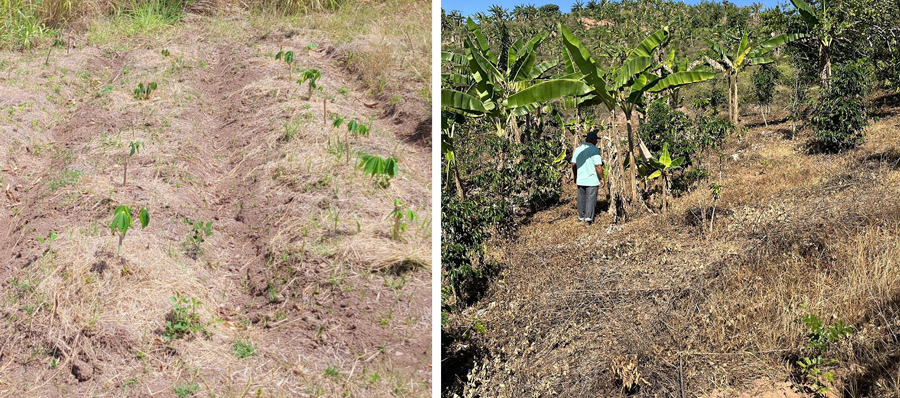
- Puerto Rico Impacts: Farmers in the northwestern regions reported rain on their farms in February, then very few rains for the following weeks. Some northwestern farms have resorted to manually watering their crops, which delays other tasks on the farm. The dry conditions along with the high temperatures reported pose a risk for the well-being of workers, who have chosen to finish tasks earlier to protect themselves from the heat. In the southwest region, farmers experienced periods of rain and intense winds in February, followed by both dry days and days with light drizzle in March and April. Livestock farmers did not report drought-related impacts. For the southern regions, land managers experienced a range of conditions and recent dryness is impacting vegetation. For the central, northeastern and eastern mountainous regions, rains and high temperatures have occurred over the past few months. Farmers in the southeast region report dry and hot conditions.
- U.S. Virgin Islands (USVI) Impacts: Farmers across the USVI stated that while light rain helps, it can also give a false impression. The rain is just enough to quickly allow vegetation to bounce back, but then the vegetation dries out again very quickly due to heat and high winds. Some vegetation is showing signs of distress, including soil cracking. Livestock farmers have indicated they are still surveilling Bont Ticks in Lower Love on St. Croix on two farms. In addition, poultry farmers across the USVI are reporting a decrease in egg production due to recent heat waves and winds, which have given them less access to water and vegetation for feed. Poultry farmers are currently using grain due to a consistent lack of access to vegetation and hay. Overall, farmers have indicated that due to losses last year, prices for eggs have surged by more than 25% due to demand and increased production costs.
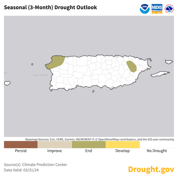
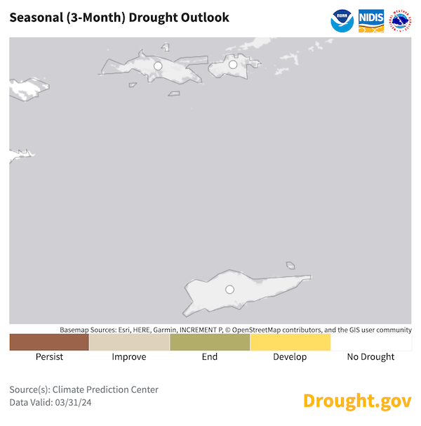
- Looking Ahead: The NWS Climate Prediction Center's seasonal outlook calls for drought conditions to disappear in Puerto Rico, as well as the U.S. Virgin Islands.
- For weather information specific to your area, please monitor products issued by the National Weather Service in San Juan.
- View active National Weather Service Drought Information Statements, including for Puerto Rico and the U.S. Virgin Islands.
See below for additional details on rainfall, soil moisture, and streamflow conditions, impacts, and outlooks.
U.S. Drought Monitor map for Puerto Rico, as of April 9, 2024. The U.S. Drought Monitor is updated each Thursday to show the location and intensity of drought across the country.
The map uses 5 classifications: Abnormally Dry (D0), showing areas that may be going into or are coming out of drought, and four levels of drought (D1–D4).
U.S. Drought Monitor map for the U.S. Virgin Islands, as of April 9, 2024. The U.S. Drought Monitor is updated each Thursday to show the location and intensity of drought across the country.
The map uses 5 classifications: Abnormally Dry (D0), showing areas that may be going into or are coming out of drought, and four levels of drought (D1–D4).
A drought index combines multiple drought indicators (e.g., precipitation, temperature, soil moisture) to depict drought conditions. For some products, like the U.S. Drought Monitor, authors combine their analysis of drought indicators with input from local observers. Other drought indices, like the Standardized Precipitation Index (SPI), use an objective calculation to describe the severity, location, timing, and/or duration of drought.
Learn MorePeriods of drought can lead to inadequate water supply, threatening the health, safety, and welfare of communities. Streamflow, groundwater, reservoir, and snowpack data are key to monitoring and forecasting water supply.
Learn MoreDrought can reduce the water availability and water quality necessary for productive farms, ranches, and grazing lands, resulting in significant negative direct and indirect economic impacts to the agricultural sector. Monitoring agricultural drought typically focuses on examining levels of precipitation, evaporative demand, soil moisture, and surface/groundwater quantity and quality.
Learn MoreA drought index combines multiple drought indicators (e.g., precipitation, temperature, soil moisture) to depict drought conditions. For some products, like the U.S. Drought Monitor, authors combine their analysis of drought indicators with input from local observers. Other drought indices, like the Standardized Precipitation Index (SPI), use an objective calculation to describe the severity, location, timing, and/or duration of drought.
Learn MorePeriods of drought can lead to inadequate water supply, threatening the health, safety, and welfare of communities. Streamflow, groundwater, reservoir, and snowpack data are key to monitoring and forecasting water supply.
Learn MoreDrought can reduce the water availability and water quality necessary for productive farms, ranches, and grazing lands, resulting in significant negative direct and indirect economic impacts to the agricultural sector. Monitoring agricultural drought typically focuses on examining levels of precipitation, evaporative demand, soil moisture, and surface/groundwater quantity and quality.
Learn MoreU.S. Drought Monitor
D0 - Abnormally Dry
Abnormally Dry (D0) indicates a region that is going into or coming out of drought, according to the U.S. Drought Monitor. View typical impacts by state.
D1 – Moderate Drought
Moderate Drought (D1) is the first of four drought categories (D1–D4), according to the U.S. Drought Monitor. View typical impacts by state.
D2 – Severe Drought
Severe Drought (D2) is the second of four drought categories (D1–D4), according to the U.S. Drought Monitor. View typical impacts by state.
D3 – Extreme Drought
Extreme Drought (D3) is the third of four drought categories (D1–D4), according to the U.S. Drought Monitor. View typical impacts by state.
D4 – Exceptional Drought
Exceptional Drought (D4) is the most intense drought category, according to the U.S. Drought Monitor. View typical impacts by state.
U.S. Drought Monitor
D0 - Abnormally Dry
Abnormally Dry (D0) indicates a region that is going into or coming out of drought, according to the U.S. Drought Monitor. View typical impacts by state.
D1 – Moderate Drought
Moderate Drought (D1) is the first of four drought categories (D1–D4), according to the U.S. Drought Monitor. View typical impacts by state.
D2 – Severe Drought
Severe Drought (D2) is the second of four drought categories (D1–D4), according to the U.S. Drought Monitor. View typical impacts by state.
D3 – Extreme Drought
Extreme Drought (D3) is the third of four drought categories (D1–D4), according to the U.S. Drought Monitor. View typical impacts by state.
D4 – Exceptional Drought
Exceptional Drought (D4) is the most intense drought category, according to the U.S. Drought Monitor. View typical impacts by state.
U.S. Drought Monitor map for Puerto Rico, as of April 9, 2024. The U.S. Drought Monitor is updated each Thursday to show the location and intensity of drought across the country.
The map uses 5 classifications: Abnormally Dry (D0), showing areas that may be going into or are coming out of drought, and four levels of drought (D1–D4).
U.S. Drought Monitor map for the U.S. Virgin Islands, as of April 9, 2024. The U.S. Drought Monitor is updated each Thursday to show the location and intensity of drought across the country.
The map uses 5 classifications: Abnormally Dry (D0), showing areas that may be going into or are coming out of drought, and four levels of drought (D1–D4).
The U.S. Drought Monitor is updated weekly on Thursday morning, with data valid through that Tuesday at 7 am Eastern.
The U.S. Drought Monitor is updated weekly on Thursday morning, with data valid through that Tuesday at 7 am Eastern.
A drought index combines multiple drought indicators (e.g., precipitation, temperature, soil moisture) to depict drought conditions. For some products, like the U.S. Drought Monitor, authors combine their analysis of drought indicators with input from local observers. Other drought indices, like the Standardized Precipitation Index (SPI), use an objective calculation to describe the severity, location, timing, and/or duration of drought.
Learn MorePeriods of drought can lead to inadequate water supply, threatening the health, safety, and welfare of communities. Streamflow, groundwater, reservoir, and snowpack data are key to monitoring and forecasting water supply.
Learn MoreDrought can reduce the water availability and water quality necessary for productive farms, ranches, and grazing lands, resulting in significant negative direct and indirect economic impacts to the agricultural sector. Monitoring agricultural drought typically focuses on examining levels of precipitation, evaporative demand, soil moisture, and surface/groundwater quantity and quality.
Learn MoreA drought index combines multiple drought indicators (e.g., precipitation, temperature, soil moisture) to depict drought conditions. For some products, like the U.S. Drought Monitor, authors combine their analysis of drought indicators with input from local observers. Other drought indices, like the Standardized Precipitation Index (SPI), use an objective calculation to describe the severity, location, timing, and/or duration of drought.
Learn MorePeriods of drought can lead to inadequate water supply, threatening the health, safety, and welfare of communities. Streamflow, groundwater, reservoir, and snowpack data are key to monitoring and forecasting water supply.
Learn MoreDrought can reduce the water availability and water quality necessary for productive farms, ranches, and grazing lands, resulting in significant negative direct and indirect economic impacts to the agricultural sector. Monitoring agricultural drought typically focuses on examining levels of precipitation, evaporative demand, soil moisture, and surface/groundwater quantity and quality.
Learn MoreCurrent and Future Drought Conditions
Drought Conditions
- Puerto Rico: According to the U.S. Drought Monitor, 15.2% of Puerto Rico is experiencing Abnormally Dry (D0) conditions, while 6.6% is under a Moderate Drought (D1).
- U.S. Virgin Islands: According to the U.S. Drought Monitor, St. Thomas remains under Abnormally Dry (D0) conditions, while St. Croix and St. John are currently free of drought or dryness.
Sector Impacts
To report the effects of dry conditions on your farm projects for future Drought Updates, use the Drought Condition Monitoring Observations and Reports (CMOR) tool or join the Caribbean Climate Hub reporter group chat.
Agricultural Conditions
- Puerto Rico:
- In the western region (Mayagüez, Cabo Rojo, Añasco), observers reported heavy drizzle and winds in the first week of February. Cilantro producers were concerned about how the rain could affect their production. Farmers reported hot conditions for the month of March.
- In the mountainous western region (Las Marías, Utuado, Moca), farmers reported light drizzles in recent months. Cool and sunny conditions were reported in mid-February compared to previous weeks. For the month of March, dry and hot conditions continued, delaying the growth of some crops or vegetative barriers. A farmer has received almost no rain on his property. Since he does not have an irrigation system, he has had to water his crops using a back-mounted sprinkler pump. A farmer in Moca reports yellowing of breadfruit leaves and that he has to prioritize manual irrigation, slowing other tasks in operation. Some farmers have had to end farm chores earlier to avoid excessive heat and dry conditions. For the municipality of Utuado, weather conditions have been reported in line with the season.
- Farmers in the southwest region (Yauco, Guánica, Lajas, San German) experienced little to no rain by the end of January. Observers reported drizzle during the first week of February for Guánica, Yauco, and Lajas, where one farmer even reported 1.4 inches of rain in one day. Even so, in the last 3 months, farmers and service providers noticed deterioration in plantains, banana, passion fruit, and papaya farms due to dry conditions. Strong winds were reported in the mountainous part of Yauco. For the month of March, rain was reported in the afternoons in the municipality of Yauco, with little rain for a farm in San German. As for the dairy sector, while the temperatures have been unusually hot for this time of the year, a rancher reports consistent drizzles in the afternoon that are keeping the pasture greens. According to this rancher, the dairy farms between Guanica and Lajas are not in drought conditions at the moment.
- Field managers in the southern region (Coamo, Juana Diaz, Guayama) have experienced dry conditions, passing showers, winds, and heat for January and February. Fires were reported in grasslands for Salinas, Santa Isabel, and Guayama. Field managers also reported semi-humid soil conditions and mentioned that the conditions this March are more humid than March 2023. Recently, there has been rapid evaporation of water in the soil, and trees have lost turgidity in the leaves and needed irrigation. The grass is beginning to dry and turn brown.
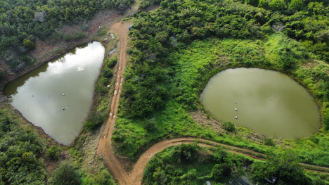
- As for the northern region, (San Juan, Bayamón, Toa Baja, Manatí, Vega Baja, Morovis) the driest period for farmers in Toa Baja and Vega Baja were the first 3–4 weeks of January (a farm in Toa Baja received 4.16 inches that month). In Vega Baja, leaf crops (lettuce, arugula) experienced germination problems and loss of turgor due to heat and dry conditions. Farmers have been able to deal with dry conditions using water catchment ponds and water reserves on the land. The first week of February brought heavy rains to some northern municipalities. Above-normal hot conditions were reported in March. For Vega Baja, cilantro growers experienced heavy rains that affected the cultivation of cilantro, while lands in Manatí continued with unusually dry conditions.
- For the central region (Cidra, Barranquitas, Naranjito), farmers report intermittent rain conditions over the last few months. Some mention that there can be several days of rain and several days or a week of sun, and they alternate throughout the weeks. In Naranjito and Barranquitas the heat has intensified, and workers have resorted to ceasing work at 11 a.m. and resuming work in the afternoon when the temperature decreases.
- In the eastern region (Caguas, Las Piedras, Yabucoa, San Lorenzo, Vieques), farmers have reported some intermittent and varied rains in recent months. In general, dry conditions and intense sun have dominated the past months. Farmers in San Lorenzo reported that even though there have been very few rain events, they have been intense, and farmers have been using those conditions to sow tuber crops. Farmers in Yabucoa have reported no rain in the past weeks. Dry conditions have been constant in the island municipality of Vieques with frequent soil humidity loss. High heat is a concern for farmers in terms of worker safety and agricultural production. Grazing in cattle farms has been limited. In addition to the lack of water, service providers mention that overgrazing of areas can worsen pasture conditions and recommend grazing rotation.
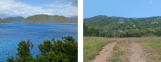
- St. Thomas: Farmers are reporting that ponds are beginning to evaporate. Soil cracking has been seen by farmers who state that limited and sporadic rain helped the ponds to slowly recharge, but as the heat ramps up, evaporation is a cause for concern. Farmers are also reporting windy weather daily. This is adding to issues farmers in the region face due to evaporation with limited soil moisture. Farmers are planting and working on land management practices to aid them during non-drought periods. They are currently planting fruit trees and preparing crops for the hotter months. Many farmers are using grass on their property and are buying grain to supplement livestock feed. Also, it should be noted that a 50-pound sack of grain has risen in price by approximately $3–$5 dollars per bag.
- St. John: Row and specialty crop farmers on St. John are reporting that they have had rain and are reporting improved conditions. However, the ground is quite dry with heat and wind hampering gains as vegetation is showing signs of distress. Farmers indicate the soil is dry due to high winds—often over 20 MPH—impacting soil moisture. Most are currently focusing on microgreens, fruit trees, and quick crops to keep production up and are rotating crops. Most are preparing land so that they can increase production.
- St. Croix: Farmers have seen sporadic rain, and many farmers are reporting these intermittent showers are not penetrating the soil due to evaporation from high winds. Currently, livestock farmers are working to plan for feed shortages, which will occur later in the year due to a lack of grass during the hotter months. Many are also buying grain to supplement their feed. Poultry farmers are now indicating that egg production, while previously reduced by more than 50% due to the heat, had slightly increased due to cooler weather. However, with temperatures rising, poultry farmers are seeing a rapid decrease in egg production. The U.S. Virgin Islands Department of Agriculture (VIDA) reported water deliveries in St. Croix of 739,715 gallons in January, 656,730 in February, and more than 864,720 gallons in March.
- Assistance for USVI farmers and ranchers: According to the U.S. Department of Agriculture, St. Croix and St. Thomas already qualified for a 2023 secretarial drought disaster declaration, based on the U.S. Drought Monitor (USDM). Similarly, livestock producers in St. Croix and St. Thomas qualified for direct assistance through the USDM-driven Livestock Forage Program (LFP). LFP assistance begins when Severe Drought (D2) lasts 8 weeks or more, with payments tripling when the Extreme Drought (D3) threshold is reached, and quadrupling upon spending 4 weeks at D3 or attaining Exceptional Drought (D4).

Rainfall Trends
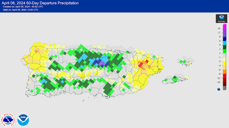
Over the past 60 days, most of Puerto Rico received above-average rainfall. The north-central portion received 2 to 6 inches above normal, In contrast, the northwest coast and parts of the eastern one-fourth of the island observed deficits of 2 to 4 inches.
Soil Moisture Conditions in Puerto Rico
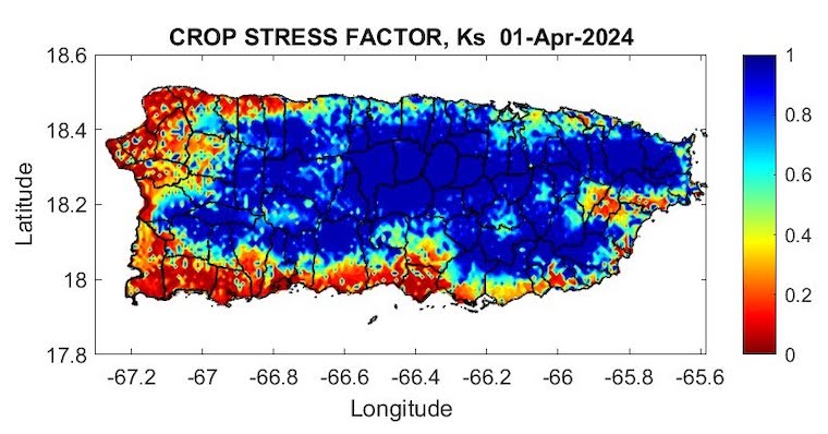
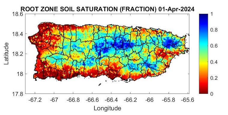
The latest soil moisture data from the Puerto Rico Agricultural Water Management (PRAGWATER) indicates that the driest soils are focused in the northwest quadrant and also the southern plains. Some dryness is also observed along the east and in the vicinity of the San Juan metro area (Figures 3 and 4).
Streamflow and Groundwater Conditions in Puerto Rico
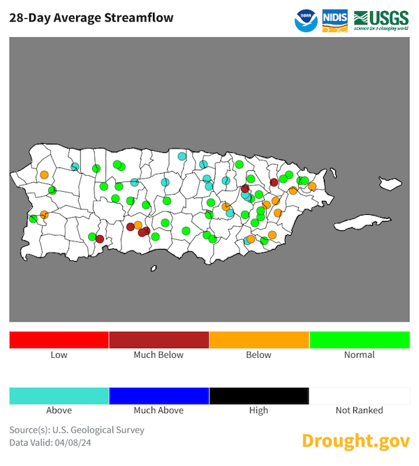
The real-time 28-day average streamflow from the U.S. Geological Survey (USGS) river gauge network (Figure 5) indicates that rivers remain well below normal along the eastern interior, and also in the vicinity of Ponce and Peñuelas. Streams are also drying out in the west. View information on groundwater levels along the South Coast of Puerto Rico.
Outlooks
Seasonal Drought Outlook
The NWS Climate Prediction Center’s Seasonal Drought Outlook (Figures 6 and 7) calls for drought conditions to improve across the region, and drought removal is likely for both the eastern interior and northwestern Puerto Rico. No additional drought is expected to develop elsewhere in Puerto Rico or the U.S. Virgin Islands in the next 3 months.
For More Information
- National Weather Service (NWS) Weather Forecast Office – San Juan: Climate and Drought Information
- NWS Drought Information Statements for Puerto Rico and the U.S. Caribbean
- Drought.gov:
- Caribbean Drought Bulletins. Caribbean Regional Climate Center, Caribbean Institute for Meteorology and Hydrology (CIMH), Barbados
- U.S. Department of Agriculture (USDA) Caribbean Climate Hub drought and disaster assistance resources for tropical forestry and agriculture
Prepared By
Emanuel Rodriguez and Odalys Martinez
National Weather Service San Juan Weather Forecast Office
Héctor J. Jiménez
Office of Climatology, University of Puerto Rico
Meredith Muth
NOAA National Integrated Drought Information System (NIDIS)
Victor Murphy
National Weather Service Southern Region
Christina Chanes
University of the Virgin Islands
Silmarie Crespo Vélez and Nora Álvarez-Berríos
USDA Caribbean Climate Hub, USFS International Institute of Tropical Forestry
Brad Rippey
USDA Office of the Chief Economist
Timothy Dalrymple
USGS Caribbean – Florida Water Science Center (CFWSC)
Puerto Rico Reporting Input: Thanks to the Agricultural Extension Service, College of Agricultural Sciences, University of Puerto Rico-Mayaguez, South West Soil and Water Conservation District, Eastern Soil and Water Conservation District, Center for Landscape Conservation, Caribe Conservation District, and the Association of Cattle Ranchers. Special thanks to agronomists, scientists, ranchers, and farmers: Adrián Vázquez Bandas, Daniel García, Diana Guzmán Colon, Elvin Lebrón, Gabriela Cotto-Santos, Harry Ramírez, Ian Pagán Roig, Isela Ortiz, José B. Ramírez, Joshua Ortiz, Leilany Dávila, Lindolfo Morales, Luis Alexis Rodríguez Cruz, Mariela Butler, Merari Torres Amaro, Nora Álvarez Berrios, Samuel Velez Ramírez, Samuel Rodríguez, Sandra Soto Bayó, Sebastián Díaz.
USVI Reporting Input: : Several individuals contributed to this report and we are acknowledging the following for their support including the farming community across the USVI, UVI faculty, staff, and collaborators of the UVI Department of Chemical and Physical Sciences, UVI Etelman Observatory, UVI Agricultural Experiment Station, VI Department of Agriculture, as well as the USDA Office Chief Economist, National Parks Service in St. Croix and St John, VI Department of Planning and Natural Resources, USDA Farm Service Agency, USDA Natural Resources Conservation Services in St Croix, Coral Bay Community Council and the many volunteer drought reporters, volunteers, and farmers from across the territory.
About This Report
This drought update is issued in partnership between the National Integrated Drought Information System (NIDIS), National Oceanic and Atmospheric Administration (NOAA) National Weather Service, the U.S. Department of Agriculture (USDA), and the University of the Virgin Islands. The purpose of the update is to communicate a potential area of concern for drought expansion and/or development within Puerto Rico and the U.S. Virgin Islands based on recent conditions and the upcoming three-month forecast.
NIDIS and its partners will issue these updates every two months. Subscribe for these U.S. Caribbean drought updates here.


