Extreme drought persists in Texas, Oklahoma, New Mexico, and Kansas.
Drought is likely to continue into spring.
Key Points
- Extreme drought (D3) has developed over parts of Texas, Oklahoma, and southwest Kansas, with exceptional drought (D4) in Oklahoma and New Mexico.
- Above-normal fire risk is in place for drought-stricken regions of the Southern Plains.
- Recent precipitation did little to alleviate drought in the Oklahoma and Texas panhandles and eastern New Mexico.
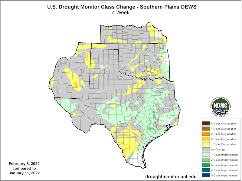
The U.S. Drought Monitor is updated each Thursday to show the location and intensity of drought across the country. Drought categories show experts’ assessments of conditions related to dryness and drought including observations of how much water is available in streams, lakes, and soils compared to usual for the same time of year.
This map shows drought conditions across the Southern Plains Drought Early Warning System as of February 8, 2022.
U.S. Drought Monitor Categories
The U.S. Drought Monitor is updated each Thursday to show the location and intensity of drought across the country. Drought categories show experts’ assessments of conditions related to dryness and drought including observations of how much water is available in streams, lakes, and soils compared to usual for the same time of year.
This map shows drought conditions across the Southern Plains Drought Early Warning System as of February 8, 2022.
Current Drought Conditions and Outlook
U.S. Drought Monitor Conditions
- 81% of the region is in drought (D1 or worse).
- 28% of the region is experiencing extreme (D3) drought.
- Extreme (D3) drought conditions have been in place in this region since August 2019.
- Moderate (D1) or worse drought has been in the region since June 2016.
Drought Development Over the Past Month
Recent Precipitation
- January and February are usually the driest months of the year in the Southern Plains, and precipitation has been lower than normal this winter.
- State-averaged precipitation anomalies for January for the Southern Plains states are as follows:
- Kansas: -0.36 inches
- Oklahoma: -0.6 inches
- Texas: -0.67 inches
- New Mexico: -0.3 inches
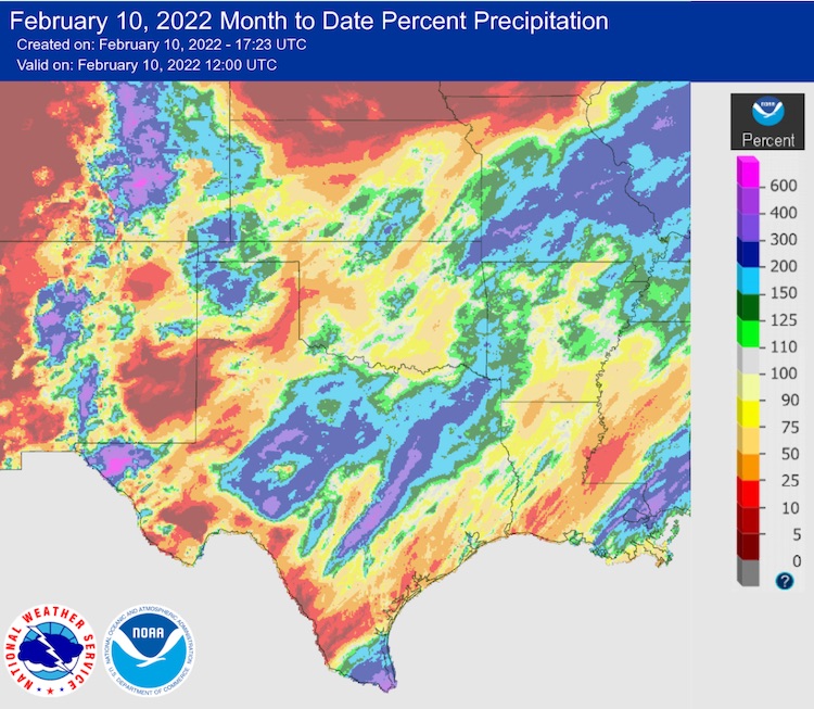
- Storms in early February brought some welcome precipitation to central Texas and eastern Oklahoma, but many areas missed out.
February Month to Date Precipitation
Forecasts and Seasonal Outlooks
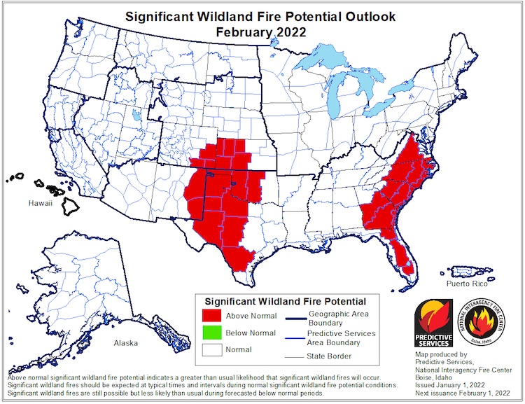
- Fire risk is elevated for drought-stricken areas of the Southern Plains.
- Elevated fire risk is forecast to persist through spring.
Significant Wildland Fire Potential Outlook: February 2022
3-Month Outlook for Winter (February–April 2022)
- Odds favor above-normal temperatures for the southern U.S., including New Mexico and parts of Arizona, Colorado, and Utah.
- Odds favor below-normal precipitation for the southwest U.S., including southern Utah and southern Colorado.
Three-Month Precipitation Outlook: February–April 2022
Three-Month Temperature Outlook: February–April 2022
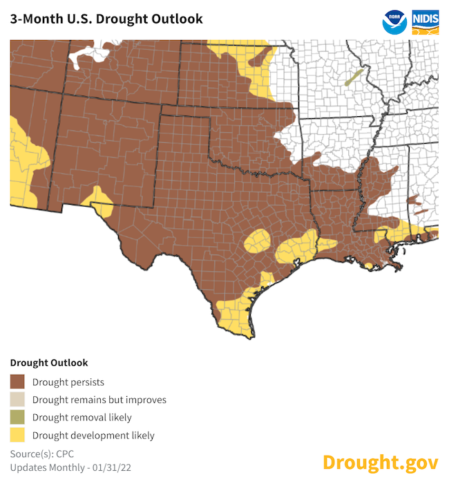
Seasonal Drought Outlook
- Drought is expected to continue for the Southern Plains through spring.
- The Climate Prediction Center's 3-month drought outlook shows drought remaining for all but northeastern Texas, much of Oklahoma, western Kansas, and northern Louisiana.
- Drought development is likely across central Texas, except for those areas receiving heavy rainfall in early February after the outlook was released.
February–April 2022 Drought Outlook
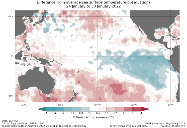
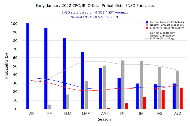
La Niña to Continue into Spring
- One of the primary drivers of drought across the Southwest this season was a La Niña pattern in the Pacific.
- Current forecasts suggest La Niña will continue into the spring, dissipating around April.
- Spring precipitation across the Southern Plains is usually lower than normal in the seasons when La Niña is winding down.
- For more information, please check out the NOAA El Niño–Southern Oscillation (ENSO) blog.
Sea Surface Temperature Anomalies (°C) for January 24–30, 2022
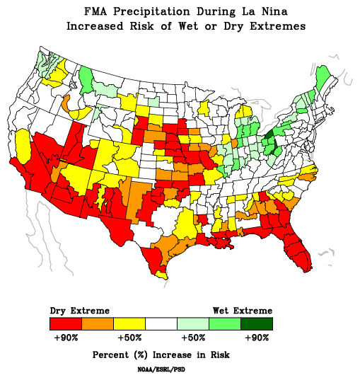
Risk of Wet/Dry Extremes in February–April During La Niña
Probability of El Niño, La Niña, or Neutral Conditions
State-Based Conditions and Impacts
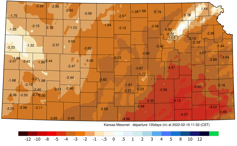
Kansas
- Drought and the December 15 wind event have decimated the wheat crop in the southwest with poor conditions and/or no stands remaining.
- Despite some recent moisture improving conditions in areas of the east/west, record warm temperatures since August with large precipitation deficits continue long-term drought.
- Several large fires have occurred in recent weeks, with fire weather variables at or over the 90th percentile for much of central/east Kansas.
120-Day Departure from Normal Precipitation
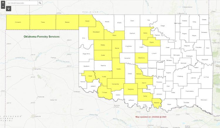
Oklahoma
- Nearly all of the state received beneficial moisture from the winter storm on February 1–3, but the highest totals were confined to far-eastern Oklahoma.
- Long-term deficits have stressed Oklahoma’s winter wheat crop, with many areas seeing a profound lack of wheat pasture for grazing impacting Oklahoma’s livestock producers.
- Wildfires continue to be a concern, with 22 of Oklahoma’s 77 counties under a burn ban.
Oklahoma State and County Burn Ban Status
Texas
- The early February winter storm was beneficial for central and coastal portions of Texas.
- Elsewhere, the winter wheat crop and winter forage are having difficulty, and rainfall is needed in some areas to support spring planting.
- If dry weather persists in west Texas, there will be an elevated threat of spring wildfires.
County Precipitation/Temperature Rankings: August–January
For More Information
NIDIS and its partners will issue future drought updates as conditions evolve.
More local information is available from the following resources:
Prepared By
Joel Lisonbee
NOAA/National Integrated Drought Information System (NIDIS)
Gary McManus
Oklahoma State Climatologist, Oklahoma Mesonet, Oklahoma Climatological Survey
Chip Redmond
Kansas State University
John Nielsen-Gammon
Texas State Climatologist, Texas A&M University
This drought early warning update is issued in partnership between the National Oceanic and Atmospheric Administration (NOAA) and the offices of the state climatologist for Texas, Oklahoma, New Mexico, and Kansas. The purpose of the update is to communicate a potential area of concern for drought expansion and/or development within the Southern Plains based on recent conditions and the upcoming forecast. NIDIS and its partners will issue future drought updates as conditions evolve.
