Climate Engine Launches New Website to Facilitate Drought and Vegetation Monitoring
Climate Engine, with support from NOAA’s National Integrated Drought Information System (NIDIS), is partnering with the Bureau of Land Management (BLM) to guide drought planning on BLM-managed lands
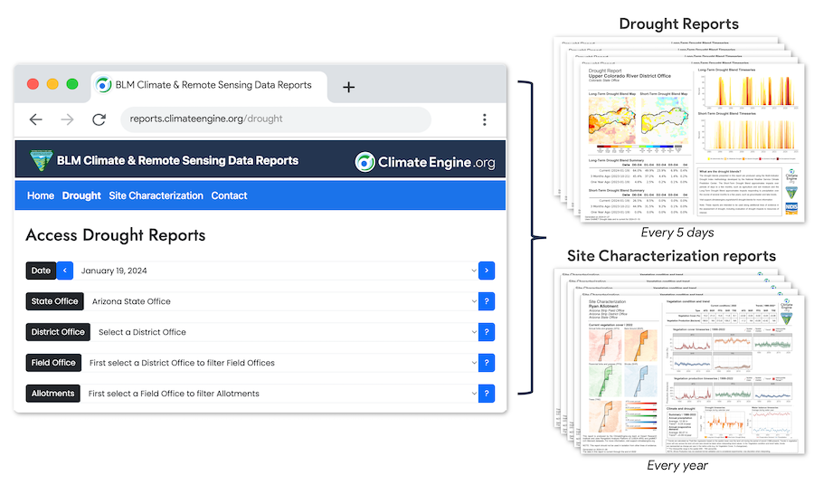
ClimateEngine.org is an innovative tool that provides satellite and climate data in a user-friendly manner to facilitate water conservation, wildfire risk management, agricultural productivity monitoring, and ecological restoration. Created through a partnership between researchers at the Desert Research Institute, the University of California Merced, Google, NOAA’s National Integrated Drought Information System (NIDIS), and other federal partners, Climate Engine allows users to create maps and time series plots for visualizing complex climate data. Now, the team is launching a new publicly accessible platform designed to produce comprehensive and detailed reports for all Bureau of Land Management–managed lands in the contiguous United States.
The reports combine scalable drought summaries and near real-time vegetation conditions to help inform planning and decision-making.
“The goal of this new platform is to lower the barrier to using timely drought and satellite-based vegetation datasets for resource managers,” said Eric Jensen, geospatial data scientist at DRI.
The website provides both drought and site characterization reports that assess drought indicators and satellite-based vegetation cover and productivity over time, with data extending back to 1986 based on the Landsat satellite archive. When combined, this information will build drought resilience on public lands. All of the reports are free to view and download, which builds transparency into the decision-making process.
The Climate Engine team partnered with NIDIS to provide multiple drought indicators at higher spatial resolution than what is available through the U.S. Drought Monitor. Users of the new site will see both long-term (up to 5 years) and short-term (up to 9 months) drought information that combines several drought monitoring indices into a single map for each BLM grazing allotment. This Multi-Indicator Drought Index (or MIDI) combines measures of precipitation and moisture (including the Standardized Precipitation Index and Palmer Drought Severity Index) to approximate drought impacts from changes in precipitation and moisture over short-term and long-term timeframes. Longer-term drought can impact groundwater and reservoir levels, while shorter-term impacts may include drier soils and reduced plant growth. The MIDIs were created using the Climate Engine tool and are the result of NIDIS-funded research.
These tools can allow for more precise and directed drought response and management plans. Satellite-based vegetation data is provided through the Rangeland Analysis Platform, with support by the USDA-ARS. All of the data included in the reports are presented in clear, visually appealing maps and graphs, and drought reports are updated every five days.
“NIDIS has promoted the use of Climate Engine within BLM since 2018, and we believe that this new tool will further empower decision makers to use the best available data for their land planning decisions,” said Steve Ansari, U.S. Drought Portal Manager and physical scientist with NOAA’s National Centers for Environmental Information. “These drought reports provide a nearly real-time snapshot of drought conditions at each land unit and are capable of capturing a lot more detail at a scale that supports BLM decisions.”
“BLM manages around 245 million acres of land, more than any other federal agency. Having these data not only readily available, but in a usable form, will directly contribute to our mission of responsibly managing environmental, cultural, and historical resources across the country,” said Paula Cutillo, National Water Resource Specialist with the BLM. “The sustained and unprecedented drought currently impacting the Western U.S. challenges sustainable resource management, and we are increasingly considering drought severity, water availability, and drought resilience when making land use decisions. We need all of this information to make balanced, forward-looking decisions in a changing climate.”
Future updates and improvements to the platform will include expanded vegetation production reports to further support land use planning and decisions, additional drought indicators, and information about fire history as well as wildfire risk.
Users can refer to detailed guidelines for using the reports, including tutorials and information about the datasets and metrics used, trouble-shooting tips, and answers to frequently asked questions on ClimateEngine.org.
NIDIS has continuously supported Climate Engine since 2015. Learn more about this public-private partnership.