National Weather Service Drought Information Statements Provide Improved Drought Messaging
For nearly two decades, the National Weather Service (NWS) has issued Drought Information Statements to provide up-to-date reports on the current drought situation for regional Weather Forecast Offices' warning and forecast area. These timely statements summarize recent weather and hydrologic conditions, discuss local drought impacts, and provide a local drought outlook.
Last fall, NWS experimentally launched a modernized Drought Information Statement. After incorporating feedback during the testing period, NWS officially transitioned these products into operations this month. The updated Drought Information Statements—which feature additional images, resource links, and more—enhance NWS’s drought messaging by consolidating local information into a user-friendly presentation.
NOAA’s National Integrated Drought Information System (NIDIS) and National Centers for Environmental Information (NCEI) collaborated with NWS to support this important update, including creating customized regional graphics and an interactive map of all Drought Information Statements.
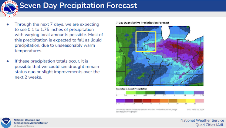
As part of this update, the U.S. Drought Portal (Drought.gov) team created customized regional map images that Weather Forecast Offices can use in the new statements. These maps include key drought and climate indicators—like the U.S. Drought Monitor, recent precipitation conditions and forecasts from NWS, and drought outlooks from the NWS Climate Prediction Center—overlaid with state and Weather Forecast Office regional boundaries. Each high-quality image is automatically updated each day, allowing Weather Forecast Offices to easily incorporate these graphics into their drought messaging.
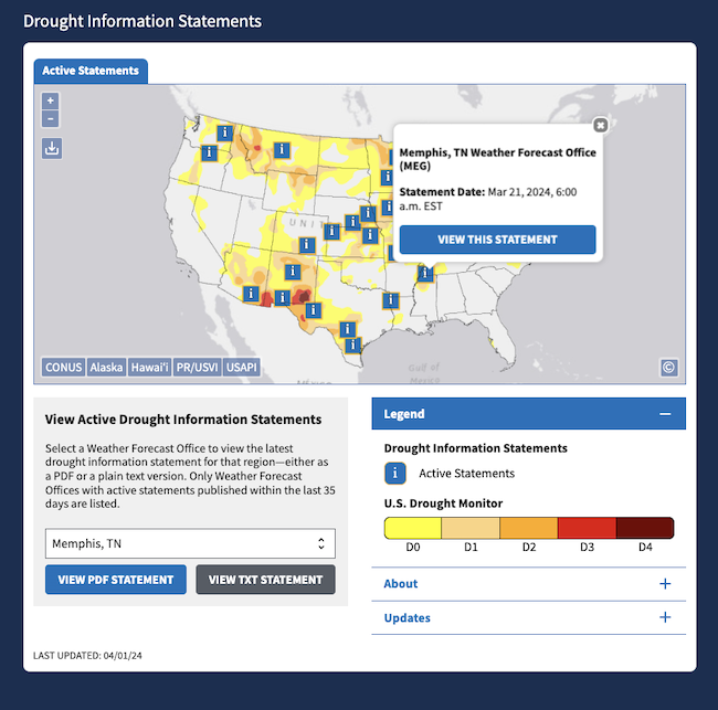
Users can view the modernized statements on their local Weather Forecast Office’s “Drought Information Statement” web page (for example), or view all statements across the country in an interactive map on Drought.gov. The U.S. Drought Portal team created this map to provide a central location for communities across the United States and territories to view local Drought Information Statements. Users can click any “i” icon on the map to view details on an active statement, including the WFO location, date of issuance, and a link to view the full statement on Weather.gov. A dropdown list below the map allows for easy keyboard accessibility, and users can choose to view a PDF or plain text version of each statement. Users can also see all active Drought Information Statements within their state on Drought.gov’s state pages.
The modernization effort began in 2021–2022, when NWS collected suggestions to modernize the Drought Information Statement and make this product a more effective drought messaging tool through the NWS Western States Drought Workshop and extensive field engagement. After an experimental period and an extensive user survey, these new Drought Information Statements are now fully operational. Drawing on NWS and partner-provided drought indicators and tools, NWS Drought Information Statements synthesize local drought conditions, impacts, and outlooks for key partners, such as state climate offices, agricultural and water resources managers, and local media. The new statements also better enable collaboration between neighboring NWS Weather Forecast Offices, providing timely drought messaging with a broader regional context. NIDIS is proud to support this essential climate service from NWS.
To learn more, read the NWS’s Service Change Notice, watch a webinar about the modernization effort, or explore all active statements on Drought.gov.