New Hawaii Rangeland Information Portal (H-RIP) Provides Drought Information Customized to Hawaiian Agricultural Lands
Over the past few decades, drought duration and severity have increased significantly, resulting in over $80 million in agricultural relief across the Hawaiian Islands (Frazier et al., 2022). During drought, ranchers face significant challenges associated with the loss of pasture and forage resources, such as increased costs for supplemental feed, increased cattle mortality, and reduced calving rates.
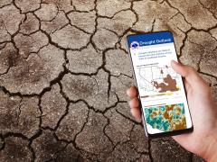
Ranchers face a persistent hurdle to making proactive management decisions due to a lack of timely and accurate drought-related information. The Hawai'i Rangeland Information Portal (H-RIP) was developed to help ranchers fill critical information needs. The H-RIP tool was funded by NOAA’s National Integrated Drought Information System (NIDIS) with support from the Pacific Drought Knowledge Exchange, Hawai'i Cattlemen's Council, the University of Hawai'i, the East-West Center, and the U.S. Department of Agriculture Natural Resources Conservation Service.
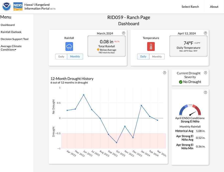
H-RIP is a powerful decision support tool designed for ranchers to get site-specific climate information and a near-term projection of forage growth at their area of interest. H-RIP serves as a hub for four key services:
Real-Time Weather and Drought Updates: H-RIP delivers real-time, site-specific, weather data and drought conditions.
Site-Specific Drought Outlooks: Using predictive insights of El Niño phases, H-RIP provides drought outlooks for the coming 1–3 months tailored to the needs of individual ranches.
Decision Support for Site-Stability: H-RIP includes a decision support tool on forage growth based on the drought outlook for the next 3–6 months.
Historical Drought and Rainfall Patterns: H-RIP also offers a historical view of drought events and rainfall trends, which is critical for long-term strategic planning.
Climate information is derived from high-resolution climate maps obtained from the Hawai'i Climate Data Portal (HCDP). Forage production is estimated using the NRCS 528 Forage Production that uses established relationships between rainfall fall and different grass types to predict forage growth. The H-RIP tool utilizes an almanac perspective of rainfall categorized by the current phase of El Niño to make short-term projections of forage growth.
Learn more about the NIDIS-supported research behind this tool, or watch the H-RIP video tutorial.
References
Frazier, A.G.; Giardina, C.P.; Giambelluca, T.W.; Brewington, L.; Chen, Y.-L.; Chu, P.-S.; Berio Fortini, L.; Hall, D.; Helweg, D.A.; Keener, V.W.; et al. "A Century of Drought in Hawai‘i: Geospatial Analysis and Synthesis across Hydrological, Ecological, and Socioeconomic Scales." Sustainability 2022, 14, 12023. https://doi.org/10.3390/su141912023
Longman, R.J., Frazier, A.G., Giardina, C.P., Parsons, E.W., McDaniel, S. "The Pacific Drought Knowledge Exchange: A Co-Production Approach to Deliver Climate Resources to User Groups." Sustainability 2022, 14, 10554. doi.org/10.3390/su141710554
Text for this article was provided in part by the USDA Southwest Climate Hub.