November snowfall was a bust as warm air and dry temperatures dominated the region.
Key Points
- Extreme drought (D3) conditions continue in parts of the Intermountain West
- The region saw low or no snow totals in November
- Winter precipitation outlooks show:
- Low precipitation totals and above-normal temperatures are likely for the Southwest.
- Western Wyoming and far northern Utah may see above-normal precipitation for the season.
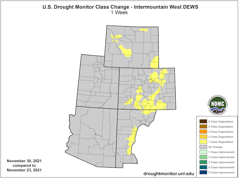
Current U.S. Drought Monitor map for the Intermountain West Drought Early Warning System region with data valid for November 30, 2021. The U.S. Drought Monitor is updated each Thursday to show the location and intensity of drought across the country.
Extreme (D3) to exceptional (D4) drought persists within every state in the Intermountain West Drought Early Warning System.
U.S. Drought Monitor Categories
Current U.S. Drought Monitor map for the Intermountain West Drought Early Warning System region with data valid for November 30, 2021. The U.S. Drought Monitor is updated each Thursday to show the location and intensity of drought across the country.
Extreme (D3) to exceptional (D4) drought persists within every state in the Intermountain West Drought Early Warning System.
Recent and Current Conditions
U.S. Drought Monitor Conditions
- As of November 30, 27% of the Intermountain West is in Extreme to Exceptional (D3–D4) drought.
- There has been marginal improvement to drought conditions over the past four weeks.
- Exceptional (D4) drought remains in Utah.
- Extreme (D3) drought remains in all Intermountain West states.
- Drought conditions have remained or deteriorated in eastern Colorado and southeast Wyoming and New Mexico.
U.S. Drought Monitor 4-Week Change Map
November Conditions: Low Precipitation and High Temperatures
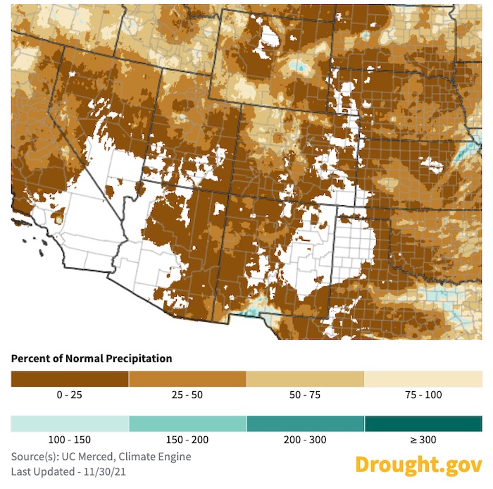
- Southern Arizona, parts of eastern Colorado, and eastern New Mexico had no measurable precipitation during November. The majority of the rest of the region received less than 25% of normal precipitation for this period.
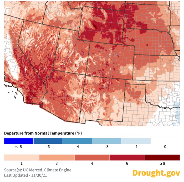
- The whole region experienced above-average temperatures for this time of year. For many locations across the Intermountain West, including most of Wyoming, the average temperature for the month was greater than 4 ºF above normal.
30-Day Percent of Normal Precipitation
30-Day Departure from Normal Temperature
Forecasts and Seasonal Outlooks
Climate Patterns: La Niña Advisory
- NOAA’s El Niño–Southern Oscillation (ENSO) alert system status is currently at La Niña Advisory—meaning La Niña conditions have been observed and are expected to continue through winter.
- La Niña usually correlates with below-normal winter precipitation in the Southwest U.S. For example, since the 1949/1950 winter there have been 24 La Niña winters with 3 having above-average rainfall and 21 with below-average rainfall for Tucson, AZ.
- Seasonal forecasts also show a drying pattern across the Southwest, consistent with a La Niña pattern.
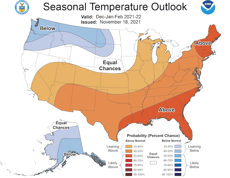
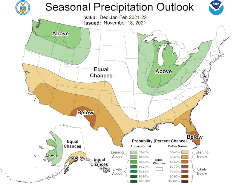
3-Month Outlook for Winter (December 2021–February 2022)
- A warm and dry winter is likely for most of the Intermountain West. Odds are stronger for Arizona and New Mexico.
- Odds slightly favor above-average precipitation for far northern Utah and western Wyoming.
December–February Temperature Outlook
December–February Precipitation Outlook
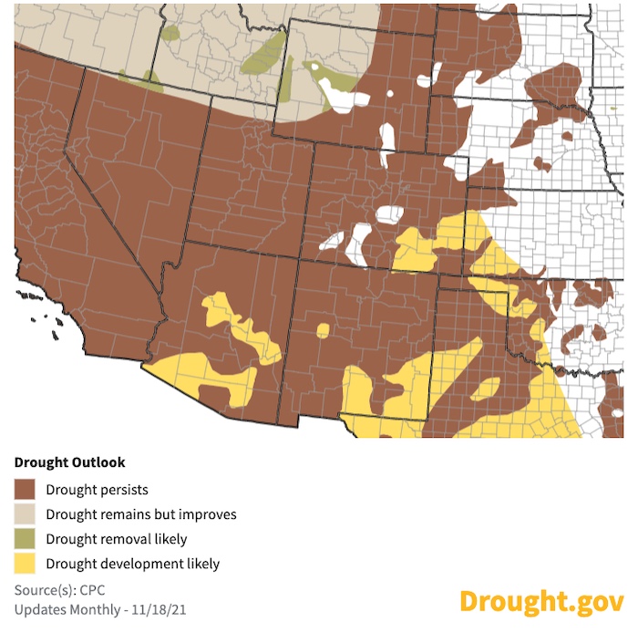
Seasonal Drought Outlook
The Climate Prediction Center's 3-month drought outlook shows drought continuing at least through winter.
U.S. Drought Outlook: November 18, 2021–February 28, 2022
State-Based Conditions and Impacts
Arizona
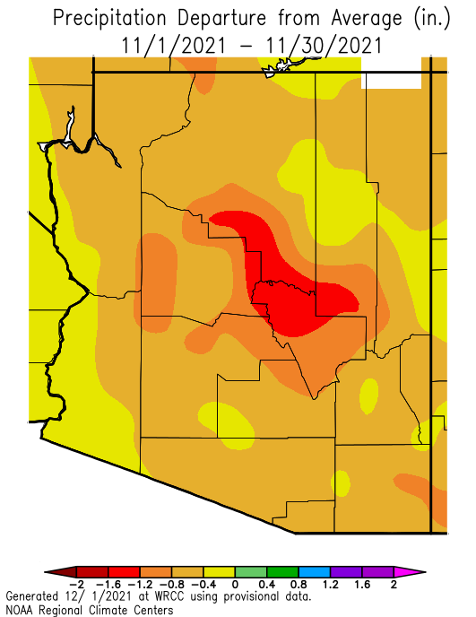
- La Niña produced a very warm and dry November across Arizona. Both Tucson and Phoenix had their second warmest average November temperatures on record; the daily average temperature was above normal every day in Tucson.
- Only one significant rainfall event occurred, leaving November precipitation below to well-below average across the state.
- There were no reported wildfires in November, which allowed prescribed burns to be scheduled in Kaibab National Forest and Tonto National Forest.
Arizona Departure from Average Precipitation: November 2021
Colorado
- Colorado has mostly been dry with little precipitation received across much of the state. Precipitation deficits of 0.25–1.25 inches were noted across the state with little in the way of additional snowpack.
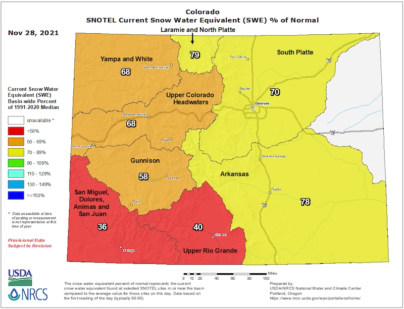
- Snowpack in major river basins across Colorado ranges from 36%–79% of normal. The San Juans and Sangre de Cristos in southern Colorado have seen the driest conditions.
- Monthly temperatures were 2–6 degrees above average statewide with some of the larger monthly departures occurring at higher elevations.
- Snowpack and soil moisture are low across the clear majority of the state, but understanding the impacts of this will come with time. There is still plenty of cold season left for conditions to improve before runoff season in the west, or planting season in the east.
SNOTEL Snow Water Equivalent Percent of Normal
New Mexico
- Drought has worsened over the middle Rio Grande valley.
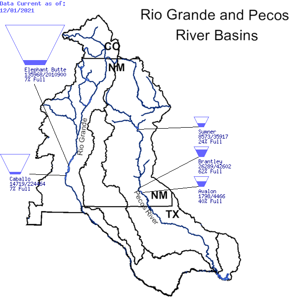
- Reservoir storage in New Mexico still indicates long-term drought conditions persist. Elephant Butte and Caballo reservoirs, on the Rio Grande, are both at 7% full.
Reservoir Storage: Rio Grande and Pecos River Basins
Utah
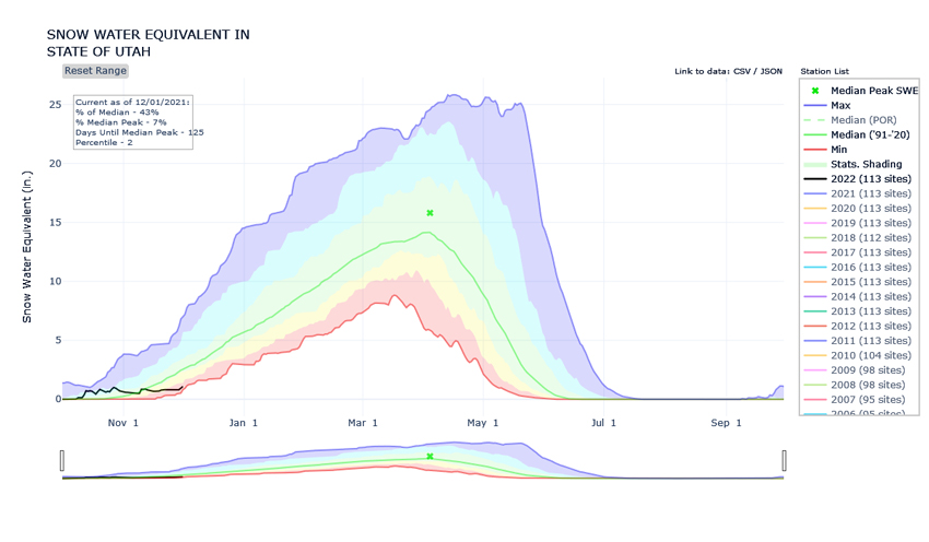
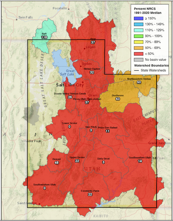
- The warm and dry November has tempered October optimism for a strong start to the snow accumulation season with statewide snowpack flatlining and currently sitting in the 2nd percentile for this time of year. With the exception of far northern Utah, the state’s low-elevations have yet to experience snowfall.
- Soil moisture across the state has trended away from October’s record highs, but remains well-above normal suggesting an efficient spring runoff is in store.
- Statewide reservoir levels remain highly depleted (less than 50% of total storage) and have experienced a significant year-over-year drop (62% this time last year).
Utah Statewide Snow Water Equivalent
Utah Snow Water Equivalent Percent of Median
Wyoming
- After some improvement in soil moisture from October precipitation (snow and rain), conditions started to deteriorate again in November. The ground has remained thawed except for some brief freezes down to about 15 cm during the night, so any precipitation that does fall at least has a chance to still make its way into the soil column.
- Wyoming’s average temperatures for November were above-normal across the state. Temperatures were closest to normal in the Bighorns and a few parts of the northwest, while the rest of the state experienced conditions up to 9 ºF above normal.
- Along with warmer-than-normal temperatures, November was also dry. Only a few isolated pockets of Wyoming saw precipitation totals for the month that were at or above median. These areas were generally in the southern part of the state, while the Wind River Range and the Bighorn and Powder River Basins saw precipitation under the 5th percentile.
- Snowpack is below-normal statewide with the exception of the Wind River Basin, which is currently at 97% of median. The remaining basins are below 70%.
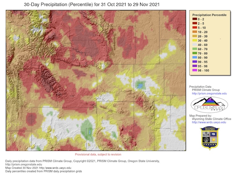
Wyoming 30-Day Percent of Normal Precipitation
For More Information
More local information is available from the following resources:
In Case You Missed It
- November 23, 2021: Southwest Drought Briefing
- December 2, 2021: Drought Monitoring and Reporting in Arizona: Building a Network for Drought Response (Virtual Workshop)
Upcoming Events
- December 7, 2021, 2-3:30 p.m. MST: Southwest Drought Learning Network Quarterly Meeting. Contact joel.lisonbee@noaa.gov for more information.
- December 13, 2021: Southwest Drought Briefing
Prepared By
Joel Lisonbee
NOAA/National Integrated Drought Information System (NIDIS)
Greg Heavener
Warning Coordination Meteorologist, National Weather Service, Pueblo, Colorado
Erin Saffell
Arizona State Climatologist/Arizona State University
Peter Goble
Colorado Climate Center/Colorado State University
Jon Meyer
Utah Climate Center/Utah State University
Tony Bergantino
Water Resources Data System – Wyoming State Climate Office
Erin Boyle
Service Hydrologist, National Weather Service, Tucson, Arizona
This drought status update is issued in partnership between the National Oceanic and Atmospheric Administration (NOAA), and the offices of the state climatologist for Arizona, Colorado, New Mexico, Utah and Wyoming. The purpose of the update is to communicate a potential area of concern for drought expansion and/or development within the Intermountain West based on recent conditions and the upcoming forecast. NIDIS and its partners will issue future drought status updates as conditions evolve.