The territories received excessive rainfall in the last couple of weeks, which brought extensive flooding but improved water levels in reservoirs. No drought is anticipated to develop in the short term.
Key Points
- Regional: The islands received a significant amount of rainfall as the early wet season unfolded. This saturated soils and replenished water reservoirs for most of the region.
- Puerto Rico Impacts: An extremely wet period led to flood, flash flood, and landslide impacts for a large portion of Puerto Rico. Even though the south-southeast coast of Puerto Rico also received rain, it was not enough to replenish groundwater across these regions.
- U.S. Virgin Islands (USVI) Impacts: Farmers in the USVI appreciated recent rains that left the USVI wet. Currently, there is neither dryness nor drought. Regular rainfall improved groundwater levels on St. Thomas and St. Croix in the USVI, while St. John has had intermittent rain with less groundwater improvement. Sporadic rain continues to saturate the soil. In agricultural areas on St. Thomas and St. Croix, impacts of erosion are ongoing, with Bordeaux farmers on St. Thomas reporting some roads impassable due to recent downpours. Wetter conditions spread toward most of the Virgin Islands, erasing any dryness that developed by mid-March.
- Looking Ahead: Near-normal or just-above-normal precipitation is expected through the end of spring, but conditions lean closer to normal during the summer period (June–August). Slightly warmer-than-normal temperatures are expected to prevail across the territories. No drought is expected to develop in the upcoming months.
See below for additional details on current conditions, impacts (including streamflow and soil moisture), and outlooks.
U.S. Drought Monitor map for Puerto Rico and the U.S. Virgin Islands, as of May 6, 2025. The U.S. Drought Monitor is updated each Thursday to show the location and intensity of drought across the country.
The map uses 5 classifications: Abnormally Dry (D0), showing areas that may be going into or are coming out of drought, and four levels of drought (D1–D4).
A drought index combines multiple drought indicators (e.g., precipitation, temperature, soil moisture) to depict drought conditions. For some products, like the U.S. Drought Monitor, authors combine their analysis of drought indicators with input from local observers. Other drought indices, like the Standardized Precipitation Index (SPI), use an objective calculation to describe the severity, location, timing, and/or duration of drought.
Learn MorePeriods of drought can lead to inadequate water supply, threatening the health, safety, and welfare of communities. Streamflow, groundwater, reservoir, and snowpack data are key to monitoring and forecasting water supply.
Learn MoreDrought can reduce the water availability and water quality necessary for productive farms, ranches, and grazing lands, resulting in significant negative direct and indirect economic impacts to the agricultural sector. Monitoring agricultural drought typically focuses on examining levels of precipitation, evaporative demand, soil moisture, and surface/groundwater quantity and quality.
Learn MoreU.S. Drought Monitor
D0 - Abnormally Dry
Abnormally Dry (D0) indicates a region that is going into or coming out of drought, according to the U.S. Drought Monitor. View typical impacts by state.
D1 – Moderate Drought
Moderate Drought (D1) is the first of four drought categories (D1–D4), according to the U.S. Drought Monitor. View typical impacts by state.
D2 – Severe Drought
Severe Drought (D2) is the second of four drought categories (D1–D4), according to the U.S. Drought Monitor. View typical impacts by state.
D3 – Extreme Drought
Extreme Drought (D3) is the third of four drought categories (D1–D4), according to the U.S. Drought Monitor. View typical impacts by state.
D4 – Exceptional Drought
Exceptional Drought (D4) is the most intense drought category, according to the U.S. Drought Monitor. View typical impacts by state.
U.S. Drought Monitor map for Puerto Rico and the U.S. Virgin Islands, as of May 6, 2025. The U.S. Drought Monitor is updated each Thursday to show the location and intensity of drought across the country.
The map uses 5 classifications: Abnormally Dry (D0), showing areas that may be going into or are coming out of drought, and four levels of drought (D1–D4).
The U.S. Drought Monitor is updated weekly on Thursday morning, with data valid through that Tuesday at 7 a.m. ET.
A drought index combines multiple drought indicators (e.g., precipitation, temperature, soil moisture) to depict drought conditions. For some products, like the U.S. Drought Monitor, authors combine their analysis of drought indicators with input from local observers. Other drought indices, like the Standardized Precipitation Index (SPI), use an objective calculation to describe the severity, location, timing, and/or duration of drought.
Learn MorePeriods of drought can lead to inadequate water supply, threatening the health, safety, and welfare of communities. Streamflow, groundwater, reservoir, and snowpack data are key to monitoring and forecasting water supply.
Learn MoreDrought can reduce the water availability and water quality necessary for productive farms, ranches, and grazing lands, resulting in significant negative direct and indirect economic impacts to the agricultural sector. Monitoring agricultural drought typically focuses on examining levels of precipitation, evaporative demand, soil moisture, and surface/groundwater quantity and quality.
Learn MoreThis update is based on data available as of 5 p.m. AST on Tuesday, May 6, 2025. We acknowledge that conditions are evolving.
Current Drought and Climate Conditions
- Puerto Rico and the U.S. Virgin Islands have been drought-free since late April 2024 and late February 2024, respectively.
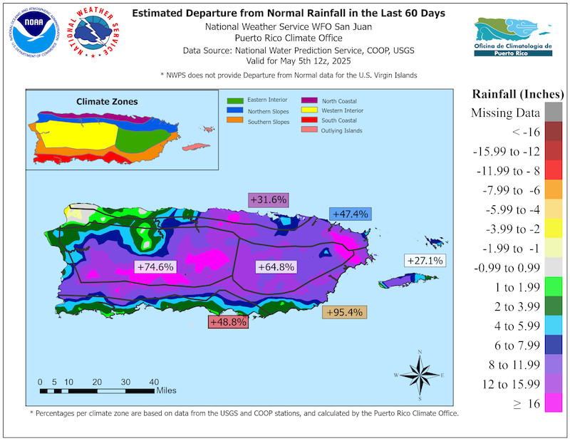
- The onset of the early wet season brought an astonishing amount of rainfall to the territories. In just a 16-day period, areas in the mountains of Puerto Rico collected over 20 inches of rainfall. The rain was so widespread that every location in the islands is currently showing a surplus in precipitation.
- Currently, there is no concern for any of the major water reservoirs, fire ignition, or vegetation stress. However, water levels in wells in south-southeast Puerto Rico have not improved with the recent rains.
- Rainfall amounts are well above normal in the Virgin Islands too, based on data collected from the CoCoRaHS network, which is keeping the soils wet and the vegetation healthy. Charlotte Amalie Airport recorded its fourth wettest April on record with 6.37 inches, which is nearly three times its expected monthly total. The groundwater levels in the U.S. Virgin Islands improved too. To view U.S. Geological Survey (USGS) monitoring well levels, visit the USGS Virgin Islands water conditions page.
Puerto Rico Experienced a Very Wet Spring
Impacts for Puerto Rico and the U.S. Virgin Islands
Agriculture Impacts
- Report your Impacts: To report the effects of dry conditions on your farm projects for future drought updates, use the Drought Condition Monitoring Observations and Reports (CMOR) tool or join the USDA Caribbean Climate Hub reporter group chat on WhatsApp.
- Puerto Rico:
- Central interior region (Caguas, Barranquitas, Naranjito): This region has experienced intense and frequent rainfall. The soil has remained saturated, making planting tasks difficult and favoring the proliferation of pests and weeds, which has increased management costs. In Naranjito, the intensity of the rains also affected supplementary economic activities related to farms, such as agrotourism. While the rains have helped retain soil moisture in well-managed areas, they have exceeded what is typical for this time of year, disrupting regular agricultural practices and indirectly impacting productivity.
- Northern region (Barceloneta, Florida): Recent weeks have been marked by heavy rainfall. In Barceloneta, an extreme precipitation event revived a stream that had been dry for years. Excess moisture has limited vehicle access to some farms and led to fungal problems in some plants. However, one farmer reported an earlier and more productive cacao harvest. Overall, farmers acknowledge that they have received more precipitation around this time than last year, and some are taking advantage of the soil moisture to plant.
- Northeast region (Canovanas, Fajardo): This region shifted from slightly dry conditions a few weeks ago to a week of heavy rains. This has limited access to farms due to muddy terrain and slippery slopes, causing small landslides and erosion in vulnerable areas. Agro-tourism activities, which are a main source of income for some farms, have also been disrupted. Farmers consider these conditions to be different from previous years.
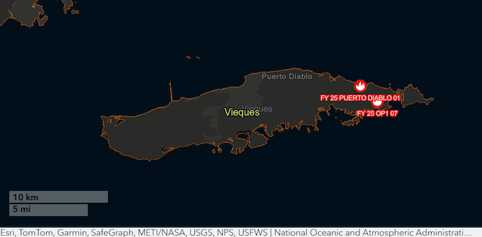
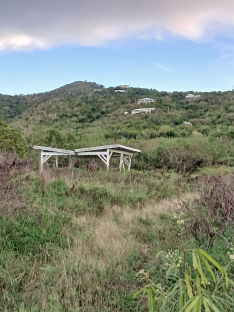
- Eastern Municipal Islands (Culebra and Vieques): Both islands were showing early signs of drought until about two weeks ago, with vegetation drying out and soil hardening due to lack of rain. However, recent rainfall events have eased these conditions, though unevenly. Culebra appears to have received more rain than Vieques in recent days. The rainfall has been enough to halt the most severe signs of drought but has also caused stream overflows and coastal erosion due to runoff. Still, total precipitation has been lower compared to the rest of Puerto Rico. There are two active wildland fires reported in Vieques (figure below).
- Southeast region (Yabucoa): Conditions are unusually wet for the season, preventing typical tasks such as tilling and causing erosion in sandy soils. The excessive soil moisture has delayed operations on farms. The unstable weather, with days of heavy rain alternating with dry days, has complicated agricultural planning.
- Southern region (Coamo, Yauco): Farmers note that there is more precipitation than usual and that the rains arrived earlier than expected. The high amount of rain increases the presence of weeds and pests and makes it difficult to work on farms due to slippery soils. This has led to higher management costs, requiring more labor and inputs to control these issues. For example, a coffee grower in Yauco reported a proliferation of snails in his nurseries due to excess moisture. However, the rainfall has partly benefited coffee bean development. Additionally, some landowners in Coamo report that the rains have been beneficial for crop development, since they don’t have an irrigation system.
- Southwest region (Guánica, Lajas): Significant rainfall over the past two weeks has saturated soils, limiting access to farms and affecting fertilization plans. The rains of May have arrived earlier than expected, disrupting planting schedules for some farms. In previous years, this season was drier, especially in Guánica. But recently, there has been a clear shift toward increased moisture. Despite the humid conditions, no significant increase in pest pressure has been reported.
- Western region (Las Marías, San Sebastián, Lares): April and early May have been unusually wet compared to previous years. Effects observed include the emergence of fungal diseases (e.g., sigatoka), erosion of farm roads, and the reactivation of water streams. While the rain has improved soil moisture, it has prevented tasks such as liming and fertilizing. Some farmers acknowledge that this early rainfall has altered the management dynamics of their farming projects.
- U.S. Virgin Islands:
- St. Thomas: Farmers on St. Thomas report ponds are full and vegetation recovered from earlier dryness. Livestock and poultry farmers have access to feed. Rain caused some landslides and erosion. Farmers report erosion, specifically related to roads, compounded by a multi-year drought that left soil compacted followed by the heavy rain.
- St. John: Row and specialty crop farmers report intermittent heavy rain and high winds. Others added that vegetation is bouncing back, and spring storms were more like those typically experienced late in the year. Most farmers are preparing land and planting specialty crops, microgreens, fruit trees, and quick crops to keep production up. Producers are planning for crop rotation when hotter summer months arrive.
- St. Croix: Many farmers are grateful for rainfall and report ongoing showers. However, heavier rainfall led to soil loss, intermittent flooding, and erosion. Currently, livestock farmers dealing with mud and high winds are also working to plan for feed shortages, which they believe may occur later in the year when less grass is available during the hot, dry months of early summer.
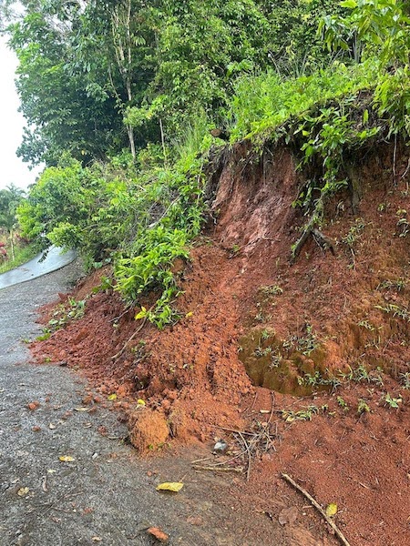
Heavy Rains Are Causing Road Erosion
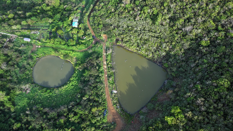
Ponds Are Full on St. Thomas
No Signs of Dryness in the U.S. Virgin Islands

Vegetation Is Healthy and Expanding on St. Croix
Puerto Rico Streamflow and Soil Moisture Impacts
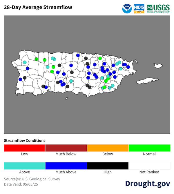
- Most rivers have near-normal to high streamflow across Puerto Rico. Recent rains caused some rivers and creeks to overflow, especially along the interior, northern, and western Puerto Rico.
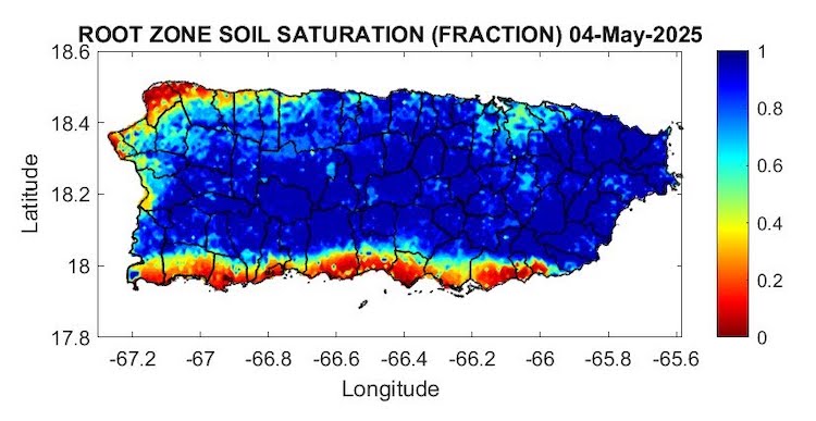
- Soils are also saturated for most portions of the region. However, heavy showers were not as frequent for areas near Aguadilla and Isabela in the northwest. Additionally, the rain in the southernmost coast was not enough to penetrate deep into the soils; hence, it did not replenish groundwater.
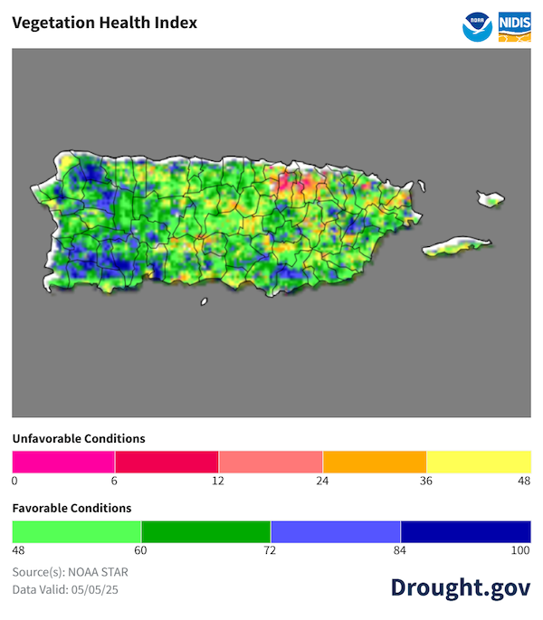
- Vegetation is looking healthy as well. Even the bushes and grass that are common in southern Puerto Rico have become green in comparison with late February.
Most of Puerto Rico's Soils Are Saturated
Puerto Rico River Flow Levels Are Normal to High
Most Vegetation Is Healthy Across Puerto Rico
Outlooks and Potential Impacts for Puerto Rico and the U.S. Virgin Islands
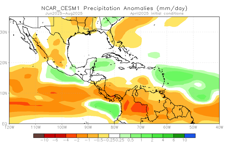
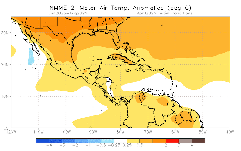
- The North American Multi-Model Ensemble for summer (June–August 2025) indicates near-normal precipitation for Puerto Rico, and slightly wetter than normal for the Virgin Islands. Additionally, there is a 50%-60% chance that temperatures will remain above normal through the summer months.
- No drought is expected to develop over the next three months in Puerto Rico or the U.S. Virgin Islands, according to the NOAA Climate Prediction Center’s current Seasonal Drought Outlook.
Summer Is Expected to Be Warm with Normal Precipitation
Additional Resources
National Weather Service Weather Forecast Offices:
- San Juan Climate and Drought Information
- Puerto Rico and U.S. Virgin Islands Fire Weather Information
- National Weather Service Drought Information Statements
U.S. Drought Portal (Drought.gov):
USDA Caribbean Climate Hub: Drought and disaster assistance resources for tropical forestry and agriculture
Southeast Regional Climate Center: Quarterly Climate Impact and Outlook Reports (March 2025), which includes Puerto Rico and U.S. Virgin Islands.
Prepared By
Emanuel Rodríguez-González
NOAA National Weather Service Weather Forecast Office San Juan
William A. Gould, Nohely Reyes-Pérez, Viviana Medina-Rodríguez
U.S. Department of Agriculture (USDA) Caribbean Climate Hub, USDA Forest Service Research and Development
Christina Chanes
University of the Virgin Islands
Meredith Muth
NOAA National Integrated Drought Information System (NIDIS)
Héctor J. Jiménez
University of Puerto Rico Office of Climatology
Brad Rippey
USDA Office of the Chief Economist
Elliot Sosa
U.S. Geological Survey Caribbean–Florida Water Science Center (CFWSC)
Puerto Rico Reporting Input: Thanks to the Agricultural Extension Service, College of Agricultural Sciences, University of Puerto Rico-Mayagüez, Hacienda Terruño, Hacienda Chocolat, Finca Gonzalez, Finca Caribe, and De Mi Tierra A Mi Pueblo. Special thanks to agronomists, extension agents, ranchers, and farmers: Kevin Ramirez, Josue González, Jonathan González, Samuel Rodriguez, Fernando Bonaparte, Diana Guzmán-Colón, Bernabe Martir, Hilda Bonilla, Karen Bengoa, Luis A. Muñiz Candelaria, Luz Dahlia Jiménez, Jorge A. Reyes Medina, Nick Isett, and others.
USVI Reporting Input: Several individuals contributed to this report and we are acknowledging the following for their support including the farming community across the USVI, UVI faculty, staff, and collaborators of the UVI Department of Chemical and Physical Sciences, UVI Etelman Observatory, UVI Agricultural Experiment Station, VI Department of Agriculture, as well as the USDA Office Chief Economist, National Parks Service in St. Croix and St John, VI Department of Planning and Natural Resources, USDA Farm Service Agency, USDA Natural Resources Conservation Services in St Croix, Coral Bay Community Council and the many volunteer drought reporters, volunteers, and farmers from across the territory.
About This Report
This drought update is issued in partnership between the National Integrated Drought Information System (NIDIS), National Oceanic and Atmospheric Administration (NOAA) National Weather Service, the U.S. Department of Agriculture (USDA), and the University of the Virgin Islands. The purpose of the update is to communicate a potential area of concern for drought expansion and/or development within Puerto Rico and the U.S. Virgin Islands based on recent conditions and the upcoming three-month forecast.
NIDIS and its partners will issue these updates every two months. Subscribe for these U.S. Caribbean drought updates here.
