No Drought in Puerto Rico or St. Croix; Moderate Drought (D1) Continues in St. Thomas & St. John
As the dry season continues, drought is expected to persist and develop in the U.S. Virgin Islands
Key Points
- Regional: Drier than normal conditions persisted in the U.S. Virgin Islands and portions of Puerto Rico. Moderate Drought (D1) is present on Saint Thomas and Saint John in the Virgin Islands, while Abnormally Dry (D0) conditions are observed in Saint Croix.
- Puerto Rico Impacts: In the past two months, rainfall was consistent and not excessive for farm and forest operations across much of Puerto Rico. Somewhat dry conditions in the Caguas area impacted farms without irrigation, while in southwestern Puerto Rico, recent rain was not sufficient to improve persistent dry pasture conditions that the Lajas region experienced throughout 2025. Ranchers in nearby Cabo Roja report sufficient rain and green pastures.
- U.S. Virgin Islands (USVI) Impacts: All three islands are experiencing high winds, which are drying out soil moisture and impacting some specialty and fruit tree farmers. While sporadic rain is still occurring, it was not enough to permeate the soil and improve groundwater levels. Impacts of soil erosion in St. Croix and St. Thomas are ongoing.
- Looking ahead: Models favor near-normal precipitation in February through April across the northeastern Caribbean. Chances are also greater for warmer than normal temperatures. As the dry season continues in the islands, drought is also predicted to persist across St. Thomas and St. John, and develop on St. Croix. No drought is expected to develop across Puerto Rico in the next three months.
- New Resource! Visit the archive of weekly Puerto Rico drought reports developed by the Puerto Rico Scientific Drought Committee (2019 to present).
See below for additional details on current conditions, impacts (including streamflow and soil moisture), and outlooks.
U.S. Drought Monitor map for Puerto Rico and the U.S. Virgin Islands, as of January 27, 2026. The U.S. Drought Monitor is updated each Thursday to show the location and intensity of drought across the country.
The map uses 5 classifications: Abnormally Dry (D0), showing areas that may be going into or are coming out of drought, and four levels of drought (D1–D4).
A drought index combines multiple drought indicators (e.g., precipitation, temperature, soil moisture) to depict drought conditions. For some products, like the U.S. Drought Monitor, authors combine their analysis of drought indicators with input from local observers. Other drought indices, like the Standardized Precipitation Index (SPI), use an objective calculation to describe the severity, location, timing, and/or duration of drought.
Learn MorePeriods of drought can lead to inadequate water supply, threatening the health, safety, and welfare of communities. Streamflow, groundwater, reservoir, and snowpack data are key to monitoring and forecasting water supply.
Learn MoreDrought can reduce the water availability and water quality necessary for productive farms, ranches, and grazing lands, resulting in significant negative direct and indirect economic impacts to the agricultural sector. Monitoring agricultural drought typically focuses on examining levels of precipitation, evaporative demand, soil moisture, and surface/groundwater quantity and quality.
Learn MoreU.S. Drought Monitor
D0 - Abnormally Dry
Abnormally Dry (D0) indicates a region that is going into or coming out of drought, according to the U.S. Drought Monitor. View typical impacts by state.
D1 – Moderate Drought
Moderate Drought (D1) is the first of four drought categories (D1–D4), according to the U.S. Drought Monitor. View typical impacts by state.
D2 – Severe Drought
Severe Drought (D2) is the second of four drought categories (D1–D4), according to the U.S. Drought Monitor. View typical impacts by state.
D3 – Extreme Drought
Extreme Drought (D3) is the third of four drought categories (D1–D4), according to the U.S. Drought Monitor. View typical impacts by state.
D4 – Exceptional Drought
Exceptional Drought (D4) is the most intense drought category, according to the U.S. Drought Monitor. View typical impacts by state.
U.S. Drought Monitor map for Puerto Rico and the U.S. Virgin Islands, as of January 27, 2026. The U.S. Drought Monitor is updated each Thursday to show the location and intensity of drought across the country.
The map uses 5 classifications: Abnormally Dry (D0), showing areas that may be going into or are coming out of drought, and four levels of drought (D1–D4).
The U.S. Drought Monitor is updated weekly on Thursday morning, with data valid through that Tuesday at 7 a.m. EST.
A drought index combines multiple drought indicators (e.g., precipitation, temperature, soil moisture) to depict drought conditions. For some products, like the U.S. Drought Monitor, authors combine their analysis of drought indicators with input from local observers. Other drought indices, like the Standardized Precipitation Index (SPI), use an objective calculation to describe the severity, location, timing, and/or duration of drought.
Learn MorePeriods of drought can lead to inadequate water supply, threatening the health, safety, and welfare of communities. Streamflow, groundwater, reservoir, and snowpack data are key to monitoring and forecasting water supply.
Learn MoreDrought can reduce the water availability and water quality necessary for productive farms, ranches, and grazing lands, resulting in significant negative direct and indirect economic impacts to the agricultural sector. Monitoring agricultural drought typically focuses on examining levels of precipitation, evaporative demand, soil moisture, and surface/groundwater quantity and quality.
Learn MoreThis update is based on data available as of 5:00 p.m. AT on Tuesday, January 27, 2026. We acknowledge that conditions are evolving.
Current Drought and Climate Conditions
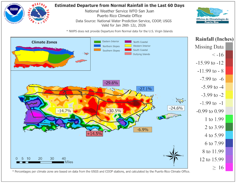
- Drier than normal conditions persisted in the U.S. Virgin Islands and portions of east, southeast and northwest Puerto Rico. According to the U.S. Drought Monitor, Moderate Drought (D1) is present on St. Thomas and St. John. Abnormally Dry (D0) conditions are present in St. Croix. Other areas of Puerto Rico received heavy rainfall at times, preventing dryness and drought from developing.
- Dry conditions decreased overall in Puerto Rico over the last two months. In late November and early December 2025, 49% of Puerto Rico was Abnormally Dry (D0), in regions along the north, interior and southwest of Puerto Rico. As the dry season progressed, rainfall became widespread, reducing the Abnormally Dry (D0) coverage to nearly 15% and preventing drought from developing in mid- to late January.
- In northeast Puerto Rico, some sectors experienced water supply shortages as lakes and small water-intakes were not able to fill. In the southeast, underground wells are not recharging, while soils and vegetation dried out. Similar conditions appear in the northwest, where rainfall has been around 50% of normal in the last 60 days .
- Other areas of Puerto Rico were considerably wetter than normal. Predominantly northeast winds and local climate and topography contributed to concentrated afternoon showers along west and southwest Puerto Rico, with some areas receiving a rainfall surplus of nearly 200% over the last 120 days.
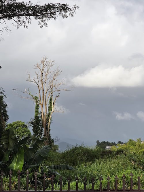
- In the U.S. Virgin Islands, intermittent rains prevented further development of drought. However, high winds contributed to quickly drying soils in some areas.
Puerto Rico’s Fall and Early Winter Were Wet in the West and South-Southwest, But Dry Elsewhere
Impacts for Puerto Rico and the U.S. Virgin Islands
Agricultural Impacts
- Report your Impacts: To report the effects of dry conditions on your farm projects for future Drought Updates, use the Drought Condition Monitoring Observations and Reports (CMOR) tool or join the Caribbean Climate Hub reporting chat on WhatsApp.
- Puerto Rico:
- Central interior region (Aguas Buenas, Caguas, Barranquitas, Orocovis, Naranjito): Farmers report consistent, but not excessive rainfall, allowing fieldwork and promoting growth of fruit trees. Some farmers in a small pocket in the Caguas region experienced dry conditions since November, which stressed bean plants, and affected germination rates and transplant activities.
- Southwest region (Lajas): In Lajas, a rancher reported the previous year was marked by prolonged dry conditions. While substantial rainfall occurred at the end of November, it was insufficient for adequate pasture growth. Since then, there was minimal rainfall, leading to persistent dryness and limited plant growth in pastures. The ranchers anticipate that without a significant increase in precipitation, drought impacts will likely develop by March. Conversely, a rancher in nearby Cabo Rojo reported abundant rainfall and no recent issues related to drought. Pastures in this area remain green, and drought has not impacted his land in recent years.
- No drought impacts were reported in the Northern region (Barceloneta, Ciales, Manatí); Northeast region (Canovanas, Fajardo); East region (Las Piedras); Southern region (Coamo); or Western region (Las Marías, Mayagüez, San Sebastián, Lares).
- U.S. Virgin Islands:
- St. Thomas: Recent rains allowed most vegetation to bounce back and fill ponds. Livestock and poultry farmers have access to feed. Guinea grass is drying quickly due to high and persistent winds. Soil conditions on farms are beginning to show signs of distress. Farmers report rain does not permeate the soil, but rather becomes runoff. Bordeaux farmers repeatedly report some roads are still impassable due to erosion. Groundwater levels are not showing many gains.
- St. John: Row and specialty crop farmers report intermittent rain and ongoing high, sporadic winds that are affecting soil moisture. Most are prepping land, planting specialty crops, microgreens, fruit trees, and quick crops to keep production up. Growers are closely watching bananas for fungus issues. Farmers also report some roads remain impassable due to erosion.
- St. Croix: While recent rains brought some relief, farmers are still dealing with erosion and soil loss. Farmers stated sporadic rain gives a false sense of water access. Livestock farmers are rotating livestock and preparing for the summer, planting row and specialty crops, and establishing drought tolerant vetiver grass to address erosion.
Rains Are Occurring in Eastern Puerto Rico
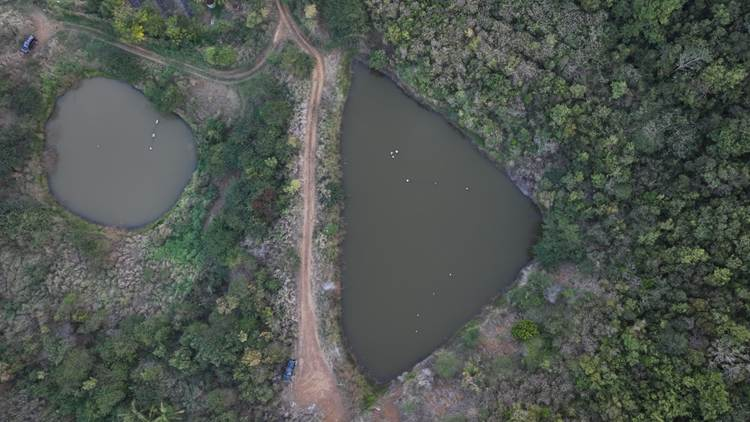
Ponds Are Not Full on St. Thomas
St. John Is Getting Rain and Wind
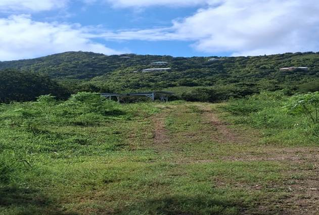
St. Croix Vegetation Is Showing Signs of Dryness
Puerto Rico Streamflow and Soil Moisture Impacts
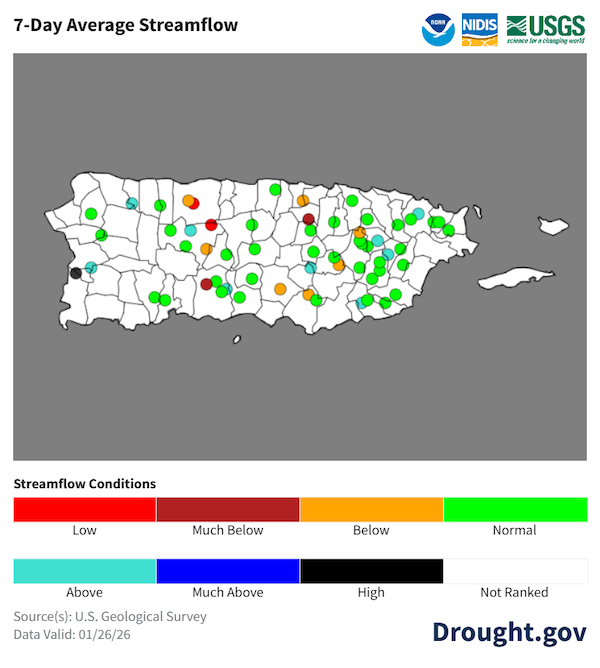
- 7-day average streamflows are below to much below normal in the east and interior, according to the U.S. Geological Survey. Most other streams are near normal, or even above-normal (Rio Rosario and Rio Guajataca) to near record-high (Rio Guanajibo) in the southwest.
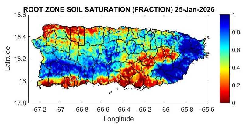
- Dry soils expanded along most of the southern plains, northwest plains, and the eastern interior. Wet soils are observed across the extreme east, east-southeast, and in the west-southwest.
Streamflow Levels Are Mixed Across Puerto Rico
Root Zone Soil Saturation
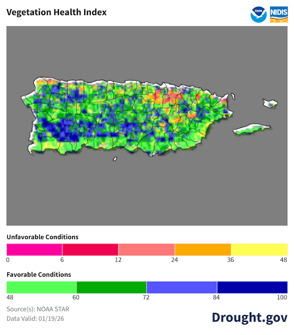
Vegetation Health Index
Outlooks and Potential Impacts for Puerto Rico and the U.S. Virgin Islands
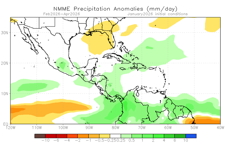
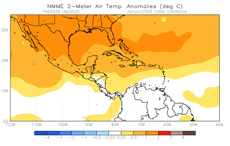
- The North American Multi-Model Ensemble favors near-normal precipitation for Puerto Rico and the Virgin Islands for the period of February to April 2026. There is a 70% chance of experiencing above-normal temperatures.
- As the dry season continues in the northeastern Caribbean islands, drought is forecast to persist across St. Thomas and St. Croix, while it will likely develop onSt. Croix. No drought is expected to develop across Puerto Rico, according to the NOAA Climate Prediction Center’s current Seasonal Drought Outlook.
Normal Precipitation and Above-Normal Temperatures Are Expected for the Islands for the Next Three Months
Additional Resources
National Weather Service Weather Forecast Offices:
- San Juan Climate and Drought Information
- Puerto Rico and U.S. Virgin Islands Fire Weather Information
- National Weather Service Drought Information Statements
U.S. Drought Portal (Drought.gov):
USDA Caribbean Climate Hub:
- Archive of weekly Puerto Rico drought records developed by the Puerto Rico Scientific Drought Committee
- Drought and disaster assistance resources for tropical forestry and agriculture
- Caribbean Drought Learning Network
Southeast Regional Climate Center: Quarterly Climate Impact and Outlook Reports (December 2025), which includes Puerto Rico and U.S. Virgin Islands.
Prepared By
Emanuel Rodríguez-González
NOAA National Weather Service Weather Forecast Office San Juan
William A. Gould & Nora L. Alvarez Berrios
U.S. Department of Agriculture (USDA) Caribbean Climate Hub, USDA Forest Service Research and Development
Christina Chanes
University of the Virgin Islands
Meredith Muth
NOAA National Integrated Drought Information System (NIDIS)
Héctor J. Jiménez
University of Puerto Rico Office of Climatology
Elliot Sosa
U.S. Geological Survey Caribbean–Florida Water Science Center (CFWSC)
Brad Rippey
USDA Office of the Chief Economist
Puerto Rico Reporting Input: Thanks to Café Xiojana, Hacienda Terruño, Hacienda Chocolat, Finca Gonzalez, and De Mi Tierra A Mi Pueblo. Special thanks to agronomists, extension agents, researchers, volunteers, ranchers, and farmers: Adalberto Franqui, Jorge L. Alicea, Silmarie Crespo-Velez, Harry Ramirez, and others.
USVI Reporting Input: Several individuals contributed to this report, and we acknowledge the following for their support: the farming community across the USVI, UVI faculty, staff, and collaborators of the UVI Department of Chemical and Physical Sciences, UVI Etelman Observatory, UVI Agricultural Experiment Station, VI Department of Agriculture, as well as the USDA Office Chief Economist, National Parks Service in St. Croix and St John, VI Department of Planning and Natural Resources, USDA Farm Service Agency, USDA Natural Resources Conservation Services in St Croix, Coral Bay Community Council, and the many volunteer drought reporters, volunteers, and farmers from across the territory.
About This Report
This drought update is issued in partnership between the National Integrated Drought Information System (NIDIS), National Oceanic and Atmospheric Administration (NOAA) National Weather Service, the U.S. Department of Agriculture (USDA), and the University of the Virgin Islands. The purpose of the update is to communicate a potential area of concern for drought expansion and/or development within Puerto Rico and the U.S. Virgin Islands based on recent conditions and the upcoming three-month forecast. NIDIS is an interagency program within the Climate Program Office, which is part of NOAA's Office of Oceanic and Atmospheric Research.
NIDIS and its partners will issue these updates every two months. Subscribe for these U.S. Caribbean drought updates here.


