Agenda of webinar, definition of NIDIS, definition of Drought Early Warning System, details about launch of Pacific Northwest Drought Early Warning System.

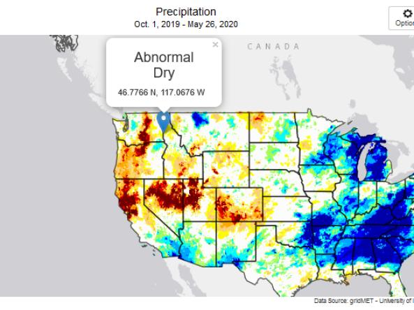
While much of the Pacific Northwest is experiencing abnormally dry or drought conditions, the region as a whole is faring better than it was a year ago during the record-breaking drought of 2015. The abnormally warm start to the calendar year led to a much earlier and faster melt of the region’s snowpack. As the summer of 2016 progresses this early runoff could result in below-average streamflows and higher water temperatures.

As last year’s El Niño continues to deteriorate, CPC has issued a La Niña watch as conditions favorable to the development of an (albeit weak) La Niña are expected to continue during August-October. CPC is predicting a 55-60% chance of La Niña occurring during the fall and winter of 2016-17.
Previous La Nina’s have brought cooler and wetter conditions to the Pacific Northwest during winter months.

Slides with maps show:
Despite some relief in early July when substantial precipitation fell in some basins, precipitation overall has been well below average through July along the Rocky Mountain Front and Upper Yellowstone for the second year in a row. Above-average temperatures coupled with diminished snowpack also led to early runoff. Low soil moisture levels depicted by NASA GRACE models illustrate the lack of June precipitation which impacted shallow groundwater and root zone moisture particularly along the Rocky Mountain Front and Upper and Lower Yellowstone.

The National Integrated Drought Information System, in partnership with NOAA’s Western Regional Climate Center (WRCC), the California Nevada Applications Program (CNAP, a NOAA Regional Integrated Science Applications team), the Desert Research Institute (DRI), and the National Drought Mitigation Center (NDMC), hosted the “Integrating Drought Science and Information into Wildfire Management Workshop” in Boise, Idaho on 21-22 October 2015. Seventeen federal, state, NGO, and academic entities attended the workshop.

Agenda, speakers and goals for PNW DEWS Kickoff.

Describes the planning process leading up to the launch of the Pacific Northwest DEWS.