
Mid-Atlantic
The climate of the Mid-Atlantic is characterized by cold winters and warm, humid summers, though conditions vary considerably with the diverse topography of the region. Drought has occurred frequently in the Mid-Atlantic states over the past century. Major droughts occurred in the 1930s, 1940s, 1960s, 1980s, with more recent droughts occurring between 1998 and 2002, in 2016, and in 2024-2025. Across the Mid-Atlantic, annual precipitation is projected to increase over the next century. However, naturally occurring seasonal droughts will also continue to be a part of the climate, even if precipitation increases. Such droughts are projected to be more intense because of higher temperatures, changing precipitation patterns, and loss of soil moisture. In 2024, heat and a lack of rainfall led to widespread drought across the Mid-Atlantic region. For some locations, the 2024-2025 drought was the worst the region had experienced in more than two decades. Significant impacts were felt across both natural and managed landscapes, as well as multiple sectors, including agriculture, mining, public health, and water utilities. In response to these conditions and impacts, in 2026, NIDIS launched the Mid-Atlantic DEWS, a collaborative federal, tribal, state, and local interagency effort to improve early warning capacity and resilience to drought in the region.
Primary contact: Rocky Bilotta, Regional Drought Information Coordinator
NIDIS and the Northeast Regional Climate Center hosted a series of virtual meetings in March-April 2025 with approximately 140 participants from state agencies, local government, water utilities, academia, and non-profits in the Mid-Atlantic region. The purpose of these follow-up meetings was to: (1) assess the 2024-2025 drought; (2) understand how the drought impacted communities and the additional information and resources that would have strengthened drought resilience through the drought period; and (3) identify lessons learned and how to integrate drought early warning capacity into a Mid-Atlantic Drought Early Warning System.
The 2024-2025 Mid-Atlantic Drought Assessment discusses the origins of the drought, its evolution and impacts between June 2024 and May 2025, and a review of response activities. It also presents stakeholder-identified opportunities for further collaboration, research, and capacity building for greater drought resilience in the Mid-Atlantic region.
Regional Activities
NIDIS and the Northeast Regional Climate Center hosted a …
2025
2025
On September 27, 2024, NOAA’s National Integrated Drought Information System (NIDIS), the Northeast Regional Climate Center (NRCC), and NOAA’s National Centers for Environmental Information…
2024
Observation + Monitoring
When monitoring drought, it is important to look at data across the spectrum—from the atmosphere, land surface, and water availability below the surface. The list of data and maps below has been customized for the Mid-Atlantic, and provides a snapshot of conditions across that spectrum, including precipitation and temperature departure data, evaporative demand, streamflow, soil moisture, groundwater, and various derived indices for monitoring drought in the region. Monitoring for the impact of drought is also important, and resources to submit conditions and/or impacts and view conditions are provided.
Regional Data and Maps
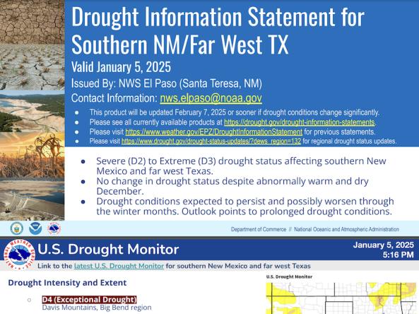
National Weather Service drought information statements provide up-to-date reports on the current drought situation for a Weather Forecast Office’s county warning and forecast area.
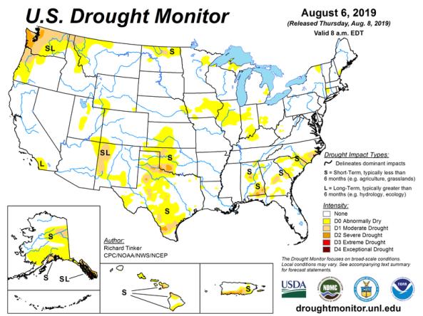
The U.S. Drought Monitor is a map updated each Thursday to show the location and intensity of drought across the country.
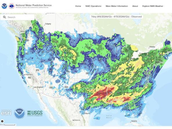
The National Weather Service's National Water Prediction Service (NWPS) provides short-term observed and climatic trends of precipitation across the lower 48 United States (CONUS), Puerto Ric
The National Water Dashboard is an interactive map viewer that shows provisional real-time water data from more than 13,000 USGS observation stations in context with weather-related data
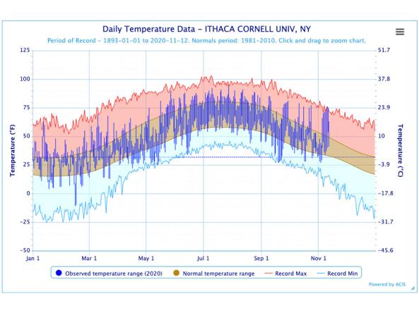
The Regional Climate Centers (RCC) Applied Climate Information System (ACIS) offers interactive temperature and precipitation charts with single- or multi-station capabilities.
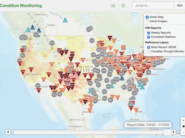
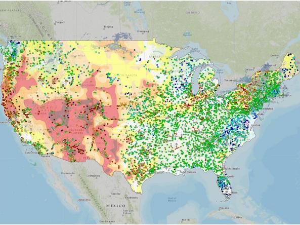
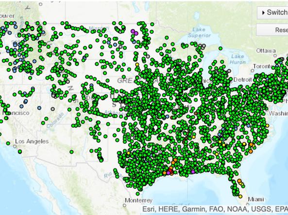
This condition monitoring map is a tool intended to depict local, community-level conditions and how recent weather and climate events have affected those communities.
Planning + Preparedness
There is little that can be done to influence the weather patterns that cause drought, but preparatory actions and policies can help communities cope with drought impacts. Drought planning can ensure continuity of public services and quality of life. Drought planning can be done at the local and/or state level, or integrated into existing plans (e.g., hazard mitigation planning, land-use planning).
Regional Drought Planning Resources

Prediction + Forecasting
When will drought affect me? How long could it last? This section includes resources for drought prediction and forecasting on what could be ahead, including short-term (e.g., 8–14 day) and subseasonal (e.g., monthly) to seasonal forecasts. The appropriate time scale will depend upon how this information is being used (e.g., drought response, mitigation management action, long-term planning). Weather and climate prediction is an evolving science, as researchers continue to find ways to improve models and forecasting capabilities at various time scales.
Regional Forecasts and Outlooks
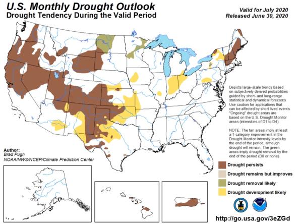
The monthly and seasonal (3-month) outlook for drought tendency from the Climate Prediction Center (CPC), which depicts large-scale trends based on subjectively derived probabilities guided by shor
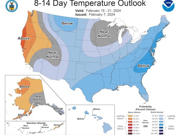
The Climate Prediction Center (CPC) produces temperature and precipitation outlooks for the U.S., including 6-10 day, 8-14 day, monthly, and seasonal outlooks.
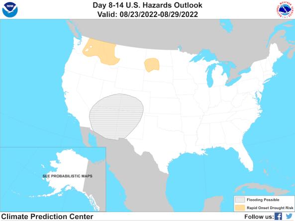
The Climate Prediction Center's Day 8–14 (Week 2) U.S. Hazards Outlook shows potential hazardous conditions related to temperature, precipitation, wind, snow, and rapid onset drought.
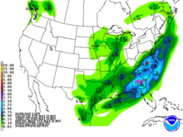
NWS WPC produces Quantitative Precipitation Forecasts (QPFs) that depict the amount of liquid precipitation expected to fall in a defined period of time.
The National Weather Service's National Water Prediction Service (NWPS) provides river stage observations and forecasts and long-range river flood outlooks across the lower 48 Unite
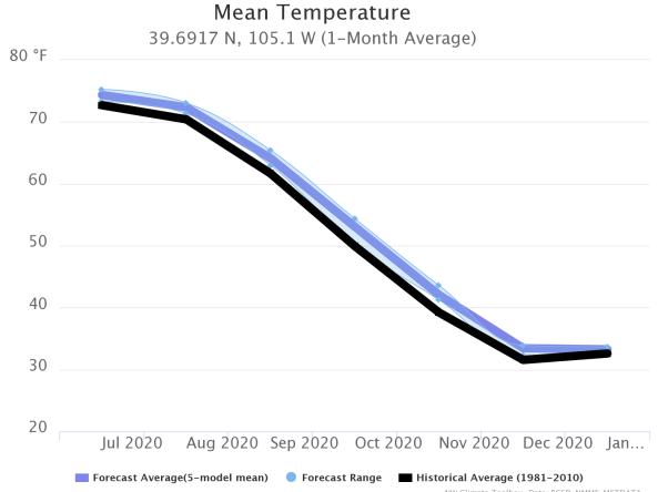
This tool, available as part of The Climate Toolbox, provides a graphical summary of seasonal climate forecasts of temperature and precipitation for the next sever months for a selected location.
Communication + Outreach
An important component for drought early warning is communicating this information to stakeholders across the Mid-Atlantic region that need this information in order to make more informed decisions. There are various ways drought information is communicated across the Mid-Atlantic, including a Mid-Atlantic DEWS email list and NOAA’s quarterly climate report.
Regional Communications Documents

Research + Applications
Research to better understand drought in the Mid-Atlantic and its development, persistence, improvement, and interaction with other hazards is critical to providing timely and reliable information, products, and services in support of drought early warning. This page highlights research projects that are studying drought in the Mid-Atlantic region, with support from NIDIS.