Understanding Upper Missouri River Basin Soil Moisture and Snowpack
A cross-agency partnership to support data for drought and flood response across the Upper Missouri River Basin
Improving Soil Moisture and Plains Snowpack Monitoring in the Upper Missouri River Basin
Between 2011-2019, the Upper Missouri River Basin (Montana, Nebraska, North Dakota, South Dakota, and Wyoming) experienced multiple extreme drought and flood events, leading to loss of infrastructure, agricultural production, and private property. Historic flooding in 2011, a historic flash drought in 2017, and flooding in 2019 led to billions of dollars of losses and damages. After-action reports pointed to the need for more and better observational data to support improved forecast operations, particularly soil moisture and lowlands (plains) snow measurements.
Under Congressional direction from the Infrastructure, Investment, and Jobs Act, the U.S. Army Corps of Engineers and NOAA’s National Weather Service and National Integrated Drought Information System (NIDIS) partnered to advance observational information about water extremes in the region.
Upper Missouri River Basin Soil Moisture and Snowpack Project
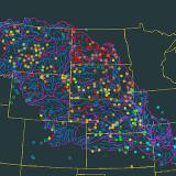
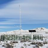
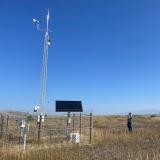
This multi-agency effort involved building out 540 new mesonet stations in the Upper Missouri River Basin, establishing a pilot program for data acquisition and use, and assessing the value of the new data to improve drought and flood monitoring in the basin.
Over the past three years, NIDIS has led the assessment component of this project—the “Upper Missouri River Basin Data Value Study.” The Data Value Study aims to explore needs and applications for data from the Upper Missouri River Basin Soil Moisture and Plains Snow Monitoring Build-Out to support improvements to water resource models, drought monitoring capabilities, and other applications.
This project additionally contributes to the NIDIS-sponsored National Coordinated Soil Moisture Monitoring Network (NCSMMN), and findings from the Data Value Study will be disseminated to the NCSMMN community, advancing soil moisture science and impact nationwide.
Network Build-Out | Data Acquisition and Use Pilot | Data Value Study |
|---|---|---|
| Led by the U.S. Army Corps of Engineers | Led by NOAA's National Weather Service National Mesonet Program | Led by NOAA's National Integrated Drought Information System |
Lead the build-out of a network of 540 soil moisture and plains snowpack monitoring stations (including modification of existing stations) by state mesonets in the Upper Missouri River Basin. This network will provide high-quality “total water” monitoring data across the basin. Watch a short video overview of this project. | Establish a pilot program for the acquisition and use of data generated by the expanded network. Develop an improved data server platform to manage the broader range of Upper Missouri River Basin data, provide data quality checks, and support user-friendly public access. | Initiate a study of the pilot program to evaluate how the data generated by the network can support improvements to water resource models, drought monitoring capabilities, and other applications. |
For more information, please contact Elise Osenga (elise.osenga@noaa.gov).

The Data Value Study: Evaluating Applications of Expanded Soil Moisture and Plains Snow Data
About the Data Value Study
Led by NOAA's National Integrated Drought Information System (NIDIS), the Data Value Study is a 4-year, $1 million effort that studies how soil moisture and plains snowpack data generated by an expanded Upper Missouri River Basin mesonet network will support improved monitoring of drought and flood conditions in the Basin, as well as other climate and weather applications. This includes understanding how the data will improve weather and climate forecasting products, remote-sensing products, and models.
In addition to the focus on data use, the project team also assessed the viability of the ownership and operational structure of the Upper Missouri River Basin Soil Moisture and Snowpack project, including network data acquisition by NOAA’s National Mesonet Program.
The Data Value Study’s interagency team includes NOAA; U.S. Army Corps of Engineers; U.S. Department of Agriculture’s Natural Resources Conservation Service; U.S. Geological Survey; U.S. Bureau of Reclamation; National Aeronautics and Space Administration; tribal nations and state mesonets in Montana, Nebraska, North Dakota, South Dakota, and Wyoming; universities; and private companies. NIDIS is an interagency program within the Climate Program Office, which is part of NOAA's Office of Oceanic and Atmospheric Research.

Data Value Study Key Findings
- Expanded in situ networks have the capacity to improve drought early warning and tracking using soil moisture.
- Using machine learning techniques, expanded in situ data can be used to improve soil moisture model accuracy and to calibrate and validate satellite soil moisture products.
- Upper Missouri River Basin soil moisture and soil temperature demonstrate potential to improve federal runoff and streamflow forecasts.
- New stations with a short period of record can be made useful for drought and flood monitoring by putting soil conditions in context with trends, soil type, and vegetation stress.
- Across multiple sectors, there is high interest in using soil moisture information, but more resources are needed to support interpretation and application.
- The National Coordinated Soil Moisture Monitoring Network is leveraging findings from the UMRB Data Value Study to advance and support soil moisture applications at a national scale.
Explore Data Value Study Projects
In order to carry out the Upper Missouri River Basin Data Value Study, NIDIS contracted with experts from private industry, universities, and state and federal agencies to conduct ten projects. Each project provided a different lens for exploring one of the key topic areas listed above.
Explore detailed findings from each of these ten projects below:
Using Soil Moisture Data in a Hydrologic Forecasting System
This project explored the potential of Upper Missouri River Basin (UMRB) mesonet data to enhance hydrologic models used in streamflow and runoff forecasts for hydrologic operations. The project was led by the National Weather Service’s Missouri Basin River Forecast Center (MBRFC).
- This study found that new UMRB mesonet stations improved spatial coverage of precipitation data, with the potential to increase the accuracy of U.S. Army Corps of Engineers and U.S. Bureau of Reclamation runoff forecasts.
- Soil temperature data from the UMRB stations provide new context to qualitatively understand runoff conditions by providing a way to estimate frost thickness.
- As more stations and longer periods of record become available in the UMRB, in situ soil moisture readings could be used to adjust model parameters to improve forecasts of high streamflow events and flooding.
Applications of UMRB Plains Snow Data to the Snow Data Assimilation System
This project explored how new snowpack monitoring data from previously unmonitored locations can improve snow modeling in the Upper Missouri River Basin (UMRB). The project was led by RTI International and the Cooperative Institute for Research to Operations in Hydrology (CIROH).
- The findings from this project suggest that the new UMRB stations will provide more accurate information about snowpack for locations with distinct micro-climates. Denser spatial coverage can better support local decision-making around hazards and hydrologic planning.
- The insights gained will help inform improvements in snow data assimilation in this region for the SNODAS (SNOw Data Assimilation System) model. Data from the new UMRB stations have already been integrated into SNODAS operations.
- Future work should optimize data assimilation techniques, expand monitoring capabilities, and verify the accuracy of new station data.
Improving Runoff and Streamflow Model Performance Using UMRB Data
This project explored the potential usefulness of in situ soil moisture data for setting parameters for and training a model (HEC-HMS) that the U.S. Army Corps of Engineers uses to forecast streamflow and runoff. This project was led by the U.S. Army Corps of Engineers.
- To operate reservoirs within the UMRB, the U.S. Army Corps of Engineers relies on hydrological modeling software—Hydrologic Engineering Center-Hydrologic Modeling System (HEC-HMS)—to generate runoff and streamflow forecasts from rainfall events.
- This analysis provides evidence that in situ soil moisture data and HEC-HMS modeled soil moisture show sufficient correlation to use for calibration and adjustment of modeled soil parameters in the UMRB.
- Using soil moisture to set model parameters (initialize) and train HEC-HMS rainfall runoff forecasts reduced the time necessary to calibrate the model, allowing for a more rapid production of these forecasts.
A Dashboard for Communicating UMRB Soil Moisture and Snowpack
The Upper Missouri River Basin (UMRB) Soil Moisture and Snow Maps Dashboard offers map products that enable the drought monitoring community to use data from new UMRB stations within the first year of station establishment. This project was led by NOAA’s National Centers for Environmental Information, the Cooperative Institute for Satellite Earth System Studies, and South Dakota State University.
- The research team created an experimental UMRB Soil Moisture and Snow Maps Dashboard on Drought.gov that features interactive maps using UMRB mesonet station data. Maps are available for three soil depths and are updated weekly on Tuesdays:
- Fractional Available Water (FAW)
- Categorized Soil Moisture
- Soil Moisture Change Maps
- Current Snow Depth Conditions
- Frozen Soil Conditions (Soil Frost and Thaw Depth)
- The products created for this dashboard put soil conditions in context with trends, soil type, and vegetation stress.
- These new approaches to communicating soil moisture and snowpack conditions benefit the UMRB region by making data from new stations actionable and could provide a template for networks in other regions also seeking to convey soil moisture information from a limited data record.
Literature Review: The Value of Long-Term In Situ Soil Moisture and Snowpack Monitoring

This project described the state of published research on economic and scientific benefits of long-term monitoring of soil moisture and plains snowpack. It was led by researchers from Texas A&M University.
This research resulted in a literature review published in Vadose Zone Journal. Key findings include:
- In situ soil moisture and plains snowpack monitoring were relatively sparse throughout the UMRB prior to the U.S. Army Corps of Engineers UMRB network build-out. These variables are less well monitored globally than mid- to high-elevation snowpack and meteorological variables (e.g., precipitation).
- There are very few studies on the applications of soil moisture or snowpack data within the UMRB region.
- Where soil moisture and plains snowpack data are available globally, people use them for a variety of purposes, including water resource management, natural disaster prediction, ecological monitoring, and calibration and validation of satellite data and land surface models.
- Expanding in situ soil moisture and plains snowpack monitoring can benefit multiple sectors.
- Long-term soil moisture and snowpack monitoring can reduce environmental, economic, and social impacts of natural hazards and disasters.
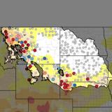
UMRB Sensitivity Analysis: A Test Case for Economic Benefits of Expanded Soil Moisture Monitoring
This project tested how increasing station density in the Upper Missouri River Basin (UMRB) might impact hypothetical drought monitoring, flood prediction, and drought payment scenarios. This project was led by the Ohio State University.
The researchers used a hypothetical case study to test the accuracy of the UMRB soil moisture network’s representation of basin-wide soil moisture conditions using the 2017 Water Year, which saw severe drought in the region. In this analysis:
- Skill in classifying drought conditions based on soil moisture improved with network expansion, by 18.2%, 19.4%, and 38% at 5 cm, 20 cm, and 50 cm depths, respectively.
- Skill in classifying wetter-than-normal conditions improved with network expansion, by 50%, 95.7%, and 156.3% at 5 cm, 20 cm, and 50 cm depths, respectively.
- Expanding soil moisture monitoring has the potential to improve the accuracy of drought payouts for products that use in situ soil moisture information to identify drought severity and extent.
Improving NASA SMAP Soil Moisture Using UMRB Data

This project explored how data from higher-density monitoring stations in the Upper Missouri River Basin (UMRB) could enhance soil moisture products, with applications for enhancing land surface models used in drought and flood monitoring. It was led by NASA’s Goddard Space Flight Center.
- This project found assimilating in situ UMRB soil moisture data to correct SMAP satellite soil moisture estimates improved the accuracy of these products, which are commonly used in land surface models for tracking drought or forecasting floods.
- Land surface model products that used the in situ-adjusted SMAP soil moisture inputs performed better at representing real-world conditions than model products that used un-adjusted SMAP soil moisture estimates as an input.
- Because of its station density, scientists can use the recently expanded UMRB mesonet network for satellite calibration and validation research.
Using Machine Learning to Improve Model Representation of Soil Moisture in the UMRB
This project tested if increased in situ soil moisture monitoring could improve model accuracy through a new approach: using knowledge-guided machine learning trained on national-scale soil moisture models and refined with in situ soil moisture data. It was led by the Montana Climate Office.
- The research team trained a deep learning model on decades of NASA SPoRT-LIS simulations to capture broad relationships between weather and soil. They then fine tuned the model using ground-based station data to correct local biases and better reflect real conditions. Model outputs were then compared to soil moisture data from stations omitted from model training.
- The knowledge-guided machine learning model more than doubled the accuracy of shallow soil moisture measurements nationally, compared to the unadjusted NASA SPoRT-LIS model. Even greater skill improvements were observed in the UMRB.
- The accuracy of the new model increased in response to an increasing number of stations, demonstrating the clear advantage of increasing station coverage in regions with limited in situ coverage. This suggests a direct return on investment from mesonet expansion.
- The model provided early warning of the 2017 Northern Plains flash drought, capturing rapid drying weeks before traditional monitoring tools.
- Overall, the project indicated that new soil moisture observations can strengthen national drought monitoring, and machine learning can be used to improve soil moisture models to better support decision-making.
Understanding User Needs and Interests for Soil Moisture and Snowpack Information

This project surveyed data users about data and products generated by the Upper Missouri River Basin (UMRB) network build out. The survey gauged interest in and current uses of soil moisture and snowpack data in the region. The project was led by JG Research and Evaluation, LLC.
Overall, survey results indicated many end users have a strong interest in soil moisture and snowpack information in the UMRB. Enhancing or refining the communication of hydrologic data would benefit users across economic, hazards, weather forecasting, water supply management, and agricultural sectors.
Many survey respondents indicated the importance of access to consistent, scientifically robust data sources and tools for monitoring soil moisture and snowpack. 82% of respondents classified soil moisture and snowpack data as either “extremely valuable” or “very valuable” to their work.
- Multiple respondents identified the value of soil moisture and snowpack data and tools. Reported uses included:
- Agricultural producers use soil moisture and temperature data to decide when to plant crops.
- Local risk management agencies leverage snowpack data and flood forecasts to warn the public about possible flooding events.
- Federal scientists assimilate data to train or adjust models to characterize drought conditions.
The survey also revealed opportunities for more effective communication. Some respondents were not aware that in situ soil moisture and snowpack data were available for their region. Others requested improved or more broadly available interpretations of data.
Viability Assessment for the UMRB Plains Snow and Soil Moisture Monitoring Network

This ongoing study will assess the partnered approach to the Upper Missouri River Basin (UMRB) station build out and data acquisition, providing reflection on the project and lessons learned for other networks interested in undertaking a basin-wide approach to water monitoring. This study is being carried out by RTI International.