Soil Moisture and Drought
Soil moisture—the amount of water in the pores of the soil—plays an important role in drought and flood forecasting, agricultural monitoring, wildfire prediction, water supply management, and other natural resource activities. Soil moisture conditions can be observed, modeled, or remotely sensed and measured at a variety of soil depths.
What Is Soil Moisture?
Soil moisture is the amount of water held in the pores of the soil.
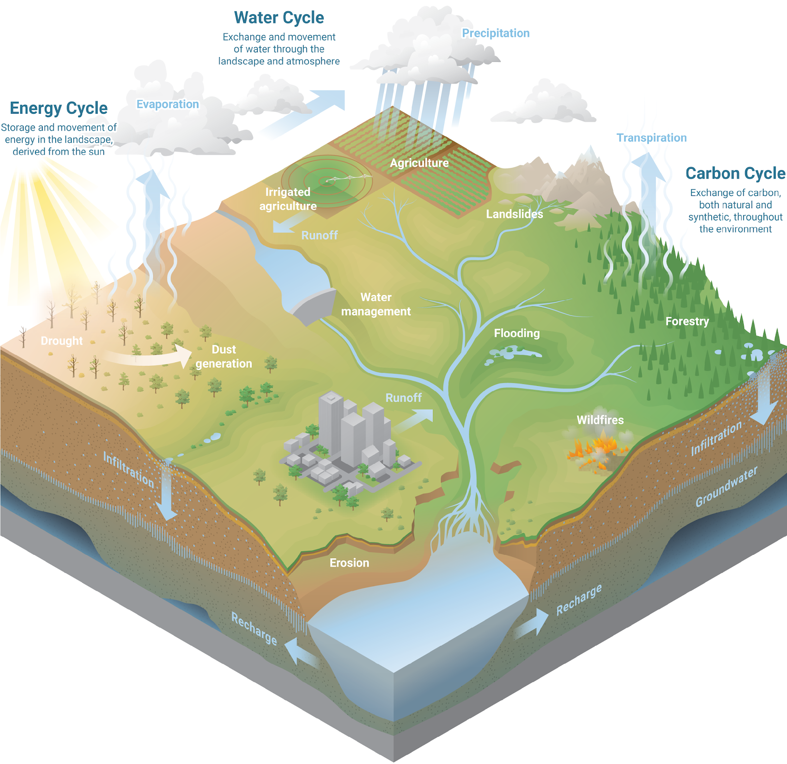
Soil moisture plays a central role in the water, energy, and carbon cycles. The level of soil moisture is determined by a host of factors beyond weather conditions, including soil type and associated vegetation. In turn, soil moisture levels affect a range of soil and plant dynamics.
When rain falls or snow melts, water soaks into the soil, where it may be held in place, taken up by plants, infiltrate deeper to recharge groundwater tables, or move across the land surface. Water is lost from the soil back to the atmosphere through evaporation or transpiration (the water plants use and release in photosynthesis). Wind, air temperature, relative humidity, and vegetation health all play roles in releasing soil moisture to the atmosphere.
Soil Moisture and Weather Impacts
Understanding how soil moisture interacts with weather and the landscape is useful for decision-making from a single agricultural field to an entire watershed basin. Soil moisture conditions are used in drought and flood forecasting, wildfire risk and burn planning, disaster response, farming and ranching operations, water supply management, construction operations, ecological resource management, and more.
Soil Moisture and Drought
Drought and soil moisture are closely linked, and monitoring soil moisture is a key component of monitoring and planning for drought. Changes in soil moisture can help predict drought onset or drought recovery. Additionally, because soil moisture is directly tied to plant health, ecological and agricultural drought are largely defined by soil moisture conditions.

How Soil Moisture Is Measured
Soil moisture is typically estimated using one of three approaches: in situ observations (data collected in place), modeling, or remote sensing.
Gravimetric sampling, a form of in situ data collection, is the most direct method of measuring soil moisture. To use this process, people collect a known volume of soil. They weigh the sample immediately after collection and again after baking the soil until it’s dry. The change in weight represents the volume of water lost between wet and dry conditions. However, this method is labor intensive and requires disturbing the landscape, so for repeat sampling, soil moisture is often estimated instead.
All other methods of soil moisture “measurement” are in fact proxies, using measurement of another variable to represent soil moisture. Some methods are highly accurate and highly localized, measuring the moisture of a very small volume of soil, while others estimate soil moisture on scales of hundreds or acres, or even hundreds of miles.
Depending on the intended use of the data, the most useful soil moisture information may be in situ, modeled, remotely sensed, or a mix of these estimates. It is important to note, however, that modeled and remotely-sensed data both rely on robust in situ datasets for validation and calibration.
In Situ (In-the-Ground) Soil Moisture Data
In situ (in-the-ground) soil moisture sensors provide precise estimates of soil moisture at specific depths. For this reason, in-field soil moisture sensors can be used by crop growers to support adaptive irrigation and improve water-use efficiency. The point-specific nature of these readings also makes soil moisture sensors valuable for calibration and validation of remotely-sensed or modeled conditions. In situ data can also be used for research and resource management focused on tracking water infiltration across different soil depths, identifying soil moisture response to wetting events, or tracking change in moisture over time.
However, in situ sensors only collect data for the small area of soil that surrounds them, and soil moisture conditions at a specific site location may not be representative of broader conditions at a landscape scale. Soil moisture is influenced by the soil’s texture and composition, slope of the landscape, plant root structure, how compact the soil is, vegetation cover, and more. In situ measurements even feet apart can yield different soil moisture values. Therefore, for understanding regional or basin-wide conditions, in situ data may be more valuable as a tool for calibration and validation of models or remotely-sensed data than as a stand-alone indicator of soil moisture.
An additional challenge is the short period of record associated with many soil moisture monitoring stations. Monitoring drought often involves comparing current conditions to what is normal for a region, which is difficult without a sufficient historical record for comparison. However, researchers are currently exploring machine learning and other methods to extend short periods of record and develop new approaches for communicating the links between soil moisture and drought.
Modeled Soil Moisture
Soil moisture models use calculations based on observed conditions (like precipitation and temperature) to simulate soil moisture conditions. Models can range from simple to complex, with different inputs, assumptions, and geographic coverage.
Modeled soil moisture can estimate average conditions across regions to allow for a landscape to basin-scale estimate of hydrologic conditions. However, models are less precise than in situ sensors in representing single point locations.
Remotely-Sensed Soil Moisture
Remote soil moisture sensors, including satellites, use microwave measurements, radars, or other technologies to estimate soil moisture across large areas of land. These sensors can provide frequent estimates of soil moisture, even in station-scarce areas.
However, many of these technologies only represent surface (top 5 cm) soil moisture, and the performance of some remote-sensing technologies declines for forested or complex, varied landscapes.
Key Takeaways

Soil Moisture for Drought Monitoring
Soil moisture can provide an early indicator of drought onset and can also be used to track drought persistence when dry conditions remain after rain events or across years. Additionally, monitoring soil moisture at multiple depths can reveal how far water infiltrates into the soil. When combined with information about plant root depth, this can indicate vegetation-specific water stress.
Flash Drought
Soil moisture can provide early warning of flash droughts—droughts that develop or intensify rapidly, on a scale of weeks rather than months. High temperatures, windy conditions, sunny skies, and low humidity can increase evapotranspiration. This lowers soil moisture, which decreases rapidly as drought evolves.
Agricultural Drought
Soil moisture is also useful for monitoring drought impacts to agriculture. Soil moisture, when considered alongside soil type, indicates the amount of water available to plants.
In-field soil moisture sensors can help producers carry out targeted, precision irrigation, while data from long-term networks can be integrated into drought warning and tracking systems. Such information has applications for rangeland management and grazing, crop planning and planting, and supporting private insurance claims.
Ecological Drought
Soil moisture can be a valuable tool for monitoring ecological drought. Soil moisture is linked to plant health and microbial activity. Extended periods of very dry soil conditions can impact plant health even after meteorological drought has ended. Dried out vegetation can act as fuel for wildfires, and recent research indicates that modeled soil moisture can be a useful indicator of wildfire spread. Consequently, soil moisture information has relevance for land use management, recreation, conservation, and wildfire management.
Hydrological Drought
Soil moisture plays a role in both surface water and groundwater recharge. During a rainfall or snow melt event, soils take up and hold a portion of the water, influencing what percentage of that moisture will reach streams, rivers, and reservoirs. Very wet soils only absorb a small portion of water, leading to high runoff. In general, drier soils will absorb more moisture, reducing runoff—but extremely dry or fire-damaged soils may become water repellent and contribute to rapid, high-volume runoff. Understanding the role of soil moisture in the water balance system can support planning for both droughts and floods, as well as reservoir operations.
Key Takeaways

Common Units for Soil Moisture
Absolute measures of soil moisture, such as volumetric water content (the volume of water per volume of soil), have different implications depending on soil texture, time of year, vegetation, or regional climate. For example, the same absolute soil moisture value in summer can indicate a serious drought in the Southeast, but represent normal soils in the drier Southwest. Interpreting soil moisture data requires assessing and maintaining a range of other “metadata,” particularly soil characteristics. It also means that more than one way of estimating soil moisture may be needed to best describe conditions.
As a result, scientists use several common units to measure soil moisture, including absolute measures of soil water content as well as metrics that consider soil type and plant health. Understanding the units soil moisture data are presented in is important to apply those values to decision-making or planning.
Volumetric Water Content
Volumetric water content (VWC) describes the volume of water per volume of soil. A VWC of 100% (or 1.0 m3/m3) represents pure water. A VWC of 0% (0.0 m3/m3) represents completely dry soils in which no water remains. Different soil types (e.g., clay, loam, sand) reach saturation (the maximum amount of water the soil can hold) at different volumes of water due to differences in soil characteristics.
For example, high clay soils bind more tightly to water molecules than sand or loam soils. In a loam soil with a measured VWC of 20%, plants may be able to extract water. However, in a high clay soil at the same reading of 20% VWC, water is difficult for plants to extract and uptake.
Fractional Available Water
Fractional available water (FAW) is a measure of the amount of moisture in the soil available to plants. Unlike volumetric water content, which is an absolute measure of the water in the soil, FAW takes the soil type into account. FAW is expressed as a fraction (from 0 to 1) or a percentage (0%–100%).
For FAW, 0% is the wilting point associated with the soil type (the soil moisture content at which plants have limited access to moisture), and 100% is the field capacity (the maximum amount of water the soil can hold). Since this measure is sensitive to soil type, FAW accounts for differences in soil properties across diverse regions and is a useful metric for agricultural drought.
FAW may reach values below 0% (water is present but not available to plants) or above 100% (more water than can be used by plants).
Soil Matric Potential
Soil matric potential refers to how tightly water is held in the soil and the energy required to move it. Soil water potential is expressed in units of pressure—kilopascals (kPa), megapascals (MPa), or bars—and represents the capillary pressure required for that water to be taken up by a plant. This metric includes soil texture, so measurements reported in these units can be compared across locations that may have different soils. Because different plants have different capacities to exert capillary pressure, their wilting points may vary.
Key Takeaways

Related Content
Soil Moisture Data & Maps
Soil moisture data, maps, and tools vary by the source of their input data, the depths they represent, and the metrics they display. Explore soil moisture products on Drought.gov.
Resources for Soil Moisture Network Operators
This page provides resources for managers and staff of long-term soil moisture monitoring networks. It addresses all steps of network management, from siting and installation to data quality control and long-term planning.
Stay Connected
Sign up for the National Coordinated Soil Moisture Monitoring Network (NCSMMN) email newsletter for updates on soil moisture research, virtual seminars, workshops, and opportunities for collaboration.
The National Coordinated Soil Moisture Monitoring Network
The National Coordinated Soil Moisture Monitoring Network (NCSMMN) is a community of network managers, researchers, data users, and others working to ensure high-quality, nationwide soil moisture information for the public good.