Droughts are often categorized as ‘flash’ droughts when they develop or intensify in a matter of weeks (though defining flash droughts continues to be an area of active debate). The National Integrated Drought Information System (NIDIS) and the National Weather Service (NWS) held a series of three webinars to help climate professionals and operational service providers better understand this phenomenon, its defining characteristics and how it varies by region and season, its impacts on agricultural and other stakeholders, and the potential for improved monitoring, prediction, and plann
This was the second of two webinars to share project findings on drought indices and indicators that support the monitoring and management of different drought types in the northeast United States. The webinar included an overview of several drought monitoring tools and data sources developed by the project team, including:
This webinar shared project findings on drought indices and indicators that support the monitoring and management of different drought types in the northeast United States. The objective of this two-year project was to identify the most effective drought indicators for hydrologic and agricultural drought monitoring in the NIDIS Northeast Drought Early Warning System (DEWS). This includes identifying appropriate time scales related to long-term and short-term drought, and identifying responsive indicators of flash drought development.
NOAA's National Integrated Drought Information System (NIDIS), the Desert Research Institute (DRI), and the Cooperative Institute for Research in Environmental Sciences at the University of Colorado Boulder (CIRES), in cooperation with the Northeast Region Climate Center (NRCC), are pleased to announce two upcoming webinars in September. In this webinar, the team will share their Drought Monitoring Toolbox for the Northeast.
Droughts are often categorized as "flash" droughts when they develop or intensify in a matter of weeks (though defining flash droughts continues to be an area of active debate). NIDIS and the National Weather Service hosted three flash drought webinars in 2021 to help climate professionals and operational service providers better understand this phenomenon, its defining characteristics and how it varies by region and season, its impacts on agricultural and other stakeholders, and the potential for improved monitoring, prediction, and planning/response tools (datasets, maps, etc.). Presentations for this webinar focused on emerging tools for flash drought monitoring and prediction from NOAA and other institutions.
The virtual 2021 National Soil Moisture Workshop provides a unique opportunity for leaders in soil moisture research and development to come together in an interactive workshop format to exchange ideas and develop collaborations. This will be the tenth consecutive year for the workshop, which is an initiative of the community of researchers that developed the Marena, Oklahoma, In Situ Sensor Testbed (MOISST).
South Dakota State University Extension will kick off its spring virtual educational programming with Drought Hour. Starting April 12, every Monday, participants are invited to take their coffee break online and stay ahead of drought impacts with climate updates, business insights, and research-tested management tips for farms, ranches, and properties of all sizes. Each week attendees can expect to hear reliable and timely climate updates, current drought conditions, and information to aid in drought management planning for their respective agriculture sectors.

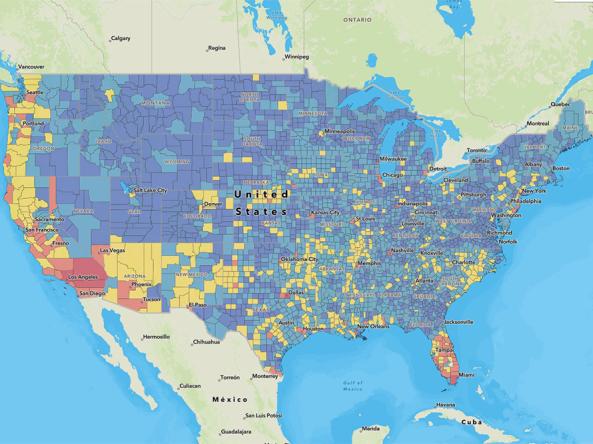
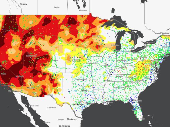
Nearly 50% of the Southwestern United States is currently experiencing the most severe drought classification (D4) conditions. The most recent U.S. Drought Monitor indicated that all of the Southwest was experiencing drought, and drought is expected to continue throughout the winter and into spring. This webinar will provide an update of current drought conditions and forecasts for Arizona, Colorado, New Mexico, Utah, and Nevada, followed by a demonstration of the new Drought.gov website.