Drought Continues to Intensify Across Portions of the Midwest
For details on the current conditions, view the July 21 North Central Climate and Drought Outlook Webinar (which be available on Friday, July 22 here).
Key Points
- Drought has rapidly intensified throughout the summer in portions of the Midwest (“flash drought”). Currently, 17% of the Midwest is in drought, which is 16% more than 5 weeks ago.
- The highest drought level in the region is extreme drought (D3), which is currently impacting northwest Iowa and southern Missouri.
- Current drought impacts include widespread vegetation stress (e.g., grass, plants, trees, crops), specifically in corn, where the hot and dry conditions have coincided with the reproductive phase, which will likely have a negative impact on yield.
- Other impacts include the need for irrigation to sustain crops, poor pasture conditions, increased wildfire risk, and the implementation of water conservation efforts by some municipalities in western Iowa.
- Forecasts show that portions of the region might get a short break from the excessive heat and dry conditions in late July through early August. Near- to above-normal rainfall would help ease the stress on agriculture and reduce wildfire risk.
- Despite the potential for some short-term relief, it is likely that hot and dry conditions will return to the region in August, and potentially continue through September and October as well.
- The U.S. Seasonal Drought Outlook (for July 21 through October 31) shows the likelihood of drought persistence across areas already in drought, and potential development of drought across northern Missouri, Iowa, and southern Minnesota.
Current U.S. Drought Monitor map for the Midwest Drought Early Warning System (DEWS) with data valid for July 19, 2022. The U.S. Drought Monitor (USDM) is updated each Thursday to show the location and intensity of drought across the country. Drought categories show experts’ assessments of conditions related to dryness and drought including observations of how much water is available in streams, lakes, and soils compared to usual for the same time of year.
U.S. Drought Monitor Categories
Abnormally Dry (D0)
Abnormally Dry (D0) indicates a region that is going into or coming out of drought. View typical impacts by state.
Moderate Drought (D1)
Moderate Drought (D1) is the first of four drought categories (D1–D4), according to the U.S. Drought Monitor. View typical impacts by state.
Severe Drought (D2)
Severe Drought (D2) is the second of four drought categories (D1–D4), according to the U.S. Drought Monitor. View typical impacts by state.
Extreme Drought (D3)
Extreme Drought (D3) is the third of four drought categories (D1–D4), according to the U.S. Drought Monitor. View typical impacts by state.
Exceptional Drought (D4)
Exceptional Drought (D4) is the most intense drought category, according to the U.S. Drought Monitor. View typical impacts by state.
Current U.S. Drought Monitor map for the Midwest Drought Early Warning System (DEWS) with data valid for July 19, 2022. The U.S. Drought Monitor (USDM) is updated each Thursday to show the location and intensity of drought across the country. Drought categories show experts’ assessments of conditions related to dryness and drought including observations of how much water is available in streams, lakes, and soils compared to usual for the same time of year.
Current Conditions and Impacts
Current Conditions
- Drought has rapidly intensified this summer throughout portions of the Midwest. Drought has intensified by at least one category over the last four weeks in some portion of all Midwest states, according to the U.S. Drought Monitor. Parts of Missouri and western Kentucky have had drought intensify by three categories (Figure 1).
- Currently, 17% of the region is in drought, with the most intense pockets of moderate to extreme drought (D1–D3) in northwestern Iowa and southern Missouri. Other areas in moderate to severe drought (D1–D2) are central Illinois, western Kentucky, and central Minnesota.
- Recent extreme heat along with below-normal rainfall (Figure 2) has been the main driver for the rapid intensification of drought. Since June 1, multiple cities across the region have ranked within the top 10 for the number of days above 95°F, including Joplin, MO (22 days), St. Louis, MO (11 days), and Minneapolis–St. Paul, MN (4 days).
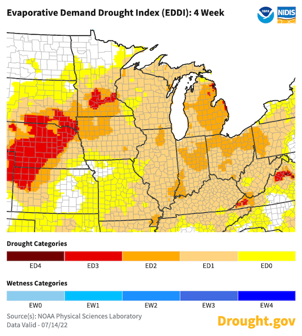
- The extreme heat has increased evaporative demand (or the “thirst” of the atmosphere) over the last month, which is shown through high Evaporative Demand Drought Index (EDDI) values, particularly across Minnesota (Figure 3). When evaporative demand is high, any rain that does fall on the landscape is likely to evaporate. When moisture is not available, crops will become stressed.
Figure 1. 4-Week Change Map for the U.S. Drought Monitor
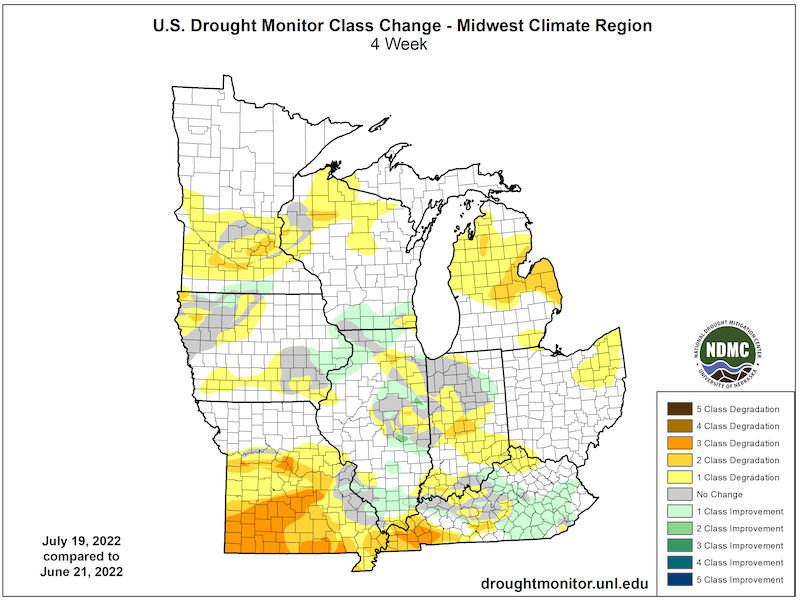
Figure 2. 30-Day Percent of Normal Precipitation (June 22–July 21, 2022)
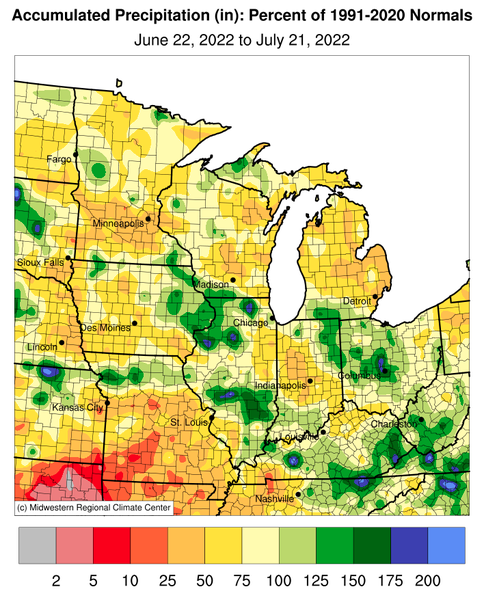
Figure 3. Evaporative Demand Drought Index (EDDI) for 4 Weeks Ending July 14, 2022
Drought Impacts
- A leading impact of rapid intensification drought, or “flash drought”, is a rapid decline in soil moisture (Figure 4), which leads to increased stress on vegetation (Figure 5). Vegetation stress is being observed at various scales across the region—from backyards to fields of crops.
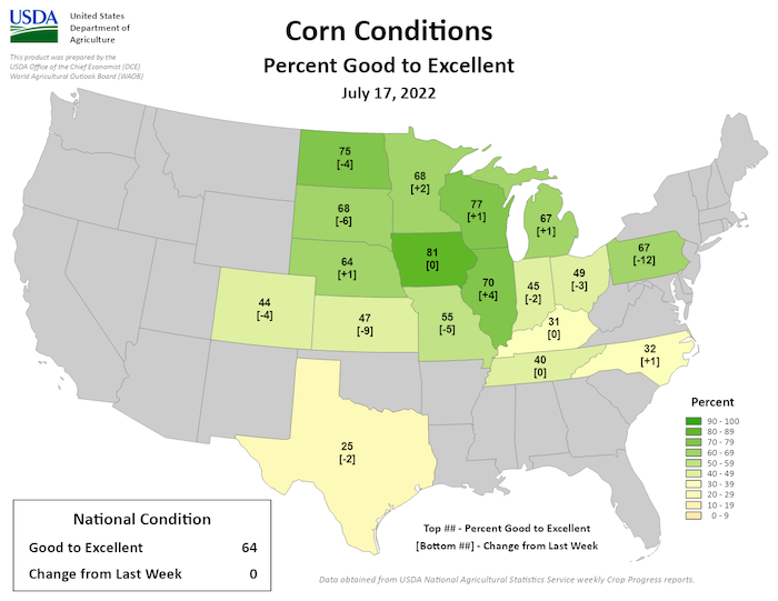
- Drought stress has been apparent in corn in some areas of the Midwest (northwest Iowa, Minnesota, Illinois, Missouri, Indiana, and Kentucky). While the scope of damage will not be known for some time, it is likely that yields could be affected since the recent hot and dry weather has coincided with the corn’s reproductive stage.
- Despite the hot and dry conditions, the majority of corn is reported to be in good to excellent condition across the region (Figure 6). Kentucky, Indiana, Ohio, and Missouri are reporting lower percentages of corn in good to excellent condition. There are some reports of stressed soybeans in Iowa, but soybeans are more resilient to drought during this time of year.
- Pasture conditions are very poor across Missouri, providing almost no feed for livestock. Supplemental feeding is required in order to maintain livestock condition. Surface water for livestock is also limited.
- The hot and dry conditions have affected specialty crops. In Kentucky, the heat has killed apple trees and affected the quality of apples, and in Michigan, many growers are having to rely upon irrigation in order to avoid negative impacts.
- Wildfire risk has increased due to the hot and dry conditions, and some local areas have had to implement burn bans in Indiana, Missouri, and Michigan as a result.
- While there are no widespread concerns about municipal water supply, some cities in western Iowa (including Sioux City, Iowa) are implementing water conservation measures.
Report your drought impacts through the Condition Monitoring Observer Reports (CMOR):
Figure 4. NASA SPoRT-LIS 0–100cm Soil Moisture Percentiles (valid July 21, 2022)
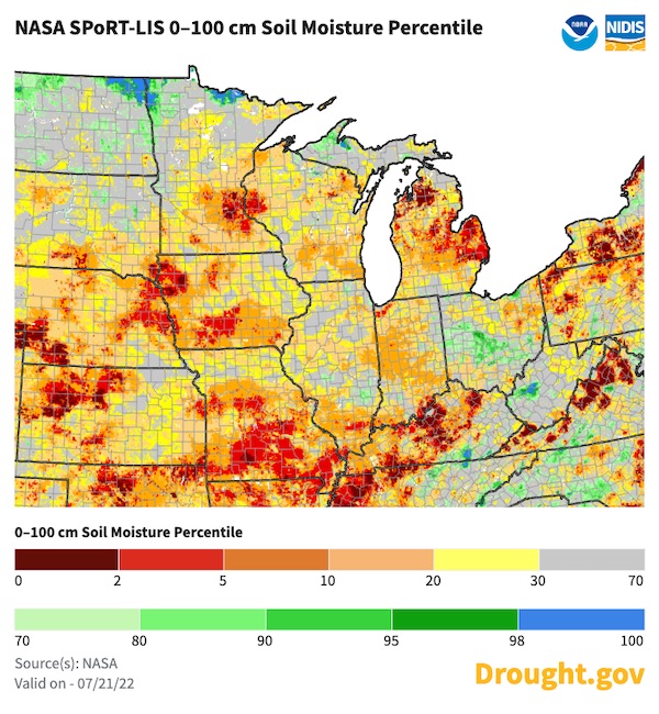
Figure 5. QuickDRI for the 4 Weeks Ending July 17, 2022
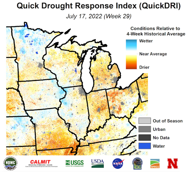
Figure 6. USDA-NASS Crop Condition Report for July 17, 2022
Outlook and Potential Impacts
- The excessive heat is expected to continue over the next 3–7 days, particularly across southern portions of the Midwest (Missouri, Illinois, and Kentucky).
- After this, however, it looks like parts of the Midwest might get at least a short break from the excessive heat and dry conditions. Forecasts are showing an increased chance for near- to above-normal precipitation in the late July to early August time frame (Figure 7).
- Near- to above-normal rain and a break from the oppressive heat will likely limit the worsening of crop conditions, ease wildfire risk, and provide some replenishment of surface water for livestock. However, the scattered nature of rainfall means areas that see some relief could be fairly localized.
- Despite the potential for some short-term relief, it is likely that hot and dry conditions will return to the region in August (Figure 8). Below-normal precipitation in August could be harmful to soybeans, as this is a critical time for precipitation.
- Looking at the August through October time frame, seasonal outlooks are showing a greater chance for above-normal temperatures and below-normal precipitation, which is likely to cause drought to persist in areas already experiencing drought, and drought expansion across northern Missouri, Iowa, and southern Minnesota (Figure 9).
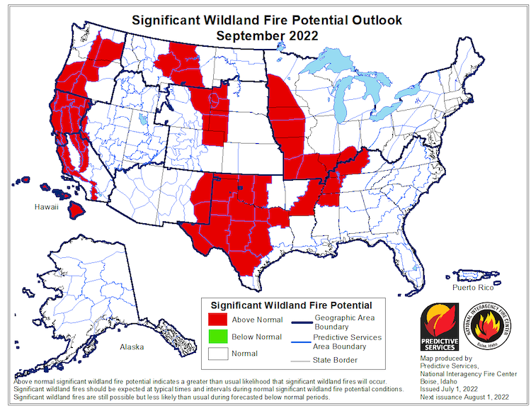
- As a result of the seasonal outlook, the September 2022 Significant Wildland Fire Potential Outlook is showing chances for above-normal fire potential across western and southern portions of the region (Figure 10).
- Potential impacts of drought persistence through late summer and early fall could include the increased hydrological impacts (e.g., streamflow, groundwater) if drought lasts for multiple months, which could lead to ecological impacts as well with reduced availability of surface water.
Figure 7. 8-14 Day Precipitation Outlook (Valid July 29-August 4, 2022)
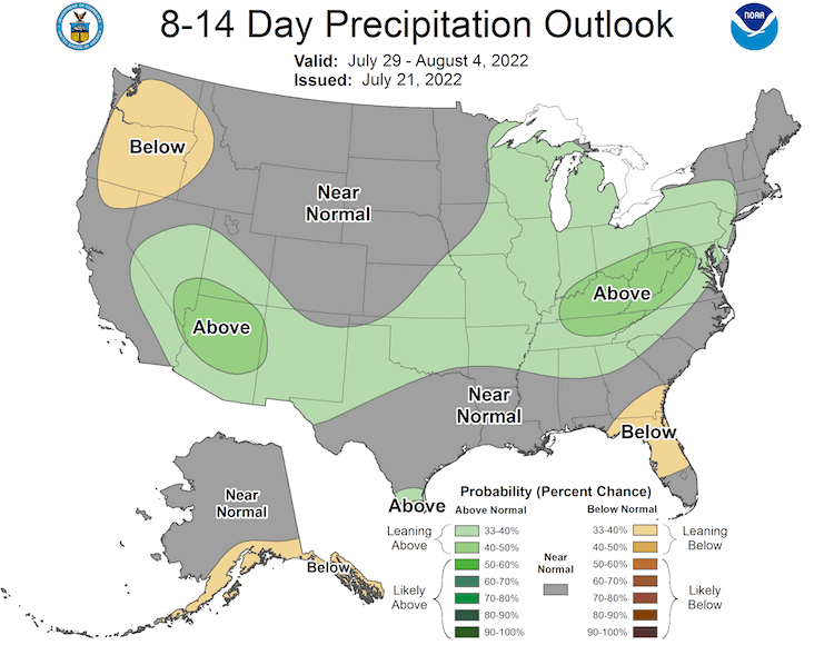
Figure 8. Monthly Precipitation Outlook for August 2022
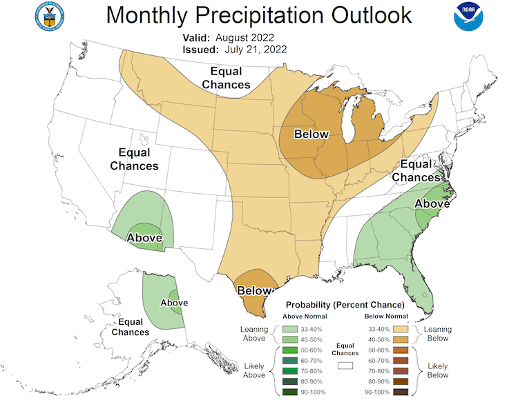
Figure 9. U.S. Seasonal Drought Outlook for July 21–October 31, 2022
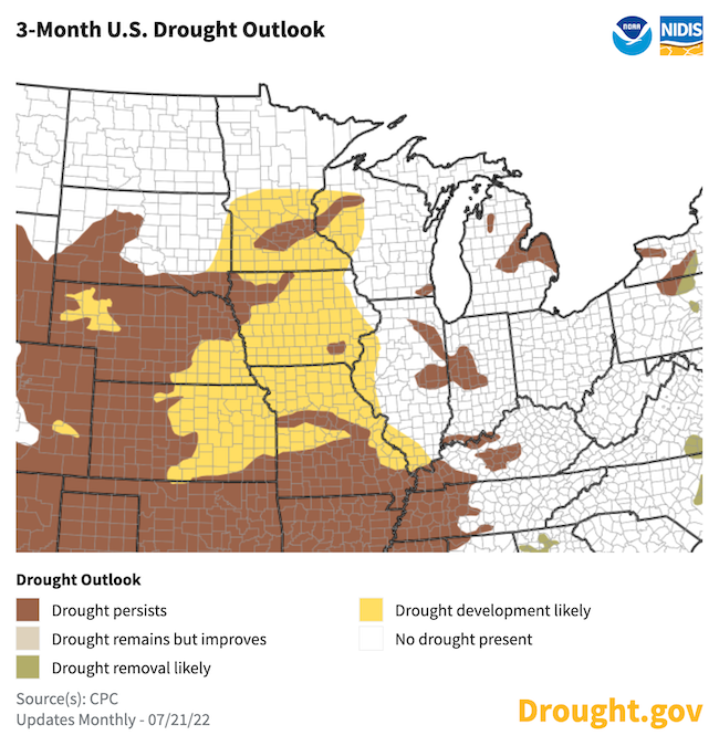
Figure 10. Significant Wildland Fire Potential Outlook for September 2022
For More Information
- NIDIS and its partners will issue future updates as conditions evolve.
- More local information is available from the following resources:
- To report or view local drought impact information:
- Report your drought impacts through Condition Monitoring Observer Reports (CMOR)
- View CoCoRaHS Condition Monitoring reports.
- The upcoming North Central U.S. Climate and Drought Summary & Outlook Webinar on August 18, 2022 will offer updated information about conditions, impacts, and outlooks. The recordings for the webinar can be found here.
Prepared By
Molly Woloszyn
NOAA/National Integrated Drought Information System (NIDIS), CIRES/University of Colorado Boulder
Dennis Todey
USDA Midwest Climate Hub
Doug Kluck
NOAA/National Centers for Environmental Information
Melissa Widhalm
Midwestern Regional Climate Center/Purdue University
Ray Wolf & Audra Bruschi
NOAA/National Weather Service
This drought status update is issued in partnership between the National Oceanic and Atmospheric Administration (NOAA) and the U.S. Department of Agriculture (USDA) to communicate a potential area of concern for drought expansion and/or development within the Midwest U.S. based on recent conditions and the upcoming forecast. NIDIS and its partners will issue future drought status updates as conditions evolve.

