It’s raining and snowing in parts of the Intermountain West, but drought continues.
Key Points
- Extreme drought conditions continue in the Intermountain West, and new drought conditions developed in eastern Colorado.
- Autumn precipitation has been beneficial for locations west of the Continental Divide, but is lacking east of the Divide.
- La Niña has developed and has an 80%–90% chance of continuing this winter, December 2021 to February 2022. This usually means less snow for the Southwest.
Current U.S. Drought Monitor map for the Intermountain West Drought Early Warning System region with data valid for October 26, 2021. The U.S. Drought Monitor is updated each Thursday to show the location and intensity of drought across the country.
Recent precipitation has improved drought conditions across the Intermountain West, but Extreme (D3) to Exceptional (D4) drought persists.
U.S. Drought Monitor Categories
Current U.S. Drought Monitor map for the Intermountain West Drought Early Warning System region with data valid for October 26, 2021. The U.S. Drought Monitor is updated each Thursday to show the location and intensity of drought across the country.
Recent precipitation has improved drought conditions across the Intermountain West, but Extreme (D3) to Exceptional (D4) drought persists.
Recent and Current Conditions
U.S. Drought Monitor Conditions
- As of October 26, 26% of the Intermountain West is in Extreme to Exceptional (D3–D4) drought.
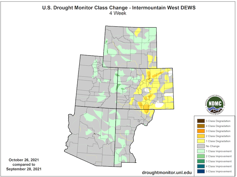
- Over the past four weeks, drought conditions have improved but remain in Arizona, New Mexico, and Utah.
- Despite the small improvement, Severe (D2) to Extreme (D3) drought remains in all states in the Intermountain West.
- Exceptional (D4) drought remains in Utah and Colorado.
- Drought conditions have remained or deteriorated in eastern Colorado and southeast and northern Wyoming.
U.S. Drought Monitor 4-Week Change Map
Recent Precipitation
- September precipitation for the Intermountain West:
- Precipitation was near average for Arizona.
- Precipitation was a little below average for Colorado, New Mexico, Utah, and Wyoming.
- Overall, precipitation was slightly below average for Colorado, where western Colorado had above-average precipitation and eastern Colorado was exceptionally dry for the month.
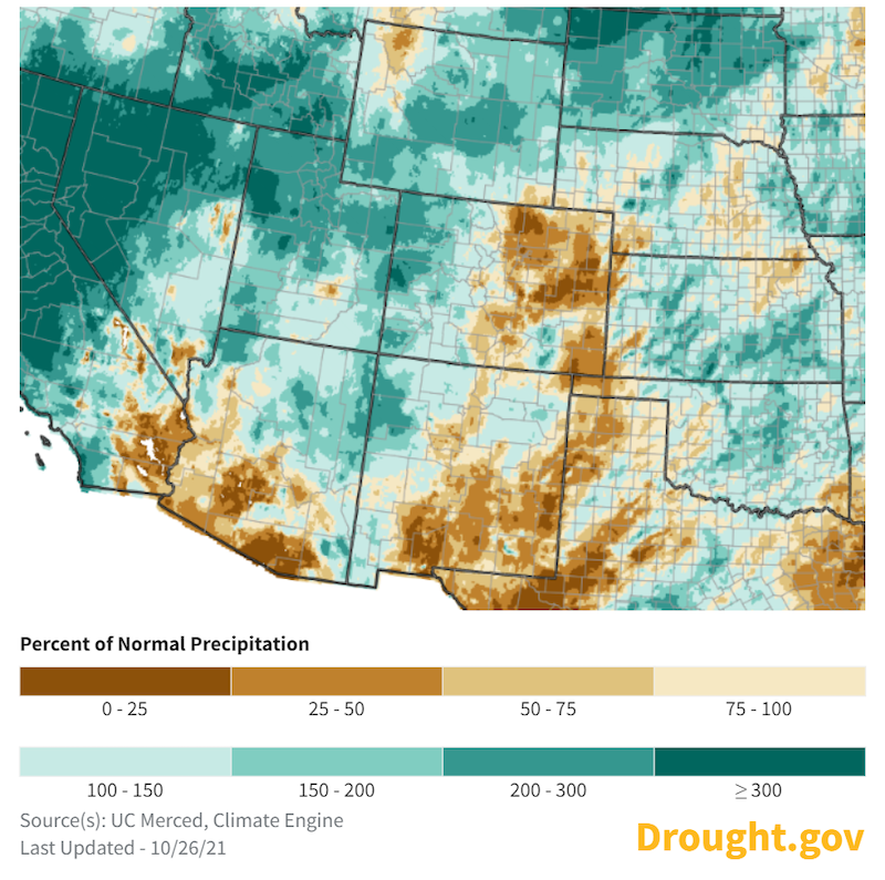
- October precipitation for the Intermountain West:
- There was above-average precipitation for northern Utah, central Wyoming, Colorado’s western slopes, and along the Arizona/New Mexico border.
- There was below-normal precipitation for October for southern Arizona, eastern Colorado and New Mexico, and Wyoming's Park county.
- There were two wildfires during October in southern Arizona.
- A recent atmospheric river has brought precipitation to the western U.S, including parts of the Great Basin and northern Utah.
- See this special update for more information about this event and what it means for drought in California, Nevada, and the Pacific Northwest.
- Learn more about atmospheric rivers at NOAA: What is an atmospheric river? and this USDA Southwest Climate Hub podcast episode on the topic.
30-Day Percent of Normal Precipitation
Forecasts and Seasonal Outlooks
Climate Patterns: La Niña Advisory
- NOAA’s El Niño–Southern Oscillation (ENSO) alert system status is currently at La Niña Advisory—meaning La Niña conditions have been observed and are expected to continue the next few months.
- La Niña usually correlates with below-normal winter precipitation in the Southwest U.S. For example, since the 1949/1950 winter there have been 24 La Niña winters. Of these, 3 had above-average rainfall and 21 had below-average rainfall for Tucson, AZ.
- Seasonal forecasts also show a drying pattern across the Southwest, consistent with a La Niña pattern.
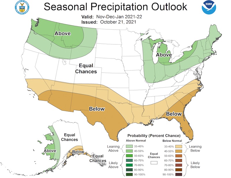
3-Month Outlook (November 2021–January 2022)
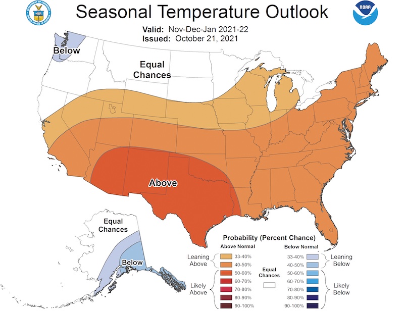
A warm and dry autumn is likely for the Intermountain West.
November–January Temperature Outlook
November–January Precipitation Outlook
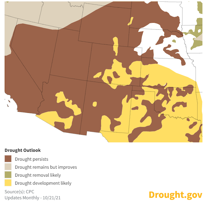
Seasonal Drought Outlook
Despite short-term drought improvement, the Climate Prediction Center's 3-month drought outlook shows drought continuing at least through winter.
U.S. Drought Outlook: October 21, 2021–January 31, 2022
State-Based Conditions and Impacts
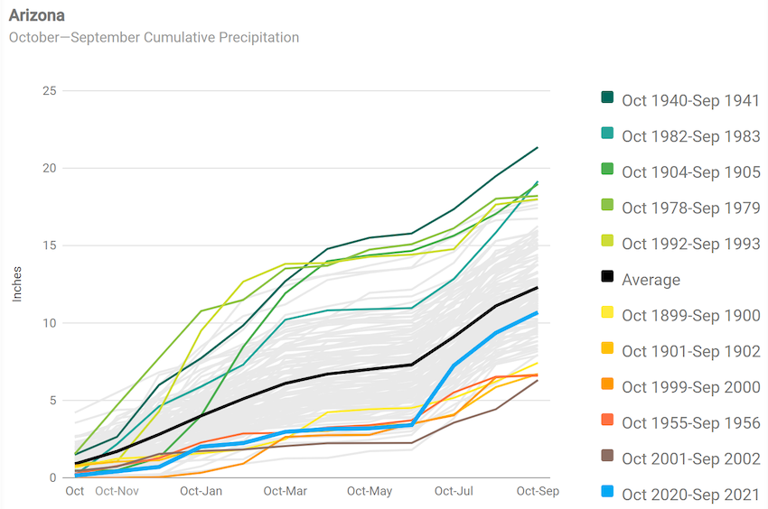
Arizona
- Drought conditions continued improving through October, with only 9% of the state in Extreme (D3) drought. Abnormally Dry (D0) conditions increased to over 23% of the state. The last measure of Exceptional (D4) drought occurred at the end of August (at 1%).
- The 2021 Water Year ended with below-average precipitation for the state, at 10.69 inches (1.6 inches below the long-term average of 12.3 inches). Both Pima and Santa Cruz counties ended the water year above average. All other counties were below average.
- Snow has already been measured in the higher elevations in the northern and eastern portions of the state, including snow events on September 30 and October 11–13.
Arizona October–September Cumulative Precipitation
Colorado
- Colorado has seen mixed conditions in October. Conditions west of the Continental Divide have been cooler and wetter than normal, while conditions in the eastern plains have been warmer and drier than normal.
- October/November is the closest Colorado has to a drought “off season.” We are encouraged by recent rain events in western Colorado, but now is the time when we shift from thinking about growing season impacts to what this year’s snowpack will bring.
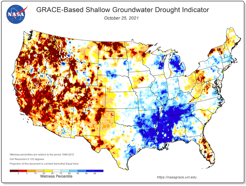
- It is likely that well over 100% over snowpack will again be needed for a normal runoff in 2022. We have seen some shallow soil moisture and base flow recovery in western Colorado, but according to NASA GRACE satellite data, our high-elevation groundwater is still well below normal.
- A recent impact report from the Farm Service Agency in Kiowa County (southeast Colorado) noted that harvest conditions were mixed. Producers who missed the rains earlier this season had lower wheat yields, but many farmers are finishing the harvest with above-average yields and above-average grain prices, a rare and fortuitous combination.
GRACE-Based Shallow Groundwater Drought Indicator
New Mexico
- The Monsoon brought short-term improvement, but long-term Drought continues
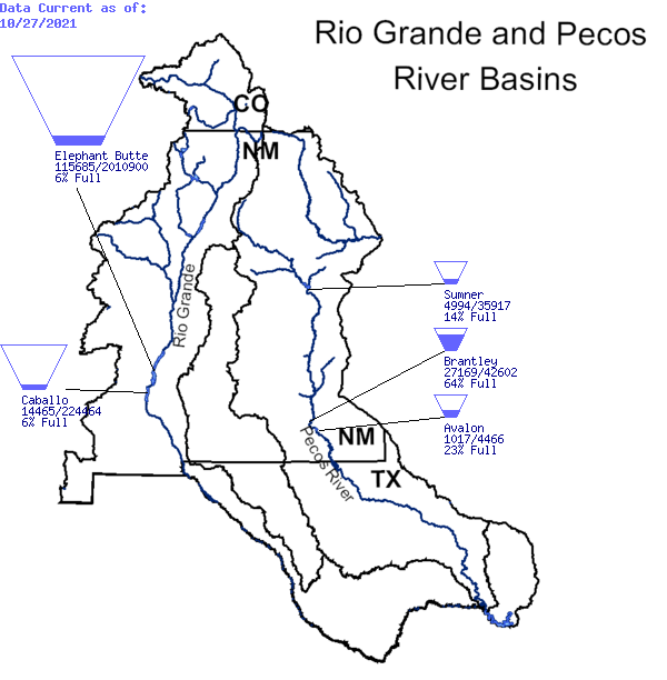
- Reservoir storage in New Mexico still indicates long-term drought conditions persist. Elephant Butte and Caballo reservoirs, on the Rio Grande, are both at 6% full.
Reservoir Storage: Rio Grande and Pecos River Basins
Utah
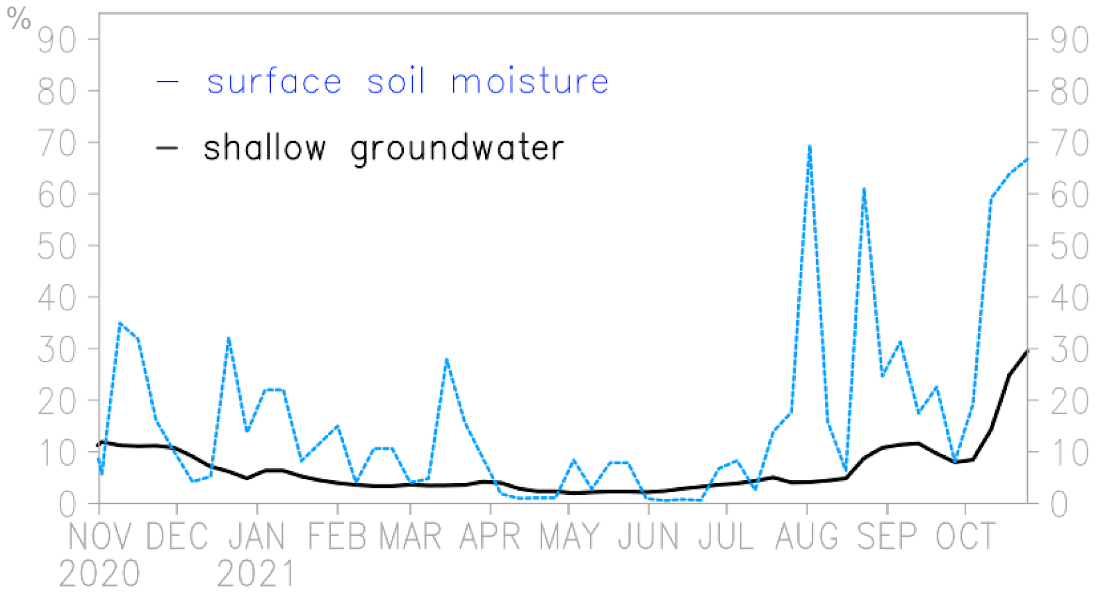
- A cool and wet fall drove drought improvements, with the continuation of good soil moisture ahead of snowpack accumulation.
- Recent episodes of heavy fall precipitation did elevate soil moisture and started to increase the shallow groundwater towards a buildup of the water storage deficit.
- Despite the signs of drought improvement, Utah would need 166% of normal precipitation between November and April for Utah to break out of drought.
Utah Soil Moisture Conditions
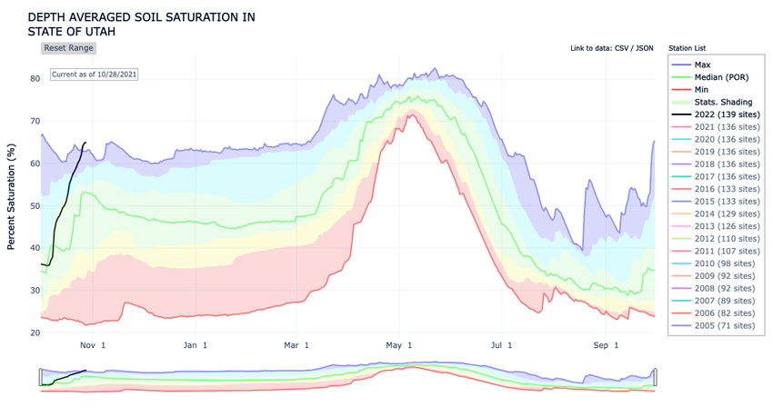
Utah Soil Moisture and Groundwater Percentiles
Wyoming
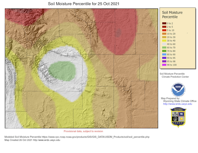
- Snow has continued to fall on many parts of Wyoming during October and, with soil temperatures still above freezing, subsequent melting has led to improved soil moisture conditions statewide.
- Temperatures:
- Average temperatures across the state have been coolest in the west and southwest in October, reaching as much as 3 ºF below average. Meanwhile, parts of the northeast and east have been as much as 6 ºF above average.
- Generally, nighttime temperatures have been more above their average than the daytime highs have been.
- Precipitation has been above average for most of the state, with much of Wyoming receiving more than 130% of average and the central areas approaching 300% of average. Park and Laramie counties have been the exceptions, with precipitation as low as 50% of normal. Large parts of Teton and Uinta Counties have also been below normal, but to a lesser extent.
Wyoming Soil Moisture Percentile: October 25, 2021
For More Information
More local information is available from the following resources:
In Case You Missed It
- October 26, 2021: Southwest Drought Briefing
- September 21–22, 28–29, 2021: Southwest Drought Forum
- New Video: Living With Drought and Increasing Aridification in the Southwest
Upcoming Events
- November 23, 2021: Southwest Drought Briefing. More details to come.
- December 2, 2021, 10 a.m.–12 p.m. MST: Drought Monitoring and Reporting in Arizona: Building a Network for Drought Response (Virtual Workshop). Register here.
- December 7, 2021, 2-3:30 p.m MST: Southwest Drought Learning Network Quarterly Meeting. Contact joel.lisonbee@noaa.gov for more information.
Prepared By
Joel Lisonbee
NOAA/National Integrated Drought Information System (NIDIS)
Greg Heavener
Warning Coordination Meteorologist, National Weather Service, Pueblo, Colorado
Erin Saffell
Arizona State Climatologist/Arizona State University
Erin Boyle
Service Hydrologist, National Weather Service, Tucson, Arizona
Peter Goble
Colorado Climate Center/Colorado State University
Simon Wang
Utah Climate Center/Utah State University
Tony Bergantino
Water Resources Data System – Wyoming State Climate Office
This drought status update is issued in partnership between the National Oceanic and Atmospheric Administration (NOAA), and the offices of the state climatologist for Arizona, Colorado, New Mexico, Utah and Wyoming. The purpose of the update is to communicate a potential area of concern for drought expansion and/or development within the Intermountain West based on recent conditions and the upcoming forecast. NIDIS and its partners will issue future drought status updates as conditions evolve.