Despite a Wet Summer, Pockets of Extreme (D3) to Exceptional (D4) Drought Continue
Key Points
- Fall is expected to see a return to relatively warm and dry conditions for the season.
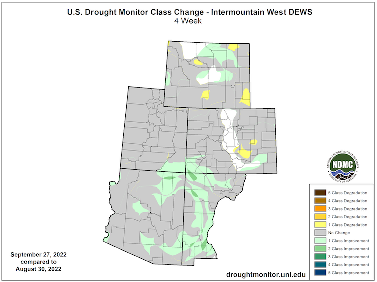
- An active summer monsoon pattern has improved short-term drought conditions across the Intermountain West, but long-term drought conditions persist.
- The area in severe (D2) to exceptional (D4) drought is at its lowest in two years.
Current U.S. Drought Monitor map for the Intermountain West Drought Early Warning System (DEWS) region with data valid for September 27, 2022. The U.S. Drought Monitor is updated each Thursday to show the location and intensity of drought across the country.
12.34% of the Intermountain West DEWS region is experiencing extreme to exceptional drought (D3–D4), the lowest amount since August 2020.
U.S. Drought Monitor Categories
Current U.S. Drought Monitor map for the Intermountain West Drought Early Warning System (DEWS) region with data valid for September 27, 2022. The U.S. Drought Monitor is updated each Thursday to show the location and intensity of drought across the country.
12.34% of the Intermountain West DEWS region is experiencing extreme to exceptional drought (D3–D4), the lowest amount since August 2020.
Current Drought Conditions and Outlook
U.S. Drought Monitor Conditions
- An active summer monsoon pattern has improved short-term drought conditions across the Intermountain West.
- Exceptional (D4) drought persists in central Utah and northeastern Colorado.
- 12.3% of the region is experiencing Extreme (D3) drought or worse, the lowest amount since August 2020.
- Extreme (D3) drought conditions have been in place in this region since May 2020.
- Moderate (D1) or worse drought has been in the region since August 2009.
U.S. Drought Monitor 4-Week Change Map
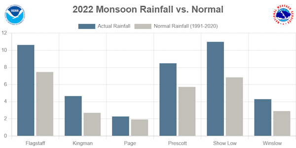
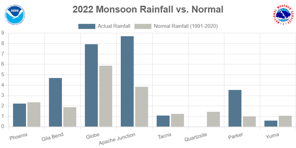
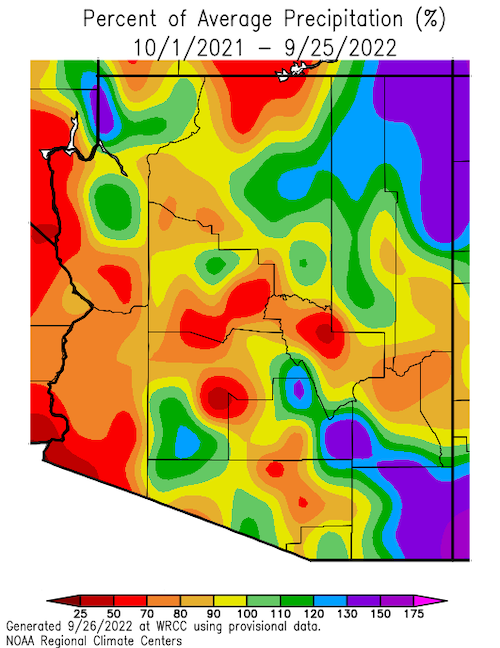
Southwest Monsoon Summary
Rainfall totals for the Southwest have been mostly average to above average for the monsoon season so far.
Arizona Monsoon Rainfall vs. Normal
Southeastern Arizona:
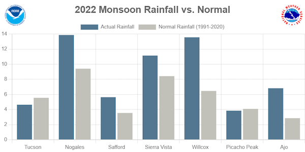
Northern Arizona:
Central Arizona:
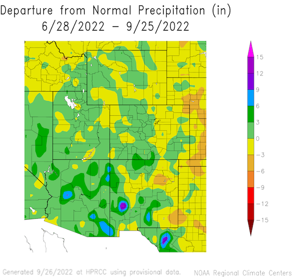
60-Day Departure from Normal Precipitation
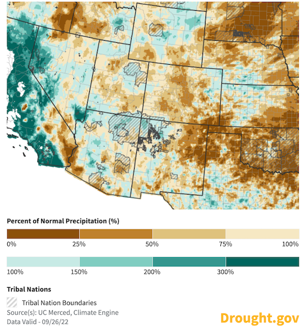
30-Day Percent of Normal Precipitation
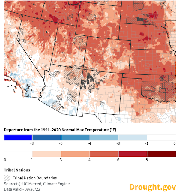
30-Day Departure from Normal Maximum Temperature (ºF)
Forecasts and Seasonal Outlooks
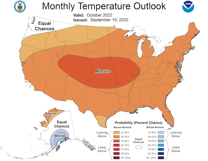
October 2022
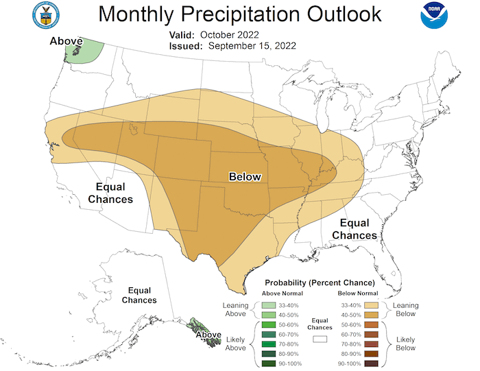
The Climate Prediction Center's monthly outlook for October shows:
- Increased temperatures are highly likely across most of the U.S., including the Intermountain West region, with the highest odds over Colorado and eastern Utah.
- The monthly outlook for October shows an equal chance of above- or below-average precipitation is likely for Arizona; below-normal precipitation is likely for Wyoming, Utah, Colorado, and New Mexico.
October 2022 Temperature Outlook
October 2022 Precipitation Outlook
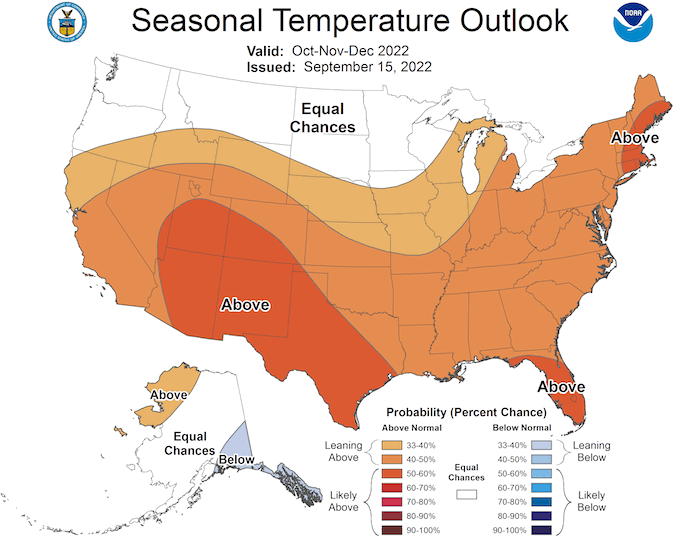
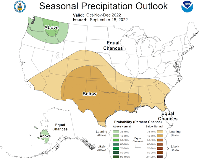
3-Month Outlook for October–December 2022
- Seasonal forecasts for October–December show a warmer-than-normal season ahead for the Intermountain West.
- Lower-than-normal precipitation is more likely for New Mexico and southern Colorado.
Three-Month Temperature Outlook: October–December 2022
Three-Month Precipitation Outlook: October–December 2022
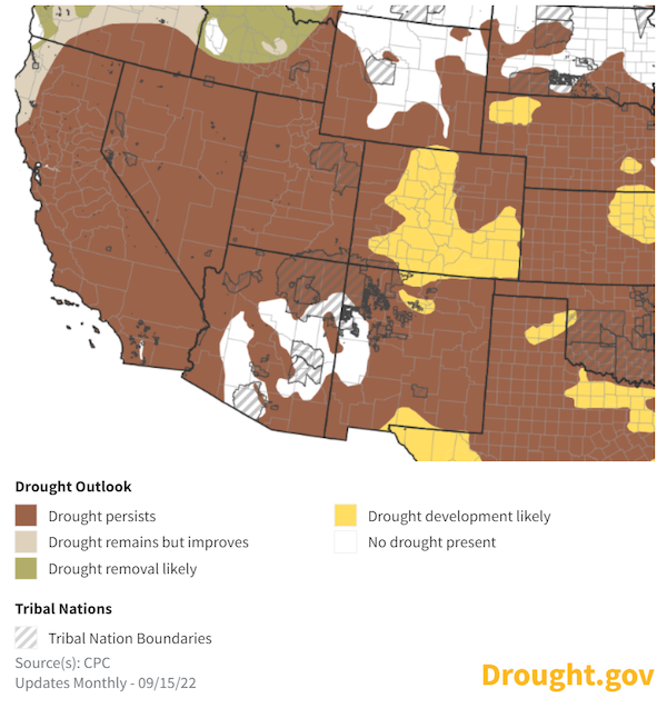
Seasonal Drought Outlook
- Any improvements from the immensely beneficial summer monsoon to the Intermountain West drought have likely been realized.
- The Climate Prediction Center's seasonal drought outlook shows a relatively warm and dry autumn ahead.
- The seasonal drought outlook shows that short-term drought will likely persist for Arizona and New Mexico and Utah
- Drought is likely to develop for the currently drought-free regions of central and southern Colorado.
- Long-term drought will continue in the region.
September 15–December 31 Drought Outlook
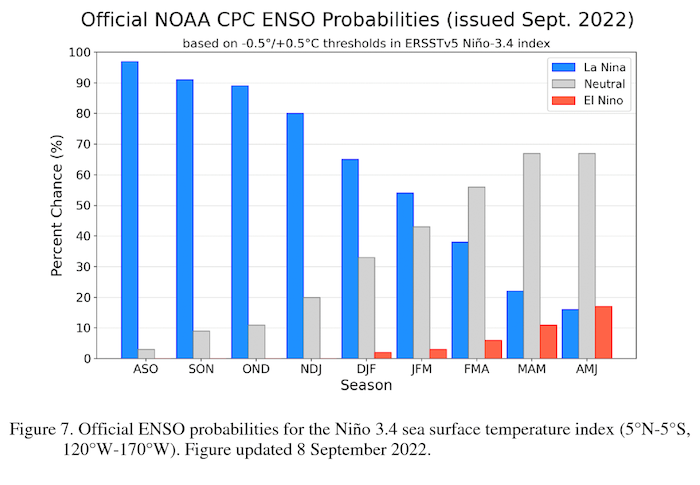
La Niña Persists and May Impact Winter Weather
- One of the primary drivers of drought across the Southwest through the winter ahead will be a third consecutive year of a La Niña pattern in the Pacific.
- The latest CPC El Niño–Southern Oscillation (ENSO) discussion maintains a La Niña Advisory. La Niña is favored to continue through the Northern Hemisphere winter 2022–23, with a 91% chance in September–November, decreasing to a 54% chance in January–March 2023.
- No two La Niña patterns are the same. For more information, please check out the NOAA ENSO blog.
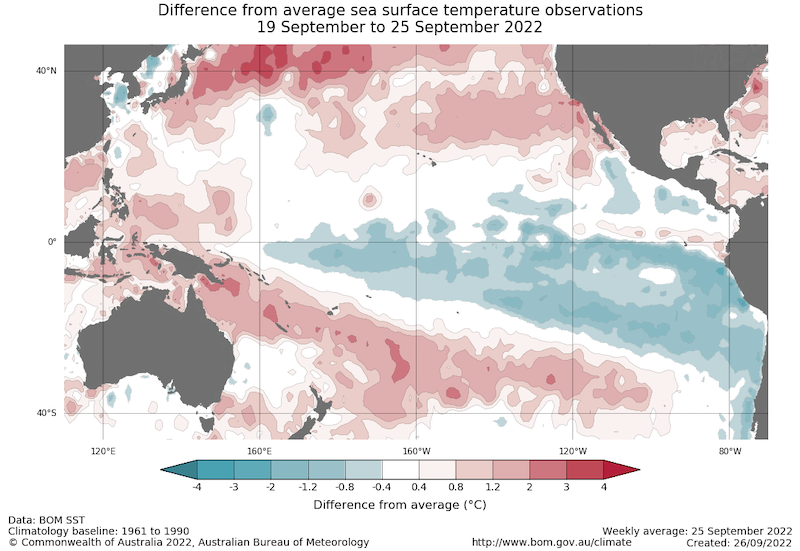
Sea Surface Temperature Anomalies (°C) for September 19–25, 2022
Probability of El Niño, La Niña, or Neutral Conditions
State-Based Conditions and Impacts
Arizona
- September transitioned from the monsoon season with two events. Remnants of Hurricane/Tropical Storm Kay brought precipitation largely to the southwestern portion of the state (September 9–11), while a cutoff low-pressure system brought precipitation across the state (September 20–22). .
- Nearly 81% of the state now has abnormally dry (D0) conditions or moderate drought (D1). The state no longer shows extreme (D3) or exceptional (D4) drought.
- Northern and central Arizona received average to above-average precipitation for September. Largely due to a wet December and wet monsoon season, many areas of the state received average to above-average precipitation for Water Year 2022.
Colorado
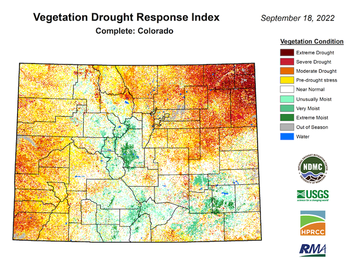
- Colorado experienced its 14th warmest August since 1895 (3rd warmest in the last decade). Precipitation was near normal.
- Moisture was above average this summer in the High Country, but much below normal on the northeast plains. Satellite-derived vegetative health shows severe or extreme drought in the northeastern corner of the state. The area did receive 1.00–1.50 inches of rainfall on September 22 and 23. This is too late for significant improvements to current crops, but ideal for planting winter wheat for next year.
- 28-day average streamflows across the state are varied, but have returned to near-normal levels. Colorado should start this snowpack season with higher river base flows than the previous two years.
New Mexico
- Catron and Rio Arriba Counties, New Mexico, had their wettest summer (June, July, August) on record with 11.28 inches and 10.29 inches of precipitation, respectively, over the three-month period.
- Precipitation through summer was split, with the western half of the state experiencing much-above-average precipitation while the eastern half of the state had below-average precipitation.
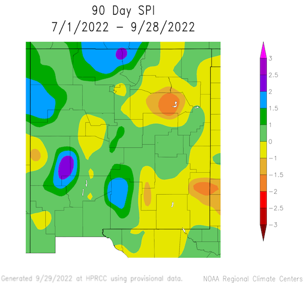
90-Day Standardized Precipitation Index
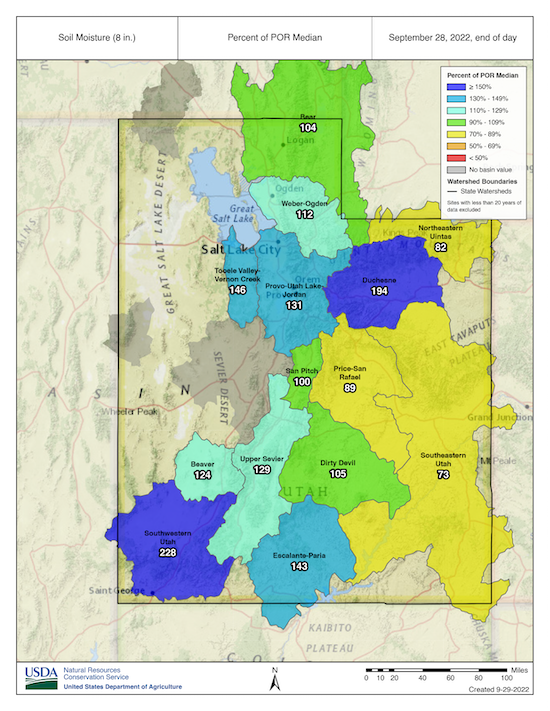
Utah
- Short-term drought improvements reflect the above-average monsoon season and limited evaporative demand extending into the start of Fall.
- All but southeastern Utah soil moisture stands well-above normal for this time of year, leading to optimism for high streamflow efficiency for the 2023 spring runoff season.
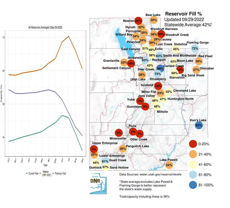
- Reservoir levels remain highly depleted across all but northern Utah watersheds, with meaningful hydrologic improvements not expected through the next year as a third La Niña presents the likelihood for warm and dry conditions this winter.
Wyoming
- Precipitation:
- Wyoming received its first snow of the season on September 10, with accumulations in the Wind River and Absaroka Ranges as well as the Bighorns. Snow lingered about three days, but subsequent snows have fallen since, and Wyoming is ending Water Year 2022 with amounts existent in the Wind River Range and Owl Creek Mountains.
- Central and northeastern Wyoming received above-median precipitation for the month, while much of the south, east-central, and, to a lesser extent, parts of the northwest were below median.
- Soil Moisture:
- Southeastern Wyoming is still experiencing soil moisture levels in the 10th or less percentile.
- Levels in the Powder River Basin have improved from the 10th–20th percentile to the 30th–40th.
- Conditions in east-central Wyoming, which were at or above median at the start of the month, have deteriorated to the 10th to 30th percentile, with slightly less worsening in the southwest.
- Temperatures:
- Mean temperatures across the state for September were mostly 3℉–6℉ above average. Some areas of northwestern and north-central Wyoming were up to 10℉ above average.
- Cooler minimum temperatures were offset by warmer than average maximum temperatures, especially in the western part of the state.
- Drought:
- While there has been some improvement in central and north-central Wyoming, conditions in the southeast have been degraded with extreme drought (D3) covering more of Laramie County and extending into Platte and Goshen Counties during the last week of the month.
For More Information
More local information is available from the following resources:
- Your state climatologist
- Your local National Weather Service office
- Western Water Assessment: Intermountain West Climate Dashboard
- Climate Assessment for the Southwest: Southwest Climate Outlook
In Case You Missed It
- September 8, 2022: Drought Prediction: Water Availability Prediction for Ecosystems - End User Listening Session
- September 13, 2022: Southwest Drought Briefing
Upcoming Events
- October 11, 2022, 1 p.m. MT: Southwest Drought Briefing
- October 20, 2022, 1–2 p.m. ET: National Listening Session Series Key Takeaways and Next Steps: Drought Prediction and Water Availability
Prepared By
Joel Lisonbee
NOAA/National Integrated Drought Information System (NIDIS)
Erin Saffell
Arizona State Climatologist/Arizona State University
Peter Goble
Colorado Climate Center/Colorado State University
Jon Meyer
Utah Climate Center/Utah State University
Tony Bergantino
Water Resources Data System – Wyoming State Climate Office
This drought status update is issued in partnership between the National Oceanic and Atmospheric Administration (NOAA), and the offices of the state climatologist for Arizona, Colorado, New Mexico, Utah and Wyoming. The purpose of the update is to communicate a potential area of concern for drought expansion and/or development within the Intermountain West based on recent conditions and the upcoming forecast. NIDIS and its partners will issue future drought status updates as conditions evolve.


