Hurricane Erin brings rain to Puerto Rico, St. Thomas, St. John; St. Croix and eastern Puerto Rico remain dry.
No widespread drought is expected to develop in the short term.
Key Points
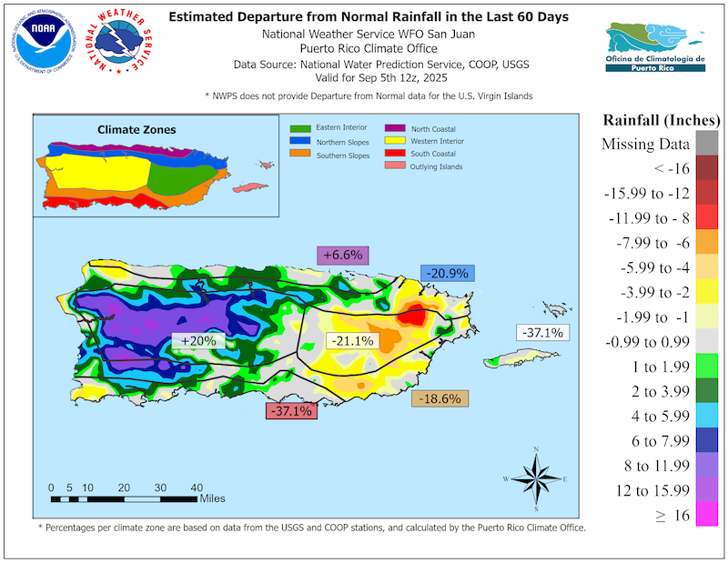
- Regional: The summer months were drier and hotter than normal across most of the U.S. Caribbean. The most significant event of the period was Hurricane Erin, which removed drought or dryness in St. Thomas, St. John, and all but the eastern portions of Puerto Rico. Though some rainfall also reached the eastern half of Puerto Rico, rainfall was below normal, resulting in dry soils and lower-than-normal streamflow.
- Puerto Rico Impacts: Drier and warmer than normal conditions in August led to cracked soils, dusty conditions, and crops impacts. By late August and September, rainfall increased across much of the island, but persistent dry conditions in the eastern interior and northeast continue to impact cacao, fruit trees, and irrigated vegetables, especially in the eastern interior and northeast.
- U.S. Virgin Islands (USVI) Impacts: St. John and St. Thomas reported mild flooding and heavy rain from Hurricane Erin, while St. Croix had little to no rain from the storm. Intermittent rain has not significantly improved groundwater levels, and there are ongoing signs of increased dryness across the territory. Sporadic rain is still occurring but not fully saturating the soil.
- Looking ahead: Wetter and warmer-than-normal conditions are expected to develop across Puerto Rico and the U.S. Virgin Islands through the rest of the fall and early winter months. However, the microclimates of the islands may still result in Abnormally Dry (D0) or drought conditions in some areas.
See below for additional details on current conditions, impacts (including streamflow and soil moisture), and outlooks.
U.S. Drought Monitor map for Puerto Rico and the U.S. Virgin Islands, as of September 9, 2025. The U.S. Drought Monitor is updated each Thursday to show the location and intensity of drought across the country.
The map uses 5 classifications: Abnormally Dry (D0), showing areas that may be going into or are coming out of drought, and four levels of drought (D1–D4).
A drought index combines multiple drought indicators (e.g., precipitation, temperature, soil moisture) to depict drought conditions. For some products, like the U.S. Drought Monitor, authors combine their analysis of drought indicators with input from local observers. Other drought indices, like the Standardized Precipitation Index (SPI), use an objective calculation to describe the severity, location, timing, and/or duration of drought.
Learn MorePeriods of drought can lead to inadequate water supply, threatening the health, safety, and welfare of communities. Streamflow, groundwater, reservoir, and snowpack data are key to monitoring and forecasting water supply.
Learn MoreDrought can reduce the water availability and water quality necessary for productive farms, ranches, and grazing lands, resulting in significant negative direct and indirect economic impacts to the agricultural sector. Monitoring agricultural drought typically focuses on examining levels of precipitation, evaporative demand, soil moisture, and surface/groundwater quantity and quality.
Learn MoreU.S. Drought Monitor
D0 - Abnormally Dry
Abnormally Dry (D0) indicates a region that is going into or coming out of drought, according to the U.S. Drought Monitor. View typical impacts by state.
D1 – Moderate Drought
Moderate Drought (D1) is the first of four drought categories (D1–D4), according to the U.S. Drought Monitor. View typical impacts by state.
D2 – Severe Drought
Severe Drought (D2) is the second of four drought categories (D1–D4), according to the U.S. Drought Monitor. View typical impacts by state.
D3 – Extreme Drought
Extreme Drought (D3) is the third of four drought categories (D1–D4), according to the U.S. Drought Monitor. View typical impacts by state.
D4 – Exceptional Drought
Exceptional Drought (D4) is the most intense drought category, according to the U.S. Drought Monitor. View typical impacts by state.
U.S. Drought Monitor map for Puerto Rico and the U.S. Virgin Islands, as of September 9, 2025. The U.S. Drought Monitor is updated each Thursday to show the location and intensity of drought across the country.
The map uses 5 classifications: Abnormally Dry (D0), showing areas that may be going into or are coming out of drought, and four levels of drought (D1–D4).
The U.S. Drought Monitor is updated weekly on Thursday morning, with data valid through that Tuesday at 7 a.m. ET.
A drought index combines multiple drought indicators (e.g., precipitation, temperature, soil moisture) to depict drought conditions. For some products, like the U.S. Drought Monitor, authors combine their analysis of drought indicators with input from local observers. Other drought indices, like the Standardized Precipitation Index (SPI), use an objective calculation to describe the severity, location, timing, and/or duration of drought.
Learn MorePeriods of drought can lead to inadequate water supply, threatening the health, safety, and welfare of communities. Streamflow, groundwater, reservoir, and snowpack data are key to monitoring and forecasting water supply.
Learn MoreDrought can reduce the water availability and water quality necessary for productive farms, ranches, and grazing lands, resulting in significant negative direct and indirect economic impacts to the agricultural sector. Monitoring agricultural drought typically focuses on examining levels of precipitation, evaporative demand, soil moisture, and surface/groundwater quantity and quality.
Learn MoreThis update is based on data available as of 5 p.m. AT on Tuesday, September 9, 2025. We acknowledge that conditions are evolving.
Current Drought and Climate Conditions
- According to the U.S. Drought Monitor, Abnormally Dry (D0) conditions are present in eastern Puerto Rico, with Moderate Drought (D1) on St. Croix. The remaining area is drought-free.
- Puerto Rico and the USVI experienced a drier- and warmer-than-normal summer.
- In Puerto Rico, below-normal precipitation, dry soils, and below-normal streamflow led to Abnormally Dry (D0) conditions along the northwest, southeast, and eastern interior.
- In July and early August, increasing well depth (i.e., less available groundwater) and a lack of significant rain resulted in the introduction of Moderate Drought (D1) across St. Croix and St. Thomas, and D0 conditions in St. John.
- The most significant event of the period was Hurricane Erin in August.
- Though the cyclone moved north of the region, heavy rain reached St. Thomas and St. John, as well as interior, west, and southern Puerto Rico.
- Rainfall accumulations ranged from 4 to 7 inches in under 48 hours. This heavy rainfall removed drought and dryness on St. Thomas and St. John. St. Croix did not receive as much rain, so Moderate Drought (D1) conditions persisted.
- While some rainfall also reached the eastern half of Puerto Rico, rainfall was still below normal, resulting in dry soils and lower-than-normal streamflow. Intermittent rain has not significantly improved groundwater levels for the USVI. To view U.S. Geological Survey (USGS) monitoring well levels, visit the USGS Virgin Islands water conditions page.
Puerto Rico’s Summer Was Wet in the West and Dry in the East
Impacts for Puerto Rico and the U.S. Virgin Islands
Agricultural Impacts
- Report your Impacts: To report the effects of dry conditions on your farm projects for future drought updates, use the Drought Condition Monitoring Observations and Reports (CMOR) tool or join the USDA Caribbean Climate Hub reporter group chat on WhatsApp.
- Puerto Rico:
- Central interior region (Aguas Buenas, Caguas, Barranquitas, Orocovis, Naranjito):
- Farmers in this region report variable and unpredictable conditions, with sporadic rains insufficient to improve soil moisture.
- Droughts dominated in August, leading to cracked soils, dusty conditions, and crops affected by lack of water. In particular, the cacao crop showed yellowing leaves and reduced yields. Young fruit trees still in bags and irrigated vegetables were also impacted.
- In Caguas, some farmers noted high temperatures in hydroponic systems caused heat-related losses. In the Aguas Buenas area, atypically dry conditions wilted the vegetation.
- Northern region (Barceloneta, Ciales, Manatí):
- Farmers report the rainy season began later than usual, but conditions are now favorable for crops.
- In recent weeks, significant rainfall has restored soil moisture and reduced the impact of extreme heat. Cacao trees began to sprout new growth, flower, and set fruit for the upcoming harvest.
- However, the humidity also accelerated weed growth.
- Northeast region (Canovanas, Fajardo):
- This region experienced several drier-than-normal months, with cracked soils on some farms.
- In recent weeks, the area experienced light and sporadic rains, but the rain remains neither consistent nor abundant.
- While the dryness makes farm maintenance easier due to the lack of mud, the absence of regular rainfall limits soil moisture recovery.
- East region (Las Piedras): This region reports constant rain for the past two weeks.
- Southern region (Coamo): Over the past two weeks, the region reports some heavy rainfall events followed by extremely hot days.
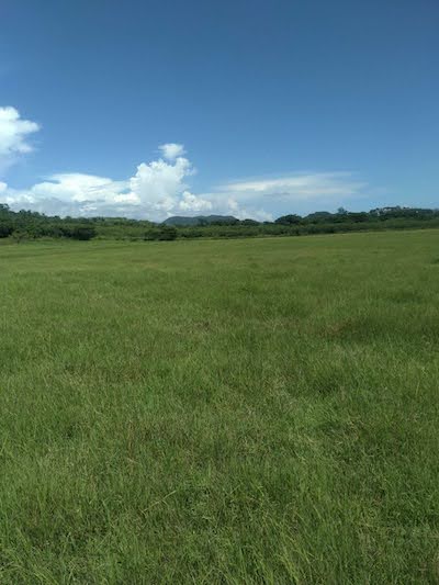
- Southwest region (Lajas): Farmers report extreme temperatures ranging from 90–104°F, along with considerable rainfall. These rains have helped restore pastures and improve soil moisture availability, although the intense heat persists.
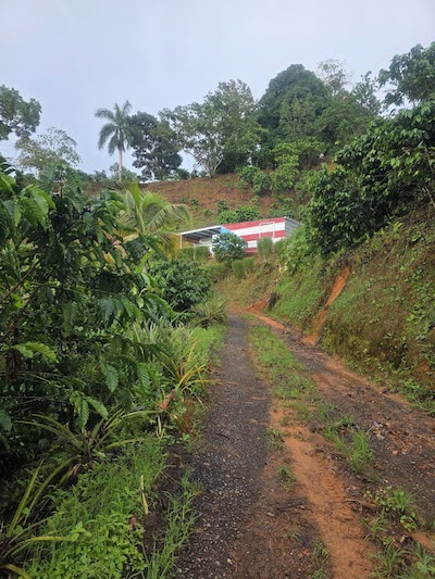
- Western region (Las Marías, Mayagüez, San Sebastián, Lares):
- In recent weeks, soils remained very moist, causing minor but controlled landslides in some farms, as well as accelerated weed growth.
- Ripening is delayed on coffee beans plantation. In previous years, harvests would begin in July, but this year, they were delayed to September.
- Farmers note increased rainfall compared to prior years. This benefited the weight of the coffee beans, but raises concerns about the proliferation of fungi and pests, especially in crops such as vanilla and cacao.
- Central interior region (Aguas Buenas, Caguas, Barranquitas, Orocovis, Naranjito):
- St. Thomas:
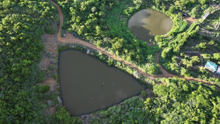
- Farmers in St. Thomas report ponds are full due to recent rains, and rain allowed vegetation to bounce back.
- Livestock and poultry farmers have access to feed. However, Guinea grass is still drying due to high winds.
- Soil conditions on farms are dry and hard, with farmers reporting that rain is not actually permeating the soil. Groundwater is not showing many gains after Hurricane Erin.
- St. John:
- St. John is experiencing intermittent rain and high winds.
- Row and specialty crop farmers report vegetation is bouncing back.
- Most are prepping land and planting specialty crops, microgreens, fruit trees, and quick crops to keep production up. They are also planning crop rotations when hotter summer months arrive later this year.
- Farmers are watching bananas for fungus issues.
- St. Croix:
- Many farmers are grateful for the intermittent rains. However, vegetation is still showing signs of lingering dryness. Livestock farmers are culling livestock and preparing for the fall planting of row and specialty crops.
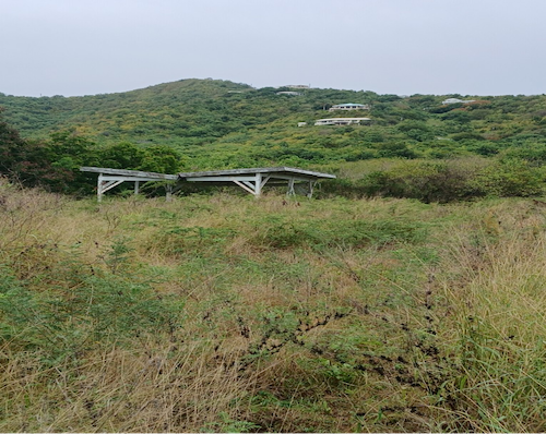
Pastures Are Recovering in Lajas, Puerto Rico
Weed Proliferation and Soil Erosion by Rain in Puerto Rico Coffee Farm
Ponds Are Full on St. Thomas Due to Recent Rains
No Signs of Dryness on St. John

Dry Vegetation on St. Croix
Puerto Rico Streamflow and Soil Moisture Impacts
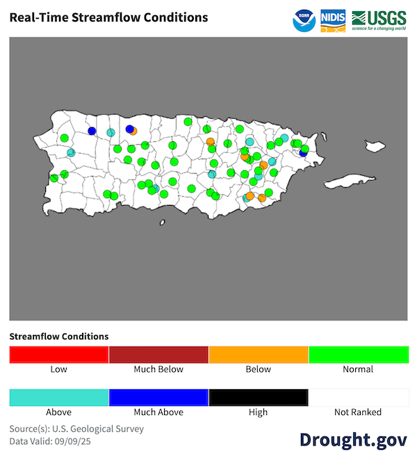
- Most rivers have near-normal to high streamflows across interior and western Puerto Rico. On the other hand, the lack of rain resulted in lower-than-normal flows along portions of the east interior and southeast Puerto Rico. Fortunately, these low flows have not adversely impacted the main water reservoirs in Puerto Rico.
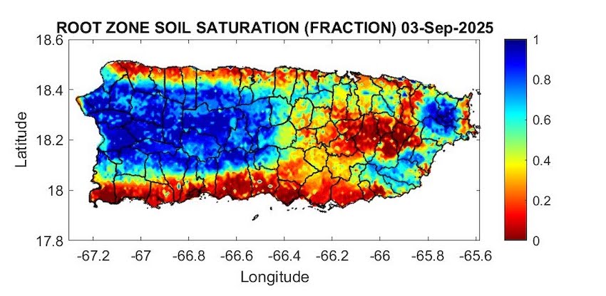
- Soils are saturated along the interior and west of Puerto Rico, and near El Yunque. In contrast, some locations of the eastern interior, the southern, and the northern plains exhibit dry soils.
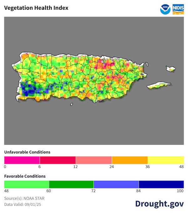
- Vegetation is healthy in most of the territory, although crop stress continues for Puerto Rico’s north and south coasts, and areas of the eastern interior between Comerío and Las Piedras.
Puerto Rico River Flow Levels Are Mostly Normal
Puerto Rico's Soils Are Wet in the West, and Dry in the Eastern Interior
Vegetation Health Varies Across Puerto Rico
Outlooks and Potential Impacts for Puerto Rico and the U.S. Virgin Islands
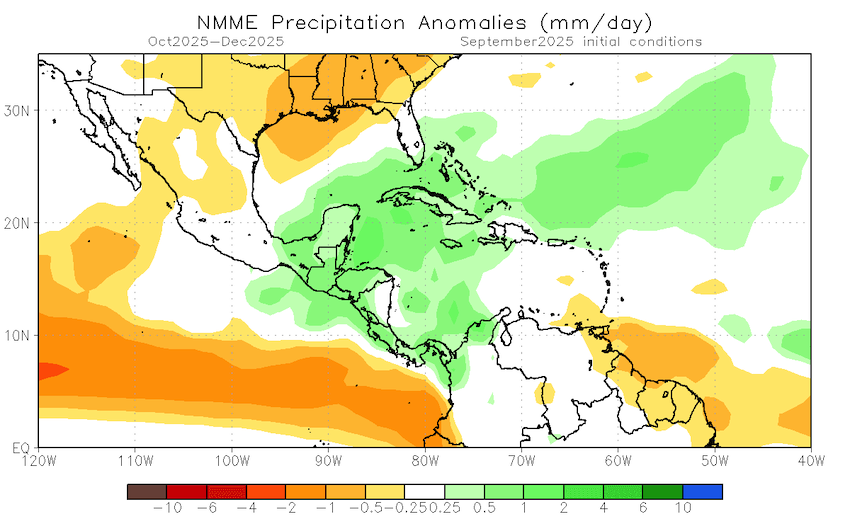
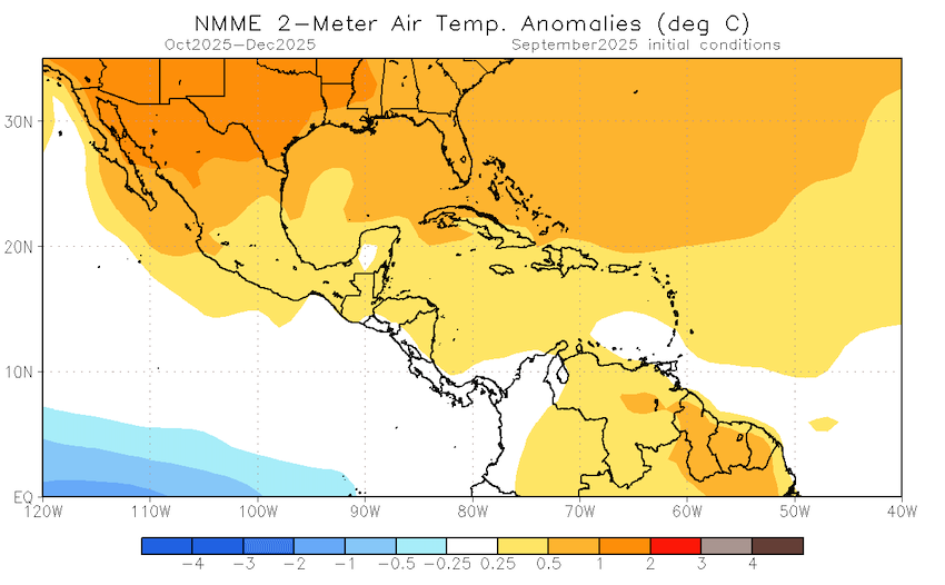
- The North American Multi-Model Ensemble for fall and early winter (October–December 2025) predicts slightly wetter-than-normal conditions for Puerto Rico and the Virgin Islands (~50% chance) and warmer than normal temperatures (>70% chance).
- Drought might develop over the next three months in portions of east-interior Puerto Rico, while Moderate Drought (D1) conditions may continue for Saint Croix in the U.S. Virgin Islands, according to the NOAA Climate Prediction Center’s current Seasonal Drought Outlook.
Fall and Early Winter Are Expected to Be Wet and Warm
Additional Resources
National Weather Service Weather Forecast Offices:
- San Juan Climate and Drought Information
- Puerto Rico and U.S. Virgin Islands Fire Weather Information
- National Weather Service Drought Information Statements
U.S. Drought Portal (Drought.gov):
USDA Caribbean Climate Hub: Drought and disaster assistance resources for tropical forestry and agriculture
Southeast Regional Climate Center: Quarterly Climate Impact and Outlook Reports (March 2025), which includes Puerto Rico and U.S. Virgin Islands.
Prepared By
Emanuel Rodríguez-González
NOAA National Weather Service Weather Forecast Office San Juan
William A. Gould, Nohely Reyes-Pérez
U.S. Department of Agriculture (USDA) Caribbean Climate Hub, USDA Forest Service Research and Development
Christina Chanes
University of the Virgin Islands
Meredith Muth
NOAA National Integrated Drought Information System (NIDIS)
Héctor J. Jiménez
University of Puerto Rico Office of Climatology
Elliot Sosa
U.S. Geological Survey Caribbean–Florida Water Science Center (CFWSC)
Brad Rippey
USDA Office of the Chief Economist
Puerto Rico Reporting Input:Thanks to Café Xiojana, Hacienda Terruño, Hacienda Chocolat, Finca Gonzalez, and De Mi Tierra A Mi Pueblo. Special thanks to agronomists, extension agents, researchers, volunteers, ranchers, and farmers: Jonathan González, Samuel Rodriguez, Silmarie Crespo-Velez, Diana Guzmán-Colón, Jorge Morales, Bernabe Martir, Manuel Candelaria, José Acosta, Harry Ramirez, Jorge Reyes Medina, and others.
USVI Reporting Input: Several individuals contributed to this report and we are acknowledging the following for their support including the farming community across the USVI, University of the Virgin Islands (UVI) faculty, staff, and collaborators of the UVI Department of Chemical and Physical Sciences, UVI Etelman Observatory, UVI Agricultural Experiment Station, Virgin Islands Department of Agriculture, as well as the U.S. Department of Agriculture (USDA) Office of the Chief Economist, National Parks Service in St. Croix and St. John, Virgin Islands Department of Planning and Natural Resources, USDA Farm Service Agency andNatural Resources Conservation Services in St Croix, Coral Bay Community Council; and the many volunteer drought reporters, volunteers, and farmers from across the territory.
About This Report
This drought update is issued in partnership between the National Integrated Drought Information System (NIDIS), National Oceanic and Atmospheric Administration (NOAA) National Weather Service, the U.S. Department of Agriculture (USDA), and the University of the Virgin Islands. The purpose of the update is to communicate a potential area of concern for drought expansion and/or development within Puerto Rico and the U.S. Virgin Islands based on recent conditions and the upcoming three-month forecast.
NIDIS and its partners will issue these updates every two months. Subscribe for these U.S. Caribbean drought updates here.
