Record-setting drought in Kansas and Oklahoma to persist through winter.
- Exceptional (D4) drought persists across southern Kansas (36% of the state) and Oklahoma (20%).
- Drought in the Southern Plains is expected to remain through winter.
- Best chance for significant drought relief will be in spring.
The U.S. Drought Monitor is updated each Thursday to show the location and intensity of drought across the country. Drought categories show experts’ assessments of conditions related to dryness and drought including observations of how much water is available in streams, lakes, and soils compared to usual for the same time of year.
This map shows drought conditions across the Southern Plains Drought Early Warning System as of December 6, 2022.
U.S. Drought Monitor Categories
Abnormally Dry (D0)
Abnormally Dry (D0) indicates a region that is going into or coming out of drought. View typical impacts by state.
Moderate Drought (D1)
Moderate Drought (D1) is the first of four drought categories (D1–D4), according to the U.S. Drought Monitor. View typical impacts by state.
Severe Drought (D2)
Severe Drought (D2) is the second of four drought categories (D1–D4), according to the U.S. Drought Monitor. View typical impacts by state.
Extreme Drought (D3)
Extreme Drought (D3) is the third of four drought categories (D1–D4), according to the U.S. Drought Monitor. View typical impacts by state.
Exceptional Drought (D4)
Exceptional Drought (D4) is the most intense drought category, according to the U.S. Drought Monitor. View typical impacts by state.
The U.S. Drought Monitor is updated each Thursday to show the location and intensity of drought across the country. Drought categories show experts’ assessments of conditions related to dryness and drought including observations of how much water is available in streams, lakes, and soils compared to usual for the same time of year.
This map shows drought conditions across the Southern Plains Drought Early Warning System as of December 6, 2022.
U.S. Drought Monitor
- 63% of the Southern Plains region is in drought (D1 or worse), according to the U.S. Drought Monitor.
- 25% of the region is experiencing extreme (D3) drought or worse.
- 10% of the region is experiencing exceptional (D4) drought.
- 35.9% of Kansas is now in D4 status. That's the highest percentage of exceptional drought (D4) since February 2013, and is currently the largest percentage of D4 of any U.S. state (Oklahoma is second at 20%).
- Extreme (D3) drought conditions have been in place in this region since August 2019.
- Moderate (D1) or worse drought has been in the region since June 2016.
Current Drought Conditions
- A record-setting drought has been crippling agriculture in western Kansas and parts of Oklahoma.
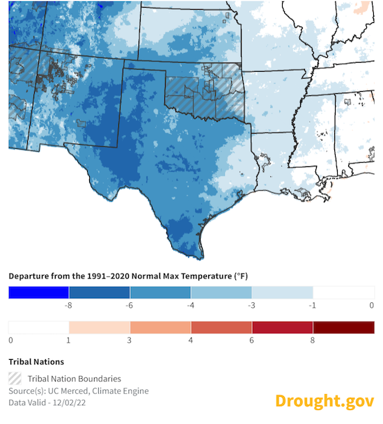
- November temperatures: Overall, November was cooler than average for the Southern Plains.
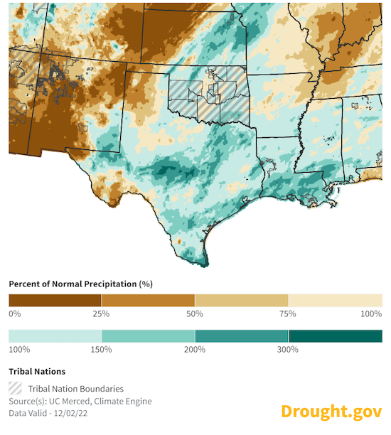
- November precipitation: While both Kansas and Oklahoma state-wide precipitation was near average to a little below average for November, it was not evenly distributed across the state, and parts of western Kansas had monthly rainfall in the lowest 5% of historical records.
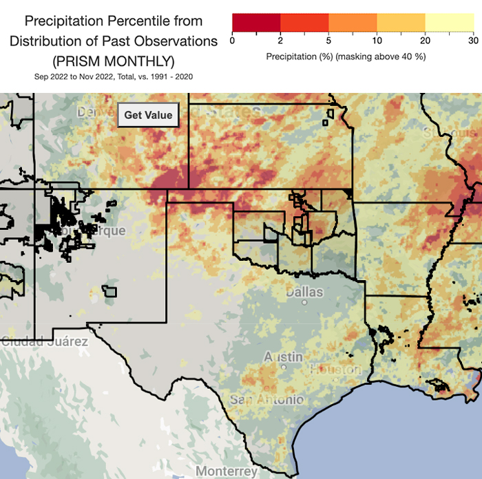
- Fall precipitation: Far-southwestern Kansas, parts of the Oklahoma and Texas Panhandles, and far-northeastern New Mexico (Union County) had fall precipitation in the lowest 5% of historical records with a few new low precipitation records set for the season.
30-Day Departure from Normal Maximum Temperature
30-Day Percent of Normal Precipitation
September–November 2022 Precipitation Percentiles
Southern Plains Drought in the News
- NPR: In the Great Plains, there's not much relief in sight from a historic drought
- KURC: Here's how this year's drought has battered the Midwest — and what it might mean for next year
- Newsweek: A Million Migrating Birds Expecting Kansas Wetlands Will Find Dust
- WIBW: Kansas Game Wardens warn that drought means coyotes may move into town
- Midwest Messenger: Cost to raise a cow could top $1K, according to Kansas economics professor
- Kansas Reflector: Santa, Christmas tree growers weigh in on Kansas climate during annual Christmas tradition
- KWCH: Historic drought leads Kansas cattle ranchers to sell herds
- KWCH: Slimming the herd: Kansas ranchers face difficult decisions due to drought
- KWCH: Unprecedented: Persistent drought heightens concerns for Kansas wheat farmers
- OU Daily: Local agricultural, livestock producers struggle with inflation, drought in central Oklahoma
- OSU Extension: Producers encouraged to mitigate risk, take advantage of drought relief
- KOCO News: Oklahoma farmers face hits from drought, economy this year
- OK Fox 12: Emergency Drought Commission approves additional $12M to drought cost-share program
- The Western Producer: U.S. winter wheat crop in trouble
How Will Drought Conditions Change Through Winter 2022?
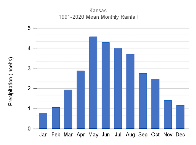
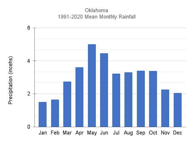
Winter Is Usually the Driest Time of Year for the Southern Plains
- December, January, and February are usually the driest months of the year for Kansas and Oklahoma.
- Even small amounts of precipitation will be beneficial for the winter wheat crop, but drought-busting storms are unlikely to happen until spring.
Kansas Monthly Average Precipitation
Oklahoma Monthly Average Precipitation
Forecasts and Seasonal Outlooks: December 2022
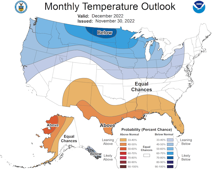
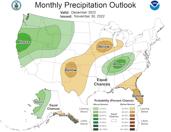
The Climate Prediction Center's monthly outlook for December shows:
- Temperature: December is likely to be warmer than normal for southern Texas and New Mexico. There is an equal chance of above- or below-normal temperatures for the rest of the Southern Plains.
- Precipitation: Odds slightly favor a dry December, with the highest odds over northeastern New Mexico.
December 2022 Temperature Outlook
December 2022 Precipitation Outlook
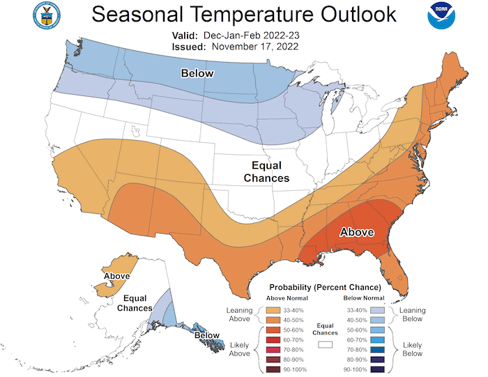
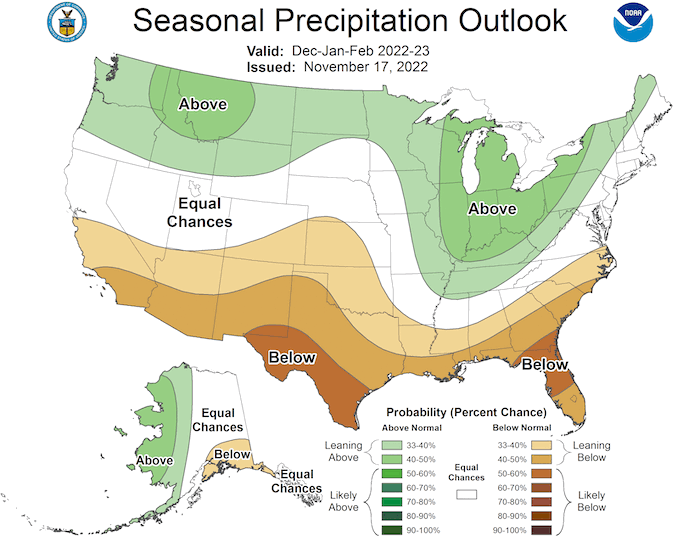
3-Month Outlook for December 2022–February 2023
Seasonal forecasts for winter (December–February) show a warmer and drier-than-normal season ahead for southern Texas and southern New Mexico. There are only weak odds favoring drier weather for the rest of the region.
Seasonal Temperature Outlook: December 2022–February 2023
Seasonal Precipitation Outlook: December 2022–February 2023
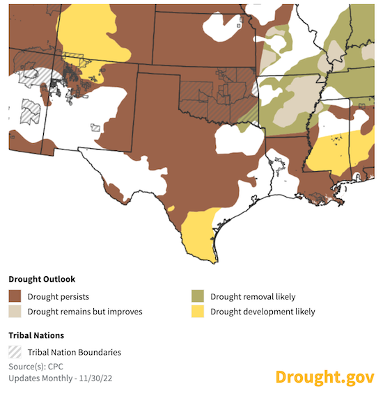
Seasonal Drought Outlook for December 2022—February 2023
With the seasonal outlooks strongly favoring below-normal precipitation for Texas and generally favoring below-normal precipitation for Oklahoma and Kansas, the Climate Prediction Center's seasonal drought outlook shows continued or returning drought for the region this winter.
3-Month U.S. Drought Outlook
State-Based Conditions and Impacts
Kansas
- November 2022 was in the top 10 driest Novembers on record for both northwestern and west-central Kansas. Combined with the previous month, October–November 2022 is the driest on record in west-central Kansas, where only 0.15 inch of precipitation has fallen.
- This was the driest July–November on record in south-central Kansas—and in the top 10 driest for southeastern, west-central, and southwestern Kansas.
- Precipitation deficits since April 1 range from 3.8 inches in east-central Kansas to 9.0 inches in west-central Kansas.
- Early November precipitation led to improvements in soil moisture and surface water in southeastern Kansas.
- Blowing dust and several wildfires occurred with several strong wind events.
- Winter wheat has seasonally gone dormant. Concerns exist with early cold on drought driven poor fall growth.
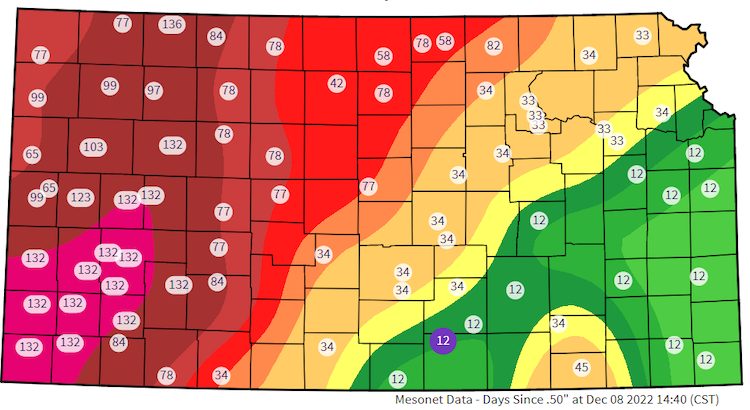
Consecutive Days Since 0.5" Single-Day Precipitation
Oklahoma
- Above-normal precipitation through November into early December helped ease drought conditions in southern and eastern Oklahoma.
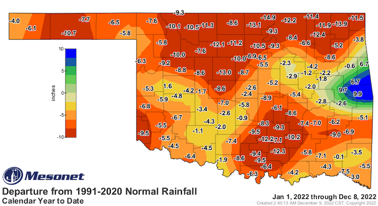
- Deficits remain significant on the 6-month and calendar year time scales, with widespread shortfalls of 5–15 inches.
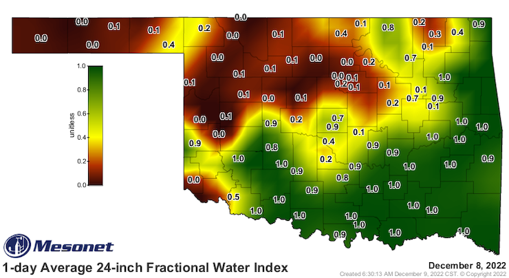
- Topsoil moisture has improved statewide, save for the western Panhandle where significant rains have stalled for the past couple of months.
- Subsoils remain dry, particularly across northern and western Oklahoma.
Departure from Normal Precipitation: 2022 YTD
1-Day Average 24-Inch Fractional Water Index
Texas
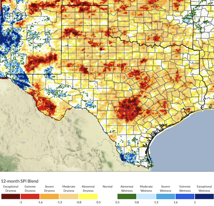
- While late November rain provided some relief to much of the state, portions of the Edwards Plateau and far-northern Panhandle continue to experience exceptional drought (D4) conditions.
- To reach average annual rainfall totals in the Edwards Plateau, more than 15 inches of rain would have to fall by the end December.
- The city of San Antonio had its third driest January to December in the 137-year period of record (3.7 inches less than in 2011).
- Throughout the state, ranchers continue to provide supplemental feeding for cattle.
- Cooling temperatures and beneficial rain that covered most of the state in late November allowed sufficient soil moisture for wheat and cool season crops to green up, but continued moisture is needed for fields to thrive.
- Increased soil moisture hindered pecan, cotton, and peanut harvests.
12-Month Standardized Precipitation Index (SPI) Blend
For More Information
- NIDIS and its partners will issue future drought status updates as conditions evolve.
- More local information is available from the following resources:
In Case You Missed It
- South Central U.S. Drought Update and Winter Outlook: November 14, 2022. Watch the recording here.
- Lower Mississippi River Basin Special Drought Webinar: November 18, 2022. Watch the recording here.
- Soil Moisture and Wildfire – Improving Fire Danger Rating Systems: November 16, 2022. Watch the recording here.
- Climate Engine Workshop and Training: November 9, 2022. Watch the recording here
Prepared By
Joel Lisonbee
NOAA’s National Integrated Drought Information System, Southern Plains Drought Early Warning System and CIRES/CU Boulder
Gary McManus
Oklahoma State Climatologist, Oklahoma Mesonet, Oklahoma Climatological Survey
Chip Redmond
Kansas Assistant State Climatologist, Kansas State University
John Nielsen-Gammon
Texas State Climatologist, Texas A&M University
Southern Regional Climate Center
Victor Murphy
National Weather Service
This drought status update is issued in partnership between the National Oceanic and Atmospheric Administration (NOAA) and the offices of the state climatologist for Texas, Oklahoma, New Mexico, and Kansas. The purpose of the update is to communicate a potential area of concern for drought expansion and/or development within the Southern Plains based on recent conditions and the upcoming forecast. NIDIS and its partners will issue future drought updates as conditions evolve.