Conditions are expected to improve after a summer of intense drought.
Key Points
- Recent rainfall will ameliorate but not remove drought conditions across the Southern Plains region.
- Long-range seasonal outlooks suggest drought is likely to continue through the fall.
- Larger rainfall totals are expected to return in the winter. A dry summer followed by a wet winter is typical when a strong El Niño pattern is in place.
The U.S. Drought Monitor depicts the location and intensity of drought across the country. The map uses 5 classifications: Abnormally Dry (D0), showing areas that may be going into or are coming out of drought, and four levels of drought (D1–D4).
The U.S. Drought Monitor is a joint effort of the National Oceanic and Atmospheric Administration, U.S. Department of Agriculture, and National Drought Mitigation Center.
U.S. Drought Monitor
D0 - Abnormally Dry
Abnormally Dry (D0) indicates a region that is going into or coming out of drought, according to the U.S. Drought Monitor. View typical impacts by state.
D1 – Moderate Drought
Moderate Drought (D1) is the first of four drought categories (D1–D4), according to the U.S. Drought Monitor. View typical impacts by state.
D2 – Severe Drought
Severe Drought (D2) is the second of four drought categories (D1–D4), according to the U.S. Drought Monitor. View typical impacts by state.
D3 – Extreme Drought
Extreme Drought (D3) is the third of four drought categories (D1–D4), according to the U.S. Drought Monitor. View typical impacts by state.
D4 – Exceptional Drought
Exceptional Drought (D4) is the most intense drought category, according to the U.S. Drought Monitor. View typical impacts by state.
The U.S. Drought Monitor depicts the location and intensity of drought across the country. The map uses 5 classifications: Abnormally Dry (D0), showing areas that may be going into or are coming out of drought, and four levels of drought (D1–D4).
The U.S. Drought Monitor is a joint effort of the National Oceanic and Atmospheric Administration, U.S. Department of Agriculture, and National Drought Mitigation Center.
This map is released every Thursday morning, with data valid through Tuesday at 7am Eastern.
Current Drought Conditions
U.S. Drought Monitor
- 76% of the region is in drought (D1 or worse), a 42% increase from 3 months ago.
- 33% of the region is experiencing Extreme (D3) drought or worse:
- Kansas—22% of the state
- New Mexico—31%
- Oklahoma—12%
- Texas—41%
- 10% of the region is experiencing Exceptional (D4) drought.
- Louisiana, while not in the Southern Plains DEWS region, has seen increasing drought. 99.9% of the state is in Moderate (D1) drought or worse, and 90% of the state in Extreme (D3) drought or worse.
- Extreme (D3) drought conditions have been in place in this region since August 2019.
- Moderate (D1) or worse drought has been in the region since June 2016.
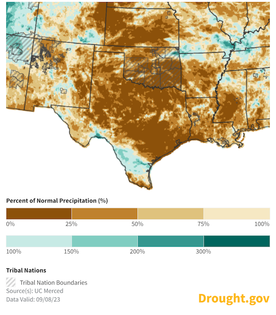
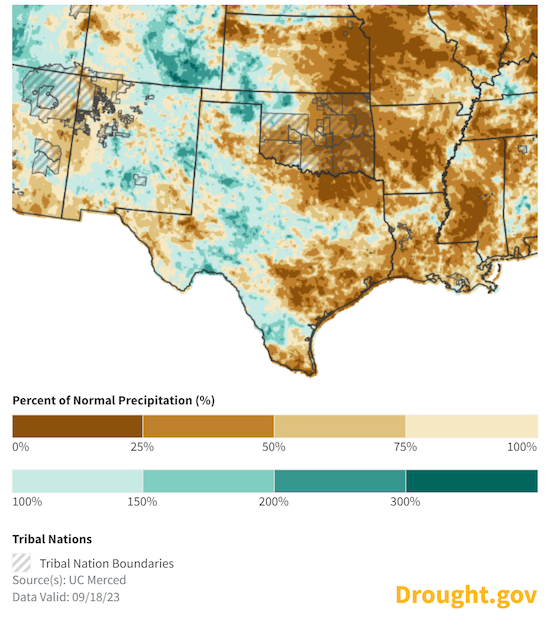
September Rainfall is Improving Drought in Parts of Texas
- A series of storms from the 11th through the 17th delivered over two inches of rain to many parts of western and central Texas, western Kansas, and the Oklahoma Panhandle.
- Eastern and Coastal Texas remain very dry.
30-Day Percent of Normal Precipitation: September 8 vs. September 18
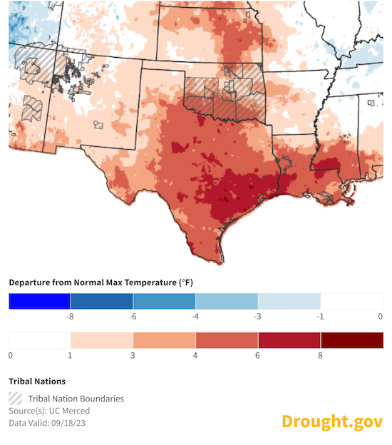
Recent Temperature Conditions
- Texas experienced its second highest August mean temperature and the 8th lowest August precipitation total on record. This makes August 2023 both the warmest and driest month on record in Texas since 2011.
- Over the last 30 days, temperatures across Texas and Louisiana were 4 to 8 ºF above average—and 3 ºF to 6 ºF above average for parts of Kansas and Oklahoma.
- On average, statewide, Texas usually receives 2.31 inches of rain in August and 2.93 inches of rain in September. This year the statewide average rainfall for August was only 0.96 inches, but rainfall was tracking near-normal through the first two-thirds of September.
- Persistently very high temperatures coupled with little to no rainfall over the summer has led to worsening drought conditions across central and southern Texas.
30-Day Departure from Normal Temperature Through September 18
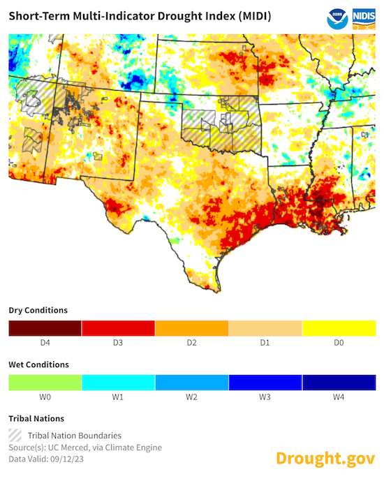
Short-Term Multi-Indicator Drought Index: September 12, 2023
Observed Drought Impacts
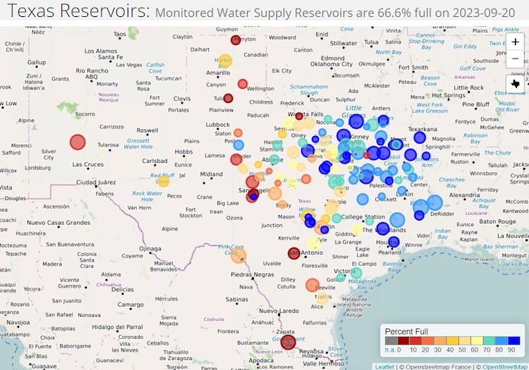
Texas Reservoir Storage
Water storage has decreased across the state, and reservoirs are now 66.6% full. This is more than 14% below the median value for this time of year, and 3.8% lower than at this time last year.
Texas Monitored Water Supply Reservoir Storage
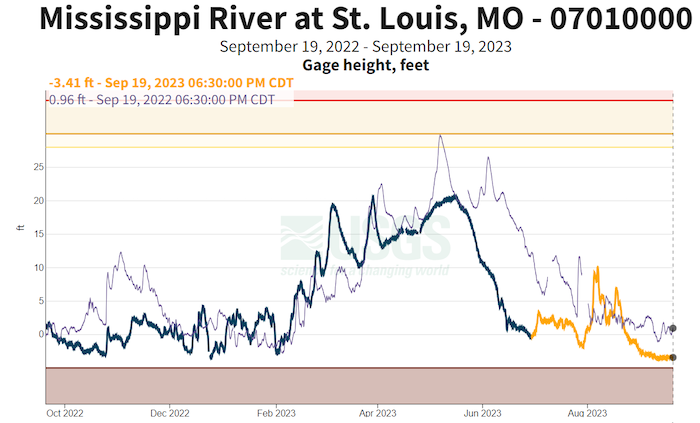
Mississippi River
The Mississippi River at St. Louis is lower than this time last year. September through November marks the climatological low point in Mississippi River flow annual flow.
Mississippi River Levels at St. Louis
Fire Conditions
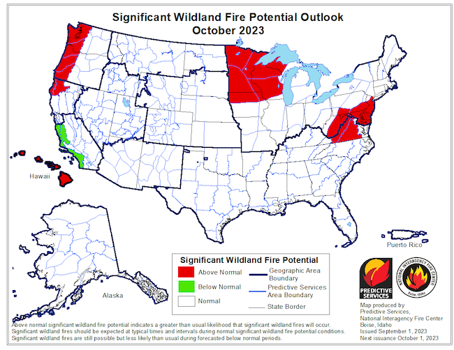
- After months of very hot, dry conditions, fuels remain dry, but cooler temperatures and recent rains in late August and early September did provide some help. In many regions, the Energy Release Component has improved from near-record to record values, though it is still near to above normal for the time of year across much of the region. With warm conditions in the forecast, areas that don’t receive rain over the next 1–2 weeks will likely see ERC values rise again.
- Wildland fire potential is expected to return to near-normal in October, per the National Interagency Coordination Center. Slightly above-normal wildfire activity may continue in some of the drier pockets around the region over the next few weeks.
October 2023 Wildland Fire Potential Outlook
Forecasts and Outlooks: When Will This Drought End?
Long-range seasonal outlooks suggest drought is likely to continue through the fall. Above-normal rainfall could return in the winter for portions of the region.
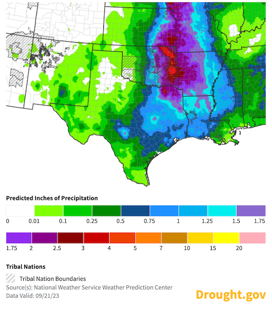
7-Day Precipitation Forecast: September 22–29
6–10 Day Precipitation Outlook: September 27–October 1
Forecasts and Seasonal Outlooks
According to the Climate Prediction Center's monthly outlook for October:
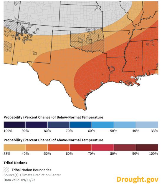
- Temperature: There are increased odds of above-normal temperatures in October for most of the Southern Plains, except for Kansas, where the odds are equal.
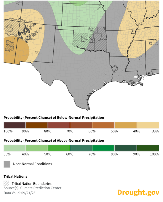
- Precipitation: The outlook shows an increased chance of above-normal precipitation for most of the Southern Plains in October. The chances for a wet month drop off near the Gulf Coast.
October 2023 Temperature Outlook
October 2023 Precipitation Outlook
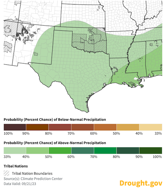
3-Month Outlook for October–December 2023
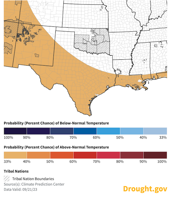
- The seasonal temperature outlook for October–December 2023 shows a warmer season ahead for southern Texas. There is a near-equal chance of above- or below-normal temperatures for the rest of the region.
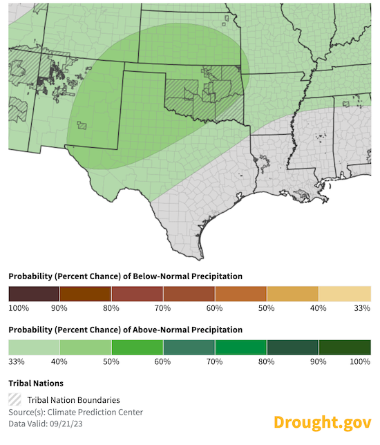
- The seasonal precipitation outlook for October–December 2023 calls for slightly increased odds for a wetter-than-normal season. This is typical for El Niño patterns in late fall and early winter.
October–December 2023 Temperature Outlook
October–December 2023 Precipitation Outlook
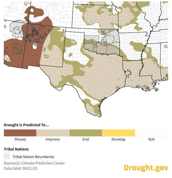
Seasonal Drought Outlook for October–December 2023
According to the latest U.S. Seasonal Drought Outlook, drought across the Southern Plains is forecast to remain but improve through the end of the year.
Long-Range Climate Guidance: Fall & Winter 2023
- El Niño conditions are present in the central Pacific and are anticipated to continue through the Northern Hemisphere winter.
- Each El Niño has impacted the Southern Plains weather differently, but on average, when a strong El Niño pattern is in place, the Southern Plains experiences a dry summer followed by a wet winter.
- El Niño was one factor in the extended drought conditions this summer. Past events indicate increased rainfall can be expected in late fall and early winter this year.
Risk of Precipitation Extremes During El Niño Years: July–September vs. October–December
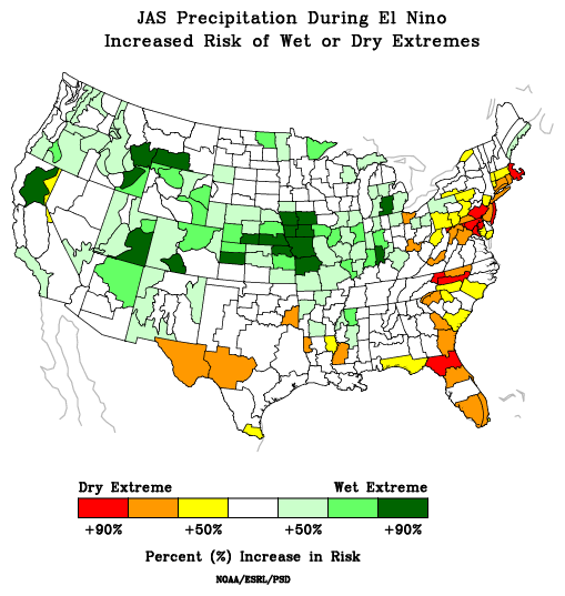
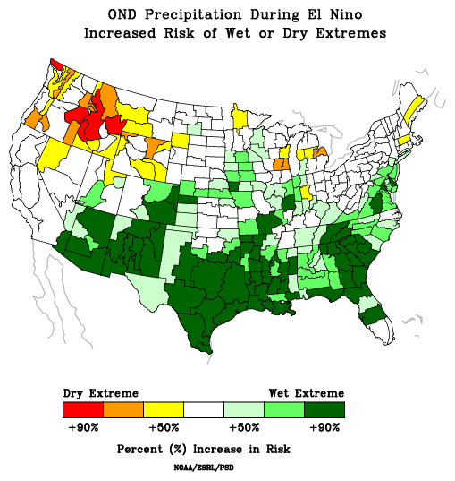
Source: NOAA's Physical Sciences Laboratory.
State-Based Conditions and Impacts
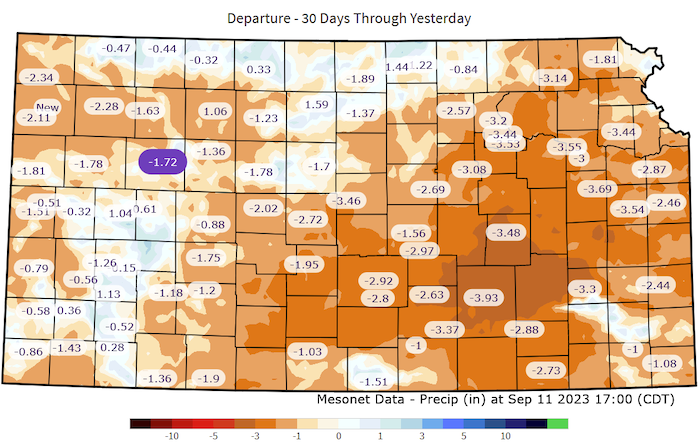
Kansas
- Early harvest is ongoing with rapid crop drying and maturing, making yields a great concern.
- Water supply demand is increasing in the east with water use restrictions in place in some Flint Hills communities.
- Reservoirs in eastern and central Kansas never rebounded this spring and fall. They are going into the dry season at below normal capacity.
30-Day Departure from Normal Precipitation
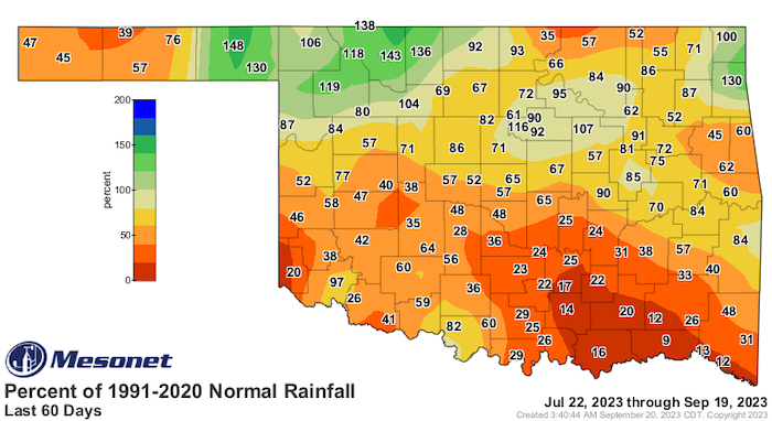
Oklahoma
- Flash drought is a concern in Oklahoma for the third time in the last three years with rapid intensification occurring across the southwestern half of the state. The dry period stretches out past 60 days.
- In addition to the short-term areas of flash drought, long-term drought continues to plague parts of north central and southwest Oklahoma, with deficits in those areas stretching back to late summer 2021.
- Dry soils are of particular concern to Oklahoma’s winter wheat growers this time of year as they consider planting this year’s crop for grazing by livestock later this winter. The USDA’s National Agricultural Statistics Service shows 72% of Oklahoma topsoil with short to very-short moisture conditions for the week ending Sept. 17, 2023.
60-Day Percent of Normal Precipitation
Texas
- Over the past month, beneficial rainfall amounts of 2–4 inches, with localized amounts of 5+ inches, fell across significant portions of the state. This includes south Texas (much of which came with Tropical Storm Harold on August 22), southeast Texas, the Rio Grande Plains, the Edwards Plateau and northern Hill Country, and the central and southern Panhandle.
- Lower rainfall amounts of mainly 0.5–2 inches fell across the western Trans-Pecos, the San Antonio area and southern Hill Country east into the inland Coastal Plains, and much of northeast Texas. Amounts lower than 0.5 inches in the past month were observed near the Red River north of Dallas and the Rio Grande northwest of the Big Bend.
- In north-central Texas, Belton Reservoir and Stillhouse Hollow Reservoir are both below 60% capacity for the first time since they were filled in the 1960s and 1970s.
Southern Plains Drought in the News
- KSAT: Hay prices rising, supply limited amid drought and extreme weather
- San Antonio Report: As Medina Lake disappears, local residents push for management changes
- KXAN: Georgetown finds new water source, but relief is years away
- MySA: Kyle calls on San Marcos for water to combat intense Texas drought
- 12NewsNow (Beaumont TX): 'Pretty brutal' | Wildfires taking a toll on Southeast Texas volunteer firefighters
- Killeen Daily Herald: Crashing down: Drought-, freeze-stressed trees are dropping limbs all over Texas
- 12NewsNow: Drought, water issues triggers disaster declaration in City of Beaumont
- My High Plains (Amarillo, TX): Texas drought sees first improvement in weeks after hottest, driest August in 12 years
- The Eagle: Temperamental post oaks don’t handle drought well
- CBS7: Midland County named the driest county in the Permian Basin
- Dallas Express: Video – Drought Reveals New Dinosaur Tracks
- WFAA: Texas drought conditions leading to rise in beef prices
- Fox Houston: Lake Livingston dried up sections reveal chunks of debris from deadly 2020 tornado
For More Information
- NIDIS and its partners will issue future drought status updates as conditions evolve.
- More local information is available from the following resources:
Prepared By
Joel Lisonbee,
NOAA’s National Integrated Drought Information System, Southern Plains Drought Early Warning System; CIRES/CU Boulder
Adam Lang and Eleanor Hasenbeck
NOAA’s National Integrated Drought Information System, Communications; CIRES/CU Boulder
Gary McManus
Oklahoma State Climatologist, Oklahoma Mesonet, Oklahoma Climatological Survey
Matt Sittel
Kansas Assistant State Climatologist, Kansas State University
John Nielsen-Gammon
Texas State Climatologist, Texas State Climate Office, Texas A&M University
Southern Regional Climate Center
William (BJ) Baule and Alison Tarter
Texas State Climate Office, Texas A&M University
Southern Regional Climate Center
Keith White and Victor Murphy
National Weather Service
This drought status update is issued in partnership between the National Oceanic and Atmospheric Administration (NOAA) and the offices of the state climatologist for Texas, Oklahoma, New Mexico, and Kansas. The purpose of the update is to communicate a potential area of concern for drought expansion and/or development within the Southern Plains based on recent conditions and the upcoming forecast. NIDIS and its partners will issue future drought updates as conditions evolve.
