A Soggy End to October + El Niño Winter: Drought Is Expected to Improve, but Remain
Key Points
- Oklahoma flash drought conditions ease after wet week in late October.
- Tropical moisture and heavy rains in late October are likely to improve short-term drought across the region.
- Long-term drought is expected to see continued improvement over the next three months.
The U.S. Drought Monitor depicts the location and intensity of drought across the country. The map uses 5 classifications: Abnormally Dry (D0), showing areas that may be going into or are coming out of drought, and four levels of drought (D1–D4).
The U.S. Drought Monitor is a joint effort of the National Oceanic and Atmospheric Administration, U.S. Department of Agriculture, and National Drought Mitigation Center.
U.S. Drought Monitor
D0 - Abnormally Dry
Abnormally Dry (D0) indicates a region that is going into or coming out of drought, according to the U.S. Drought Monitor. View typical impacts by state.
D1 – Moderate Drought
Moderate Drought (D1) is the first of four drought categories (D1–D4), according to the U.S. Drought Monitor. View typical impacts by state.
D2 – Severe Drought
Severe Drought (D2) is the second of four drought categories (D1–D4), according to the U.S. Drought Monitor. View typical impacts by state.
D3 – Extreme Drought
Extreme Drought (D3) is the third of four drought categories (D1–D4), according to the U.S. Drought Monitor. View typical impacts by state.
D4 – Exceptional Drought
Exceptional Drought (D4) is the most intense drought category, according to the U.S. Drought Monitor. View typical impacts by state.
The U.S. Drought Monitor depicts the location and intensity of drought across the country. The map uses 5 classifications: Abnormally Dry (D0), showing areas that may be going into or are coming out of drought, and four levels of drought (D1–D4).
The U.S. Drought Monitor is a joint effort of the National Oceanic and Atmospheric Administration, U.S. Department of Agriculture, and National Drought Mitigation Center.
This map is released every Thursday morning, with data valid through Tuesday at 7am Eastern.
What Are Current Drought Conditions in the Southern Plains?
U.S. Drought Monitor
- 72% of the region is in drought (D1 or worse), a 27% increase from 3 months ago.
- 25% of the region is experiencing Extreme (D3) drought or worse:
- Kansas—20% of the state
- New Mexico—37%
- Oklahoma—13%
- Texas—25%
- 5% of the region is experiencing Exceptional (D4) drought.
- Louisiana, while not in the Southern Plains DEWS region, has seen increasing drought. 99.9% of the state is in Moderate (D1) drought or worse, 88.5% of the state in Extreme (D3) drought or worse, and 67.62% of the state is in Exceptional (D4) drought, a new record high for the state.
- Extreme (D3) drought conditions have been in place in this region since August 2019.
- Moderate (D1) or worse drought has been in the region since June 2016.
Antecedent Rainfall, Temperatures, and Evaporation
- On average, statewide, Texas usually receives a bit over three inches of rain in September. A series of storms from September 11–17 delivered over two inches of rain to many parts of western and central Texas, western Kansas, and the Oklahoma Panhandle, which had been in extreme drought (D3). This provided some amelioration to drought in the region.
- October precipitation included some storms early in the month and a soggy week toward the end of the month (with mostly tropical moisture from remnants of Hurricane Norma), with a long dry spell in between.
- On average, Texas usually gets about 2.8 inches of rain in October, Oklahoma usually gets about 3.3 inches and the Kansas state-wide average is near 2.3 inches of rain.
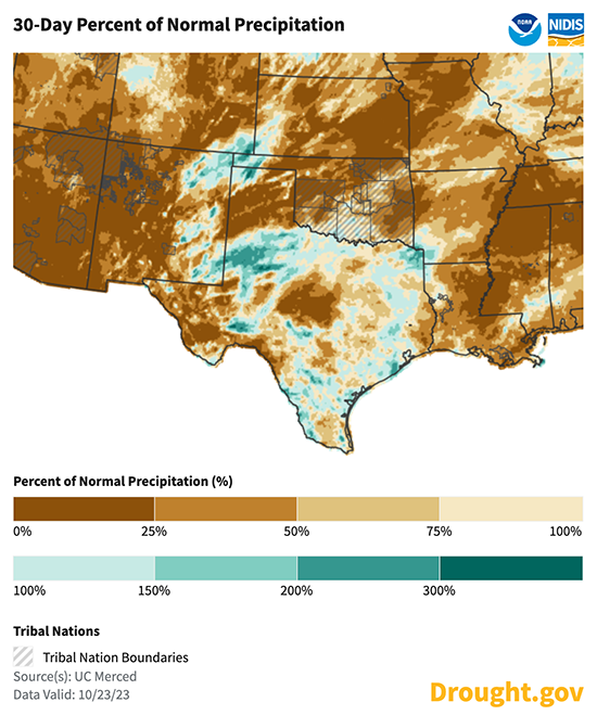
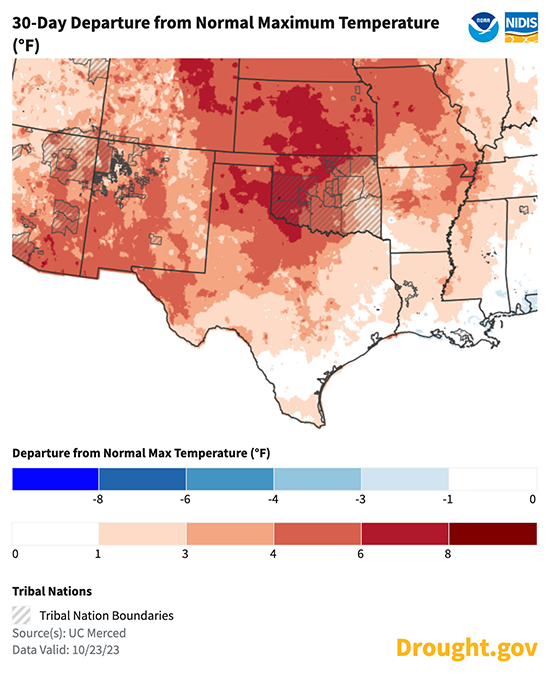
- Over the last 30 days, temperatures across the Southern Plains have been 1–6 ºF above normal. Precipitation has been generally low for most of the Southern Plains.
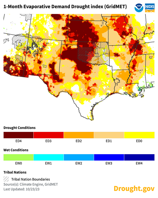
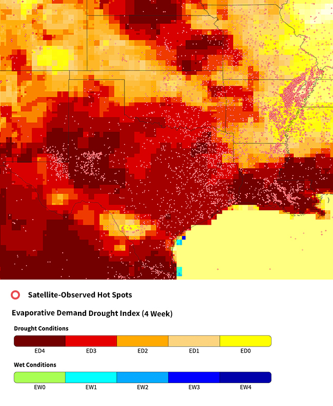
- Persistently high temperatures coupled with little to no rainfall have led to high evaporative demand and worsening drought conditions across northern, central, and western Texas.
Last 30 Days: Precipitation and Temperature Conditions
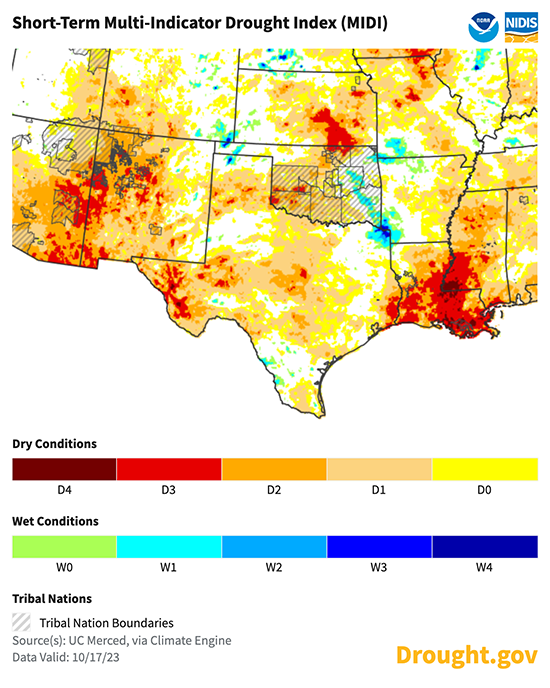
Short-Term Multi-Indicator Drought Index (MIDI)
1-Month Evaporative Demand Drought Index (EDDI)
Forecasts and Seasonal Outlooks: When Will This Drought End?
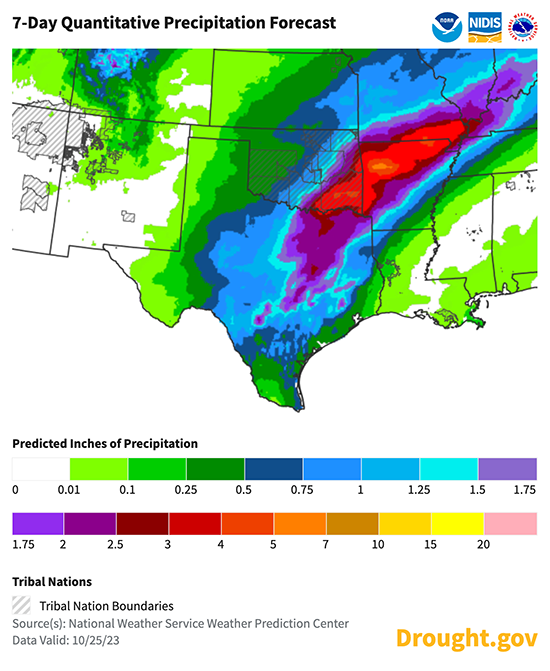
- The week ahead shows a continuation of wet weather. Moderate-to-heavy rainfall is forecast for drought-affected parts of central Texas, Oklahoma, and Kansas through the end of October.
- Heavy rainfall will likely all be west and north of Louisiana, where Exceptional (D4) drought is expected to continue through the next month or more.
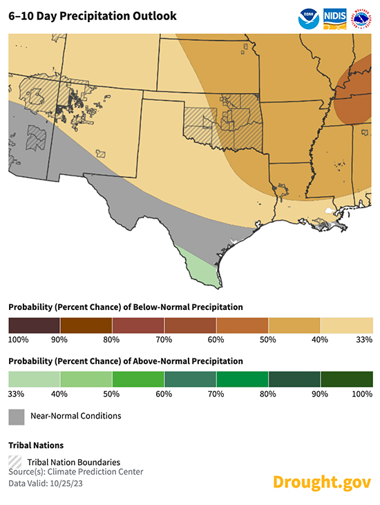
- The Climate Prediction Center's 6–10 day outlook shows slightly higher odds toward below-average precipitation through early November.
7-Day Precipitation Forecast: October 25–31
6–10 Day Precipitation Outlook: October 31–November 4
November 2023 Outlooks
According to the Climate Prediction Center's monthly outlook for November:
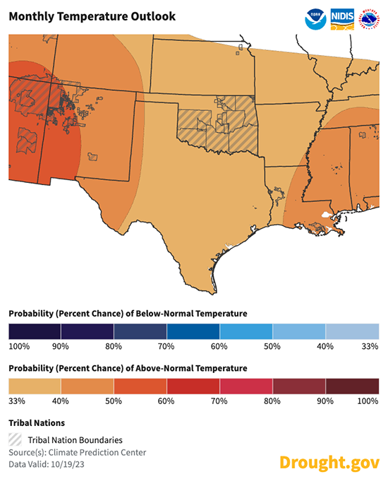
- Temperature: There are increased odds of above-normal temperatures in November for most of the Southern Plains.
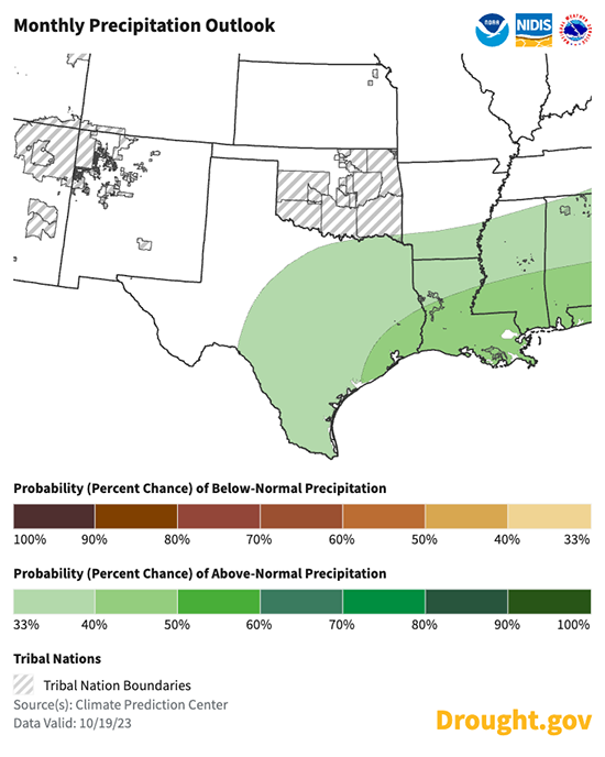
- Precipitation: The outlook shows an increased chance of above-normal precipitation for most of the Gulf Coast region in November. This would bring welcome drought relief to eastern Texas and Louisiana.
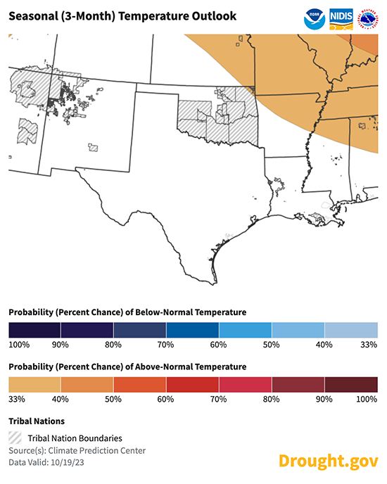
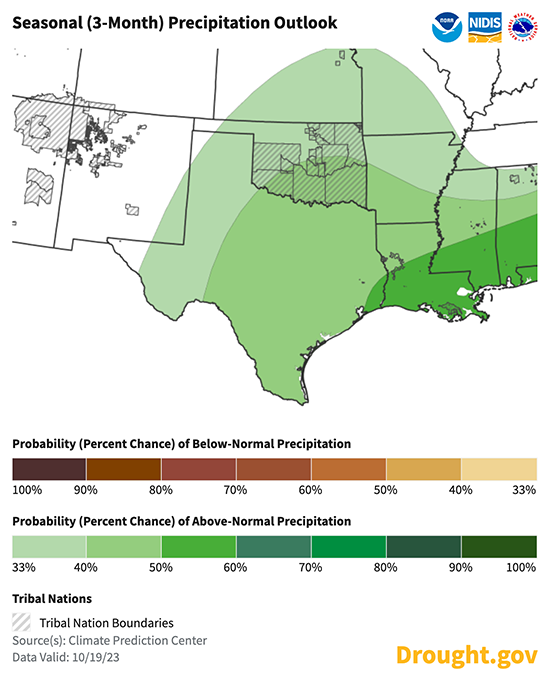
3-Month Outlook for November 2023–January 2024
- The Climate Prediction Center's seasonal temperature outlook for November 2023–January 2024 shows an equal chance of above- or below-normal temperatures for the Southern Plains.
- The seasonal precipitation outlook for November 2023–January 2024 calls for slightly increased odds for a wetter-than-normal season. The highest odds are along the Gulf Coast beginning in far eastern Texas. This is typical for El Niño patterns in late fall and early winter.
Long-Range Climate Guidance: Winter 2023
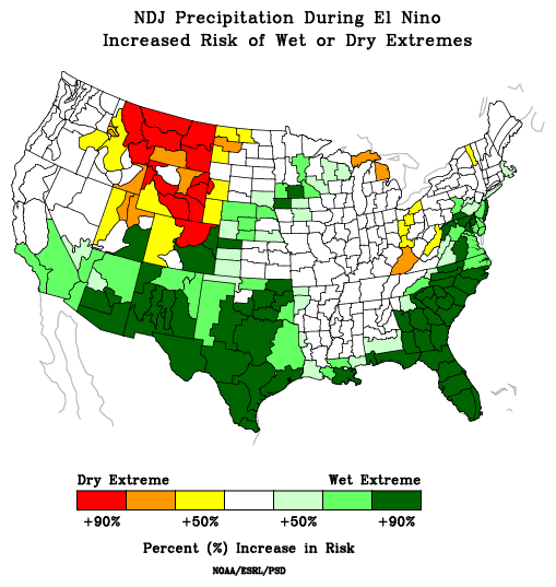
- El Niño conditions are present in the central Pacific and are anticipated to continue through the Northern Hemisphere winter.
- Each El Niño has impacted the Southern Plains weather differently, but on average, when a strong El Niño pattern is in place, the Southern Plains experiences a dry summer followed by a wet winter. El Niño was one factor in the extended drought conditions this summer. Past events indicate increased rainfall can be expected in late fall and early winter this year.
Risk of Precipitation Extremes During El Niño Years: November–January
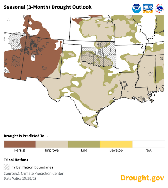
Seasonal Drought Outlook for October 17, 2023–January 31, 2024
- Drought is expected to improve over the next three months, according to the latest U.S. Drought Seasonal Outlook.
- This is supported by a wet seasonal outlook and the typical impact of El Niño on winter precipitation.
How Has Drought Impacted the Southern Plains?
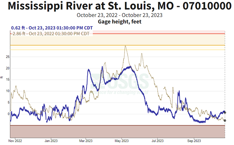
Mississippi River
- The Mississippi River at St. Louis reached a seasonal low in mid-September, exceeding low river levels from the year before.
- The river levels have risen slightly since reaching the seasonal low.
- Low flow through the Mississippi River has been creating problems for water supply and saltwater intrusion near New Orleans.
Mississippi River Levels at St. Louis
Fire Conditions
- After months of very hot, dry conditions, fuels remain dry through eastern Texas, and across Arkansas and Louisiana.
- The Tiger Island Fire, in Beauregard Parish, Louisiana, began on August 22 and burned over 31,000 acres, making it the largest fire in Louisiana state history.
- For Louisiana and Mississippi, summer 2023 was the most active fire season in each state's history.
- Smoke from fires, combined with fog, contributed to a major car accident north of New Orleans.
- Wildland fire potential is expected to return to near-normal through winter per the National Interagency Coordination Center. Slightly above-normal wildfire activity may continue in some of the drier pockets around the region over the next few weeks.
Fire Activity and Evaporative Demand
State-Based Conditions and Impacts
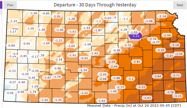
Kansas
- There has been little change to drought conditions. Nearly one-quarter of Kansas Mesonet sites, mostly in the eastern third of the state, are running at least 10 inches below normal precipitation for the year to date.
- Much-below-normal streamflow continues at many locations in the eastern half of the state.
- Soil moisture at the 5 cm level is lacking across the entire state.
30-Day Departure from Normal Precipitation
Oklahoma
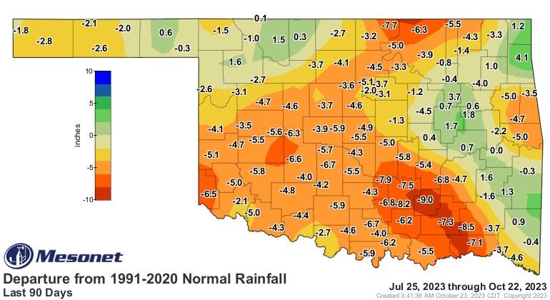
- Flash drought in Oklahoma extended more than 90 days before rains halted its advance.
- The extent of the flash drought was evident with widespread 90-day deficits of 4–8 inches.
- Long-term drought conditions stretching back to August 2021 continued in far southwest and north-central Oklahoma.
90-Day Departure from Normal Precipitation
Texas
- Over the past month, the majority of the state has seen continued below-normal rainfall. In some areas, like much of the northern Panhandle, northern Edwards Plateau, and Trans-Pecos, rainfall amounts were generally less than 0.5 inch.
- Even for many of the areas across much of northern and eastern Texas that received 1–3 inches of rain over the past month, these amounts were below average during what is typically one of the wetter months of the year in portions of the region.
- The main locations that received above-normal rainfall during this period include much of the area between Midland and Lubbock in west Texas, far northeastern Texas, and much of south Texas, and a few swaths across parts of Pecos, northern Terrell, and much of Kimble and Brazoria counties. Some other small swaths of above-normal rainfall were observed, but much larger portions of the state experienced drier conditions.
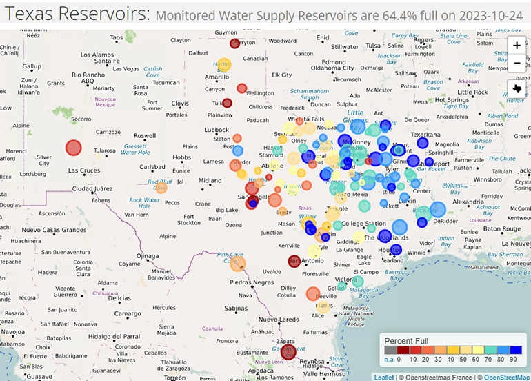
- Water storage continues to decrease across the state, and reservoirs are now 64.4% full. This is nearly 15% below the median value for this time of year, and 2.8% lower than at this time last year.
- On a more localized basis, the situation is even worse. Reservoir levels in the Edwards Plateau, south-central Texas, and along the Rio Grande remain at or near all-time lows for this time of year.
- Streamflows are similarly at or near all-time lows for this time of year across these regions.
Texas Reservoir Storage
Southern Plains Drought in the News
- KARK: Arkansas Storm Team Weather Blog: Drought worsens to severe levels
- NBC News: New Orleans braces for drinking water emergency from drought-stricken Mississippi River
- NPR: Louisiana citrus farmers are seeing a mass influx of salt water that could threaten seedlings
- High Plains Journal: Drought top story in southern Plains
- CNN: An El Niño winter is coming. Here’s what that could mean for the US
- Fox Weather: Heavy rain to bring some much needed drought relief to southern Plains
- Nola: When will rainfall drive back salt water in the Mississippi River? It's a guessing game.
- The Texas Tribune: Texas drought has deepened amid this year’s brutal heat
- KERA News: Drought causes North Texas ranchers to reduce herds, driving meat prices up
- AgriLife Today: Texas pumpkin yields hurt by heat and drought
- 5 NBC DFW: See before/after as exceptional drought conditions worsen across DFW
- News9: Drought Conditions In Kansas, Oklahoma Some Of Worst In Country
- Stillwater News Press: Flash Drought Surges During September
- 101.3 KFDI: Drought Continues for Much of Kansas
For More Information
- NIDIS and its partners will issue future drought status updates as conditions evolve.
- More local information is available from the following resources:
Prepared By
Joel Lisonbee, Adam Lang, Kelsey Satalino, and Eleanor Hasenbeck
NOAA’s National Integrated Drought Information System, CIRES/CU Boulder
Gary McManus
Oklahoma State Climatologist, Oklahoma Mesonet, Oklahoma Climatological Survey
Matt Sittel
Kansas Assistant State Climatologist, Kansas State University
John Nielsen-Gammon
Texas State Climatologist, Texas State Climate Office, Texas A&M University
Southern Regional Climate Center
William (BJ) Baule and Alison Tarter
Texas State Climate Office, Texas A&M University
Southern Regional Climate Center
Keith White and Victor Murphy
National Weather Service
This drought status update is issued in partnership between the National Oceanic and Atmospheric Administration (NOAA) and the offices of the state climatologist for Texas, Oklahoma, New Mexico, and Kansas. The purpose of the update is to communicate a potential area of concern for drought expansion and/or development within the Southern Plains based on recent conditions and the upcoming forecast. NIDIS and its partners will issue future drought updates as conditions evolve.
