Will the August rain wash away the Southern Plains drought?
Key Points
- Extreme rainfall and floods make a dent in drought in northeast Texas.
- Severe (D3) to exceptional (D4) drought remains in central Texas, Oklahoma, and western Kansas.
- Extreme heat and prolonged heat waves amplified, and in some cases rapidly intensified, drought in Oklahoma and Texas in July and early August.
- Despite the climate outlook slightly favoring a warm and dry season, drought in the Southern Plains is expected to improve, but remain through the fall.
The U.S. Drought Monitor is updated each Thursday to show the location and intensity of drought across the country. Drought categories show experts’ assessments of conditions related to dryness and drought including observations of how much water is available in streams, lakes, and soils compared to usual for the same time of year.
This map shows drought conditions across the Southern Plains Drought Early Warning System as of August 23, 2022.
U.S. Drought Monitor Categories
Abnormally Dry (D0)
Abnormally Dry (D0) indicates a region that is going into or coming out of drought. View typical impacts by state.
Moderate Drought (D1)
Moderate Drought (D1) is the first of four drought categories (D1–D4), according to the U.S. Drought Monitor. View typical impacts by state.
Severe Drought (D2)
Severe Drought (D2) is the second of four drought categories (D1–D4), according to the U.S. Drought Monitor. View typical impacts by state.
Extreme Drought (D3)
Extreme Drought (D3) is the third of four drought categories (D1–D4), according to the U.S. Drought Monitor. View typical impacts by state.
Exceptional Drought (D4)
Exceptional Drought (D4) is the most intense drought category, according to the U.S. Drought Monitor. View typical impacts by state.
The U.S. Drought Monitor is updated each Thursday to show the location and intensity of drought across the country. Drought categories show experts’ assessments of conditions related to dryness and drought including observations of how much water is available in streams, lakes, and soils compared to usual for the same time of year.
This map shows drought conditions across the Southern Plains Drought Early Warning System as of August 23, 2022.
Current Drought Conditions and Outlook
Extreme Rainfall Dents Drought in Texas
- The Dallas-Fort Worth metroplex experienced flooding on August 21–22 when over 9 inches of rain fell within about 24 hours.
- The highest total was a rain gauge on White Rock Creek in Dallas tallied 15.16 inches.
- DFW Airport accumulated 9.19 inches, which is the 2nd highest 24-hour total on record for the airport. (The record is 9.57 inches on September 4–5, 1932.)
- After measuring only a trace of rain through most of June and all of July, DFW Airport has accumulated 10.38 inches in August 2022 setting a new record high August rainfall total (the previous record was August 1915 with 10.33 inches).
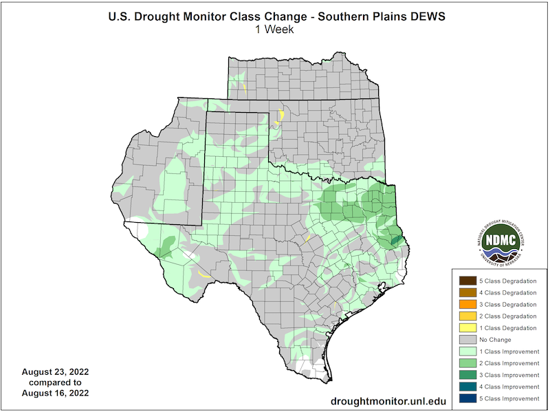
- In the 12 months from August 17, 2021–August 16, 2022 the Dallas region experienced a roughly 15-inch rainfall deficit and was in extreme to exceptional drought according to the August 16 U.S. Drought Monitor. Dallas and much of northeast Texas experienced a two-class drought improvement according to the August 23 U.S. Drought Monitor.
U.S. Drought Monitor Conditions
- 91.5% of the region is in drought (D1 or worse).
- 41% of the region is experiencing Extreme (D3) drought or worse.
- Extreme (D3) drought conditions have been in place in this region since August 2019.
- Moderate (D1) or worse drought has been in the region since June 2016
U.S. Drought Monitor 1-Week Change Map
Drought and Heat July through mid-August
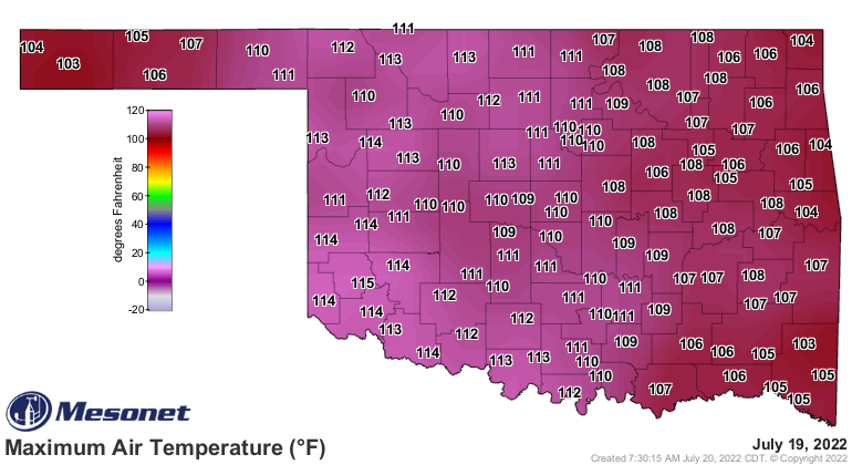
- This was the hottest July on record for Texas:
- The monthly mean daily maximum temperature was 5.8 ºF above the long-term average and highest on record.
- This was the first time on record that the state-averaged July mean daily maximum temperature exceeded 100 ºF.
- This was the second time on record that the state-averaged mean daily maximum temperature for any month exceeded 100 ºF (the other time was August 2011 when the statewide mean daily maximum temperature was 101.6 ºF)
- The monthly mean temperature was 5.0 ºF above the long-term average and the highest on record.
- The monthly mean daily minimum temperature was 4.0 ºF above the long-term average and the highest on record.
- The monthly mean daily maximum temperature was 5.8 ºF above the long-term average and highest on record.
- This was the 5th driest July on record for Texas and the driest July since 2011.
- This was the 5th hottest July on record for Oklahoma.
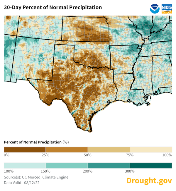
30-Day Percent of Normal Precipitation
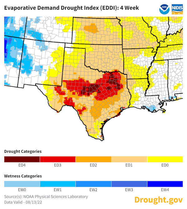
4-Week Evaporative Demand Drought Index (EDDI)
Forecasts and Seasonal Outlooks
September 2022
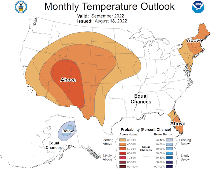
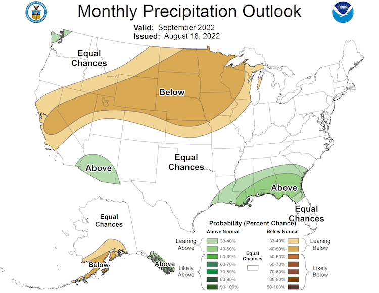
The Climate Prediction Center's monthly outlook for September shows:
- Increased temperatures are likely across New Mexico and western Texas.
- The monthly outlook shows equal chances of above- or below-normal precipitation across the Southern Plains for September.
September 2022 Temperature Outlook
September 2022 Precipitation Outlook
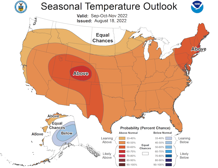
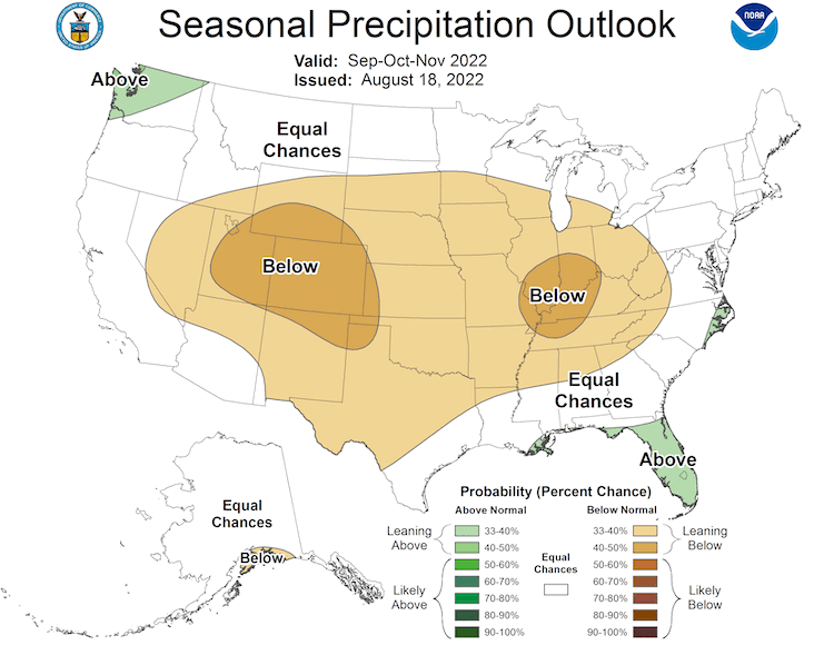
3-Month Outlook for September–November 2022
- Seasonal forecasts for September—November show a hotter-than-normal season ahead for the Southern Plains
- Lower-than-normal precipitation is more likely for Kansas, Oklahoma, northern and western Texas, and eastern New Mexico.
Three-Month Temperature Outlook: September–November 2022
Three-Month Precipitation Outlook: September–November 2022
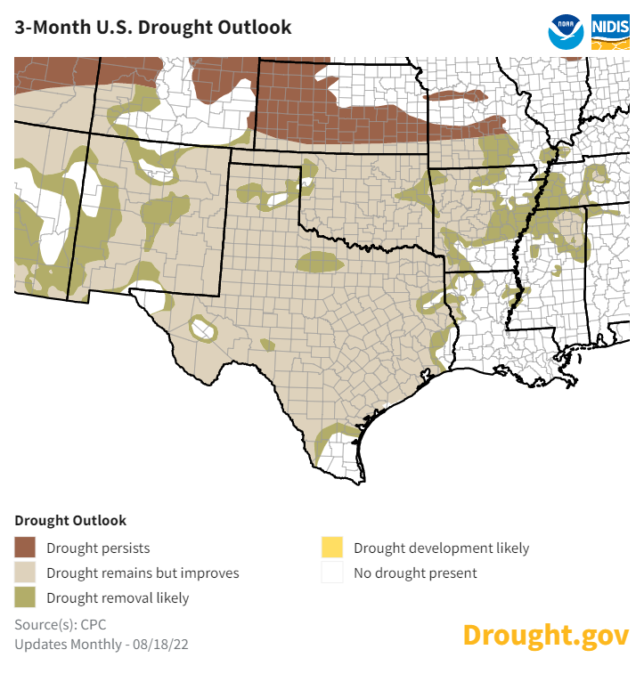
Seasonal Drought Outlook
- Partly due to the recent rains and in anticipation for the transition to the fall season, drought is expected to remain but mostly improve for Oklahoma, Texas, and New Mexico over the next three months compared to August 16 conditions.
- Drought conditions in Kansas are likely to persist through fall.
August 18–November 30 Drought Outlook
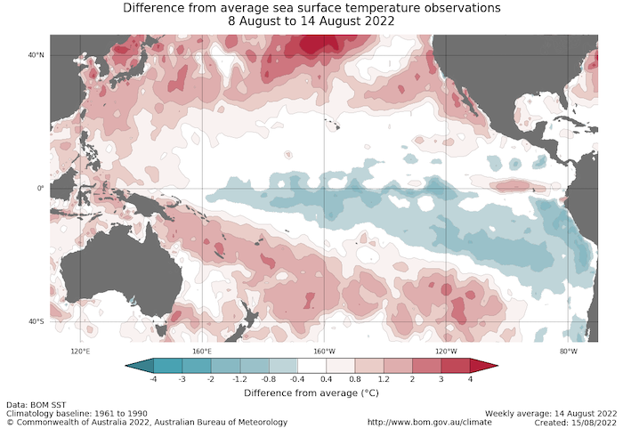
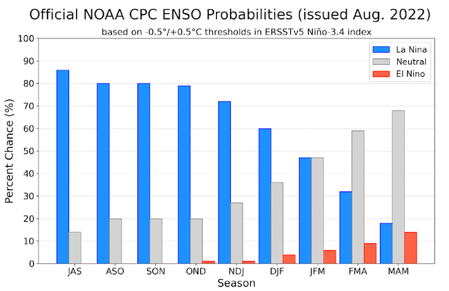
La Niña Persists and May Impact Winter Weather
- One of the primary drivers of drought across the Southwest, including western Texas, through winter and spring was a La Niña pattern in the Pacific.
- The latest CPC ENSO discussion maintains a La Niña Advisory. La Niña is expected to continue, with chances for La Niña gradually decreasing from 86% in the coming season to 60% during December–February 2022–23. El Niño is unlikely.
- A third La Niña pattern in winter would favor another dry winter ahead for the Southern Plains and the Southwest U.S. (learn more).
- No two La Niña patterns are the same. For more information, please check out the NOAA El Niño–Southern Oscillation (ENSO) blog.
Sea Surface Temperature Anomalies (°C) for August 8–14, 2022
Probability of El Niño, La Niña, or Neutral Conditions
State-Based Conditions and Impacts
Kansas
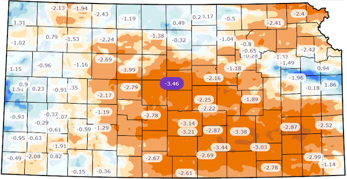
- For the period June 1–August 21, 2022, the statewide average temperature was 2.3 degrees above normal, and average precipitation was 77% of normal (a deficit of 2.2 inches). Northwest and west-central Kansas are the most above normal for temperature (+3.0 to +3.4) but also have the lowest percentage of precipitation (55% to 59%).
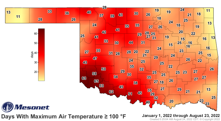
- Many locations statewide have had above-normal 100°+ days thus far in 2022, including Dodge City (31°, normal 24°), Wichita (23°, normal 12°), Goodland (16°, normal 6°) and Chanute (23°, normal 5°).
- The percent area of exceptional drought (D4) increased from 3% to 11% since mid-July; this is the largest amount of D4 area in the state since August 2013.
- There have been widespread corn and soybean failures due to lack of rain and untimely heat. Corn has large nitrate values, especially with recent rains and the toxic silage.
- Sorghum, typically a drought tolerant crop, is struggling to head out and short in the west.
- Streamflows continue to fall with several below Minimum Desirable Flow and producers are applying to spend additional irrigation out of flex groundwater accounts.
Oklahoma
- Heavy rains brought relief to far-southern and west-central Oklahoma, but most of the state missed out on the most significant moisture.
- The extreme heat that had plagued the state since early June also lessened to some degree.
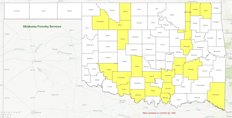
- Twenty-two Oklahoma counties remained in a burn ban as of August 24.
- Oklahoma’s cotton crop became severely impacted by drought and heat with 62% rated poor or very poor on August 21 according to USDA reports.
Texas
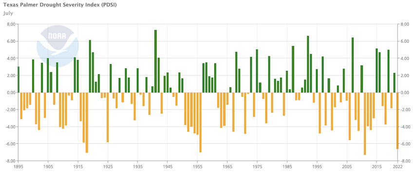
- The statewide Palmer Drought Severity Index was -6.60 at the end of July. This is the fourth-lowest July value on record.
- Year-to-date statewide average rainfall was 8.93 inches as of July 31. This is the second driest January–July on record, behind only 2011.
- The statewide average precipitation in August was more than 3.50 inches with a week remaining in the month. However, without substantial additional rainfall the January–August period would still be the second-driest in over half a century.
For More Information
NIDIS and its partners will issue future drought updates as conditions evolve.
More local information is available from the following resources:
In Case You Missed It
- July 21, 2022: 2022 U.S. Drought and Heat Webinar: The Southern Plains
Prepared By
Joel Lisonbee
NOAA/National Integrated Drought Information System (NIDIS), Southern Plains Drought Early Warning System and CIRES/CU Boulder
Gary McManus
Oklahoma State Climatologist, Oklahoma Mesonet, Oklahoma Climatological Survey
Chip Redmond
Kansas State University
Matthew Sittel
Kansas Assistant State Climatologist, Kansas State University
John Nielsen-Gammon
Texas State Climatologist, Texas A&M University
Southern Regional Climate Center
Victor Murphy
National Weather Service
This drought status update is issued in partnership between the National Oceanic and Atmospheric Administration (NOAA) and the offices of the state climatologist for Texas, Oklahoma, New Mexico, and Kansas. The purpose of the update is to communicate a potential area of concern for drought expansion and/or development within the Southern Plains based on recent conditions and the upcoming forecast. NIDIS and its partners will issue future drought updates as conditions evolve.
