Apalachicola-Chattahoochee-Flint (ACF) River Basin Drought & Water Dashboard
NOAA's National Integrated Drought Information System (NIDIS) and National Centers for Environmental Information (NCEI)
The Apalachicola, Chattahoochee, and Flint (ACF) Rivers, along with the Apalachicola Bay, link the people and natural systems of Alabama, Florida, and Georgia. Balancing the water needs between three states and various sectors creates complex water management challenges, which are further intensified during times of drought.
The ACF River Basin Drought and Water Dashboard is a web-based application that allows decision makers to view real-time information on the ACF River Basin with interactive, shareable, and easy-to-understand graphics on current and predicted drought conditions all in one place.
Users can view current conditions (including streamflow, reservoir, and soil moisture conditions), outlooks and forecasts, drought impacts (e.g., on agriculture wildfire, and public health), and historical drought information at both the basin and county level. The Dashboard also features a Story Map, "Drought in the ACF River Basin," which provides context for the data & maps throughout the Dashboard, exploring the historical context and impacts of drought on the basin.
The Dashboard was developed as part of a NIDIS-supported project implemented by Albany State University Water Planning and Policy Center, Auburn University Water Resources Center, and NOAA’s National Centers for Environmental Information (NCEI). It was created in response to stakeholder feedback in close collaboration with the states of Alabama, Florida, and Georgia, the U.S. Army Corps of Engineers, and other local partners.
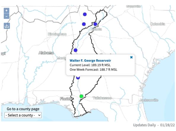
Projects within the ACF River Basin—Lake Seminole, West Point Lake, Walter F. George Reservoir, and Lake Sidney Lanier—as well as Allatoona and Carters in the adjacent ACT River Basin, are color coded based on USACE lake action zones. For Lake Seminole (Jim Woodruff Dam), which has no action zones, green = below maximum operating level, and blue = above maximum operating level. Current levels are also displayed for two additional projects in the ACT River Basin—R.F. Henry and William Dannelly—which do not have lake action zones or forecast information. Navigation restrictions in the action zones below do not apply to Allatoona and Carters, as navigation is only directly supported for reservoirs in the ACF Basin.
Current lake level information is ingested daily from U.S. Army Corps of Engineers website. Lake level forecast data are ingested weekly via parsed PDF file. Current and forecasted lake data are joined to a shapefile for visualization.
USACE Lake Action Zones
Projects within the ACF River Basin—Lake Seminole, West Point Lake, Walter F. George Reservoir, and Lake Sidney Lanier—as well as Allatoona and Carters in the adjacent ACT River Basin, are color coded based on USACE lake action zones. For Lake Seminole (Jim Woodruff Dam), which has no action zones, green = below maximum operating level, and blue = above maximum operating level. Current levels are also displayed for two additional projects in the ACT River Basin—R.F. Henry and William Dannelly—which do not have lake action zones or forecast information. Navigation restrictions in the action zones below do not apply to Allatoona and Carters, as navigation is only directly supported for reservoirs in the ACF Basin.
Current lake level information is ingested daily from U.S. Army Corps of Engineers website. Lake level forecast data are ingested weekly via parsed PDF file. Current and forecasted lake data are joined to a shapefile for visualization.
Access
ACF River Basin Drought & Water Dashboard
- ACF Maps & Data: Interactive, easily shareable maps showing current conditions (including streamflow & reservoir information), drought impacts, outlooks and forecasts, and historical drought information for the ACF River Basin.
- Drought in the ACF River Basin Story Map: Historical context on what drought looks like in the ACF Basin, a primer on how water resources are managed in the ACF, and a look ahead to the future.
- Additional Resources: Basin-wide drought resources, including climate and drought webinars; data, maps, and tools for exploring current conditions and forecasts; and key state contacts who you can reach out to for more information on drought in the ACF Basin.
Documentation
Research Profile: The Apalachicola-Chattahoochee-Flint (ACF) River Basin Drought & Water Dashboard
Learn about the NIDIS-funded research that led to the creation of the ACF Dashboard.
ACF Dashboard: Maps & Data
Documentation of all the maps and statistics available through the ACF Dashboard.