Additional Drought Resources for the Apalachicola-Chattahoochee-Flint River Basin
Key Resources for Regional and Local Drought Information
Below are key regional and state contacts that you can reach out to for more information on drought in the Apalachicola-Chattahoochee-Flint (ACF) River Basin.
Southeast Climate Monthly Webinar Series
This webinar series provides timely information on current and developing climate conditions (drought, floods, tropical storms, etc.), climatic events like El Niño and La Niña, and impacts of these conditions on topics such as wildfires, agriculture production, and disruption to water supply and ecosystems. Webinars are held on the fourth Tuesday on the month at 10 a.m. ET.
Southeast Drought Early Warning System (DEWS)
The Southeast DEWS is a collaborative federal, regional, state, and local interagency effort to improve drought early warning capacity and build long-term drought resilience throughout the region. Sign up for Southeast Drought Early Warning System updates.
National Weather Service Drought Information Statements
The National Weather Service Weather Forecast Offices (WFOs) may issue a drought information statement when the U.S. Drought Monitor indicates a drought intensity of Extreme Drought (D3) or greater in any portion of the WFO’s county warning and forecast area. These statements may also be issued when Moderate to Severe Drought (D1 or D2) designations are present or when drought impacts have been reported in the local area.
Drought.gov: Current Drought Conditions and Forecasts by Location

Alabama Resources and Contacts
Alabama Drought Planning and Management, Alabama Department of Economic and Community Affairs (ADECA), Office of Water Resources
Provides a comprehensive overview of Alabama’s Drought Planning and Response Act, Drought Management Plan and Regions, Drought Data Portal, and current Drought Declarations.
Alabama Office of the State Climatologist
Alabama Groundwater Assessment Program, Geological Survey of Alabama
Includes real-time monitoring network of wells.
Alabama Drought Reach, a program that is improving drought communications and drought impact monitoring in Alabama.
Drought.gov Alabama State Page
Provides state-level and media-friendly information on current and historical conditions. You can also access county- and local-level drought information.

Florida Resources and Contacts
Northwest Florida Water Management District
Provides a broad range of information on water supply, water quality, flood protection, and natural system protection.
Florida Climate Center and State Climatologist
Drought.gov Florida State Page
Provides state-level and media-friendly information on current and historical conditions. You can also access county- and local-level drought information.

Georgia Resources and Contacts
Georgia Drought Management, Environmental Protection Division
Provides information on the recent Drought Management Rules, withdrawal permits, and Drought Indicators and Triggers reports.
Office of the Georgia State Climatologist
Current Drought Status for Metropolitan North Georgia Water Planning District
Georgia Drought Water Conservation Plan
Georgia Drought Management Rules
Georgia Drought Monitoring Reports
Drought.gov Georgia State Page
Provides state-level and media-friendly information on current and historical conditions. You can also access county- and local-level drought information.

Key Federal Water Resources
Other ACF Drought Resources
Key Drought and Water Management Documents
A collection of important documents for drought planning and sustainable water resources management in the ACF River Basin.


Key Water Resources Data & Maps
A collection of data, maps, and tools for monitoring water resources in the ACF River Basin, including streamflow, groundwater, and reservoir information.
The National Water Dashboard is an interactive map viewer that shows provisional real-time water data from more than 13,000 USGS observation stations in context with weather-related data
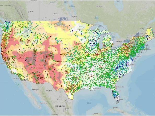
The National Groundwater Monitoring Network (NGWMN) is a compilation of selected groundwater monitoring wells from federal, state, and local groundwater monitoring networks across the nation.
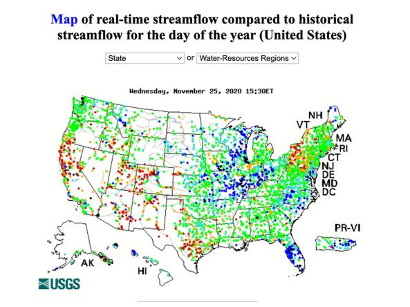
WaterWatch is a U.S. Geological Survey (USGS) World Wide Web site that displays maps, graphs, and tables describing real-time, recent, and past streamflow conditions for the United States.
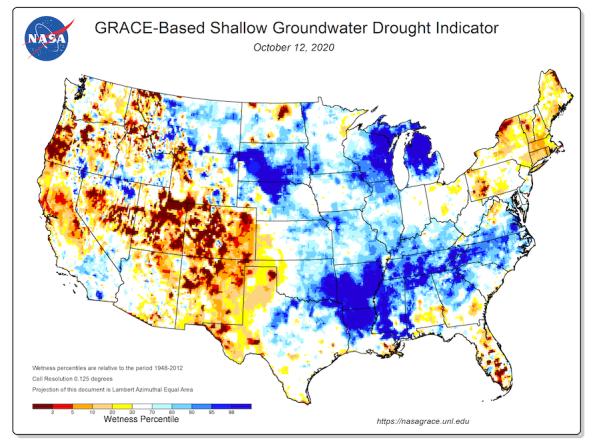
Groundwater and soil moisture drought indicators based on terrestrial water storage observations derived from GRACE satellite data and integrated with other observations, produced each week by NASA
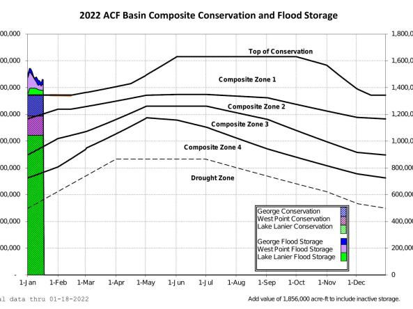
The US Army Corps of Engineers provides current, forecasted, and historical project data for the five federally operated reservoirs in the ACF River Basin.
Key Sector Impacts Data & Maps
A collection of data, maps, and tools for monitoring drought impacts across economic sectors, including agriculture, wildfire management, and public health.
The National Agricultural Statistics Service (NASS) conducts hundreds of surveys every year and prepares reports covering virtually every aspect of U.S. agriculture.
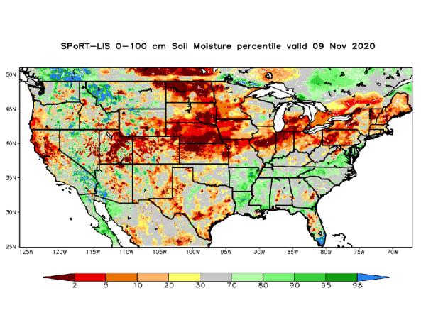
NASA’s Short-term Prediction and Transition Center – Land Information System (SPoRT-LIS) provides high-resolution (about 3-km) gridded soil moisture products in real-time to support regional and lo
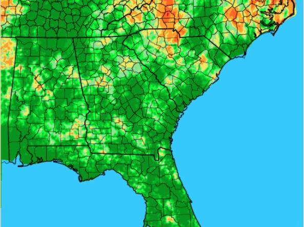
The Lawn and Garden Moisture Index measures the capacity of current soil moisture to sustain healthy lawns and gardens in the Southeast U.S.

The Keetch-Byram Drought Index assesses the risk of fire by representing the net effect of evapotranspiration and precipitation in producing cumulative moisture deficiency in deep duff and upp
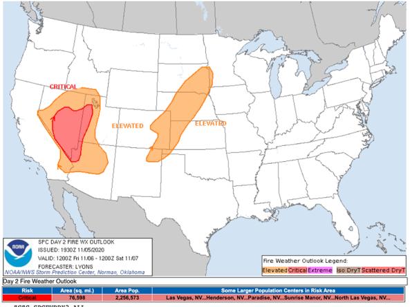
The National Weather Service's Fire Weather Outlooks are intended to delineate areas of the continental U.S.
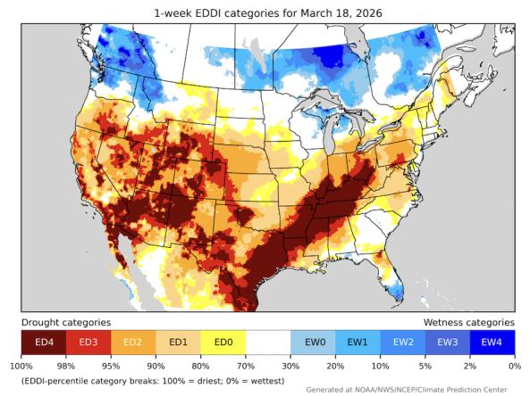
The Evaporative Demand Drought Index (EDDI) is an experimental tool that examines how anomalous the atmospheric evaporative demand (E0; also known as "the thirst of the atmosphere") is for a given
Key Meteorological Conditions Data & Maps
A collection of tools for monitoring and forecasting precipitation, temperature, and other weather conditions in the ACF River Basin.
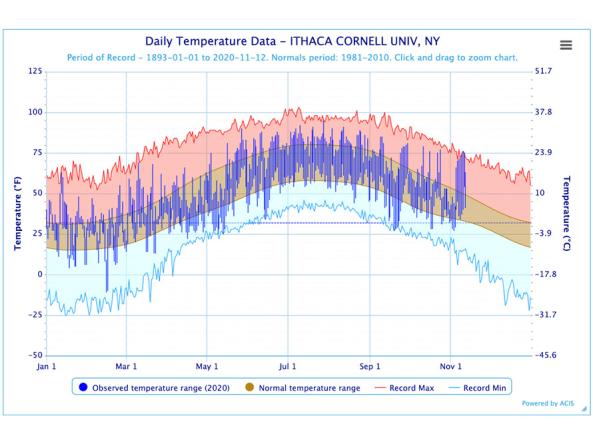
The Regional Climate Centers (RCC) Applied Climate Information System (ACIS) offers interactive temperature and precipitation charts with single- or multi-station capabilities.
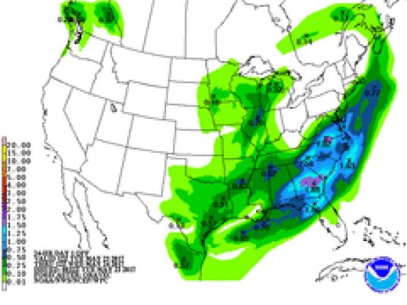
NWS WPC produces Quantitative Precipitation Forecasts (QPFs) that depict the amount of liquid precipitation expected to fall in a defined period of time.
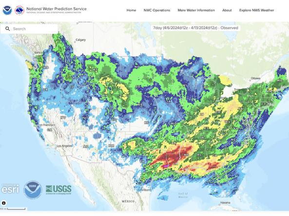
The National Weather Service's National Water Prediction Service (NWPS) provides short-term observed and climatic trends of precipitation across the lower 48 United States (CONUS), Puerto Ric
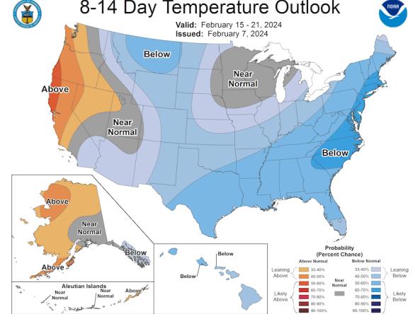
The Climate Prediction Center (CPC) produces temperature and precipitation outlooks for the U.S., including 6-10 day, 8-14 day, monthly, and seasonal outlooks.
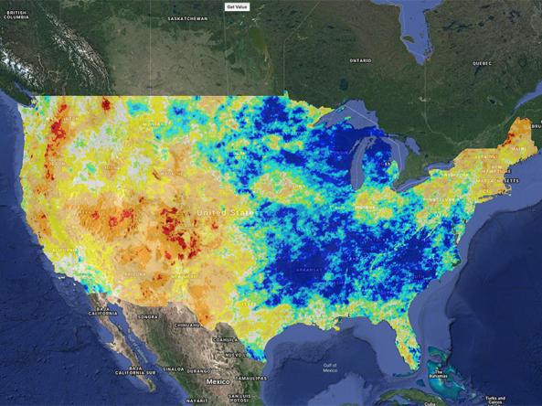
Climate Engine allows users to analyze and interact with climate and earth observations for decision support related to drought, water use, agricultural, wildfire, and ecology.
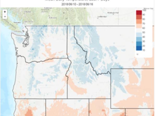
The Climate Toolbox is a collection of web tools for visualizing past and projected climate and projected climate and hydrology of the contiguous United States of America.