Current Areas in Drought Likely to Persist Through September
Key Points
- August rainfall has helped improve drought conditions in some portions of the Midwest (southern Missouri, central Minnesota, northern Wisconsin, central Illinois, western Indiana, and western Kentucky), while other areas have not been so lucky (southern Iowa, western Illinois, northern Missouri).
- As of August 30, drought is affecting 10% of the Midwest region, with the most intense areas in northwestern Iowa and southwestern Missouri (extreme drought, D3), and southern Iowa and east-central Minnesota (severe drought, D2).
- Overall, corn and soybean crops are in good condition across the region; however, yields are expected to be lower in the areas that have been dealing with drought this summer, particularly in Iowa and Missouri.
- Some areas are also showing signs of hydrological drought, including reduced surface water, streamflow, and groundwater levels. In southern Minnesota, lake levels are low and boaters are having issues launching and retrieving boats.
- The September monthly precipitation outlook shows below-normal precipitation is likely across Minnesota, Iowa, and Wisconsin, with above-normal temperatures as well. As a result, drought conditions are likely to persist through September.
- Drought impacts will be less severe as the growing season is coming to an end; however, hydrological impacts to surface water, streamflow and groundwater could increase the longer the drought persists.
Current U.S. Drought Monitor map for the Midwest Drought Early Warning System (DEWS) with data valid for August 30, 2022. The U.S. Drought Monitor (USDM) is updated each Thursday to show the location and intensity of drought across the country. Drought categories show experts’ assessments of conditions related to dryness and drought including observations of how much water is available in streams, lakes, and soils compared to usual for the same time of year.
U.S. Drought Monitor Categories
Abnormally Dry (D0)
Abnormally Dry (D0) indicates a region that is going into or coming out of drought. View typical impacts by state.
Moderate Drought (D1)
Moderate Drought (D1) is the first of four drought categories (D1–D4), according to the U.S. Drought Monitor. View typical impacts by state.
Severe Drought (D2)
Severe Drought (D2) is the second of four drought categories (D1–D4), according to the U.S. Drought Monitor. View typical impacts by state.
Extreme Drought (D3)
Extreme Drought (D3) is the third of four drought categories (D1–D4), according to the U.S. Drought Monitor. View typical impacts by state.
Exceptional Drought (D4)
Exceptional Drought (D4) is the most intense drought category, according to the U.S. Drought Monitor. View typical impacts by state.
Current U.S. Drought Monitor map for the Midwest Drought Early Warning System (DEWS) with data valid for August 30, 2022. The U.S. Drought Monitor (USDM) is updated each Thursday to show the location and intensity of drought across the country. Drought categories show experts’ assessments of conditions related to dryness and drought including observations of how much water is available in streams, lakes, and soils compared to usual for the same time of year.
Current Conditions and Impacts
Current Conditions
- August rainfall has helped improve drought conditions in some portions of the Midwest (southern Missouri, central Minnesota, northern Wisconsin, central Illinois, western Indiana, and western Kentucky), while other areas have not been so lucky (southern Iowa, western Illinois, northern Missouri) (Figure 1).
- Drought is currently affecting 10% of the Midwest region. The most intense areas of drought are in northwestern Iowa and southwestern Missouri (extreme drought – D3) and southern Iowa and east-central Minnesota, near the Twin Cities (severe drought – D2).
- The two pockets of extreme drought have very different evolutions. Despite some relief over the winter of 2021–22, drought in northwestern Iowa has been persistent since summer 2020. On the other hand, extreme drought in southwestern Missouri had quick onset this summer, beginning in mid-July.
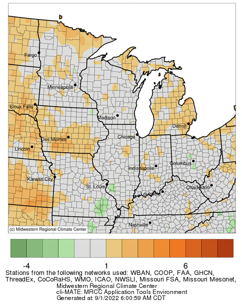
- Drought in southern Iowa has also rapidly intensified since late July (currently at severe drought – D2) as a result of below-normal rainfall (Figure 2) and slightly above-normal temperatures (Figure 3). West-central Illinois and northern Missouri have also only received 10%–25% of their normal August rainfall.
- On the other hand, southern Missouri and western Kentucky have benefited from above-normal rainfall the last 30 days, which has improved drought by one to three categories on the U.S. Drought Monitor. August rainfall has also brought some drought relief to east-central Illinois, which has been in drought since mid-June, peaking at severe drought (D2).
- For the most part, temperatures over the last 30 days have been near-normal across much of the region (Figure 3), which has helped conditions by limiting overall evaporative demand (i.e., more water stays on the surface, as opposed to evaporation to the atmosphere).
Figure 1. 4-Week Change Map for the U.S. Drought Monitor
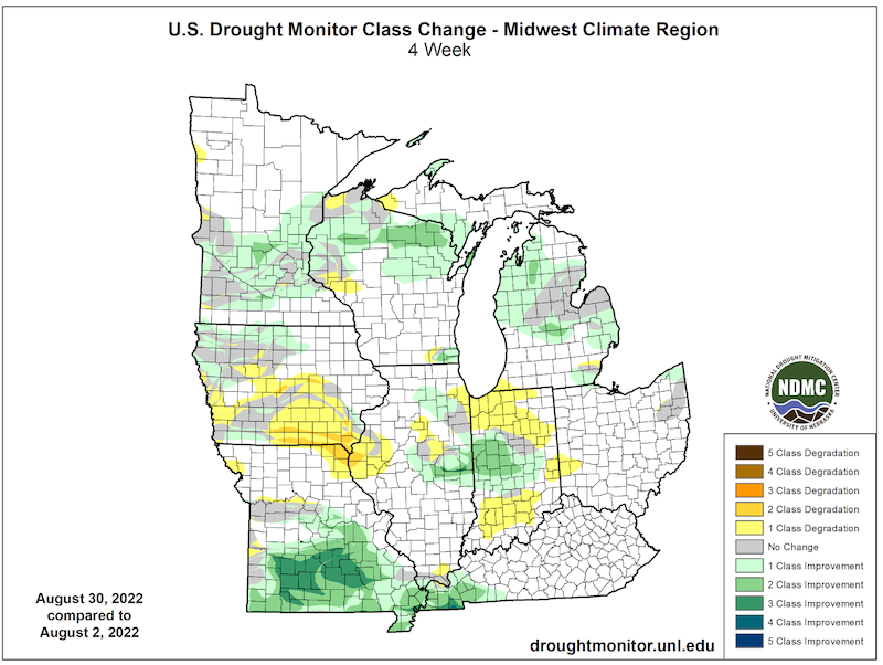
Figure 2. 30-Day Percent of Normal Precipitation (August 3–September 1, 2022)
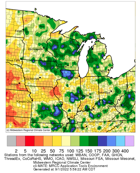
Figure 3. 30-Day Departure from Normal Temperature (°F) (August 3–September 1, 2022)
Drought Impacts
- Soil moisture is lacking in some states across the Midwest. According to the U.S. Department of Agriculture (USDA), soil moisture is reported to be “short to very short” across 52% of Missouri, 45% of Iowa, and 43% of Indiana (Figure 4).
- USDA reports that corn and soybeans are in good condition across much of the region, and spring wheat is in good condition in Minnesota (the only state where it is grown in the Midwest).
- However, corn and soybean yields are likely to be lower in the areas that have experienced drought this summer (particularly in northwestern and southern Iowa, and southern Missouri). In northwestern Iowa and portions of Missouri, some farmers have begun chopping corn for silage due to the damage from drought. August rainfall has helped soybeans in these areas a bit, but 18% and 10% of soybeans are reported to be in “poor to very poor” condition in Missouri and Iowa, respectively.
- The majority of corn crops are rated in “good to excellent” condition across all Midwest states except Kentucky (Figure 5). In Kentucky, only 31% of the corn is rated as good to excellent. However, this number reflects not only the impact of drought in the western part of the states earlier this summer (August rains came too late to help corn), but also crop damage from flooding in the east during August.
- In Minnesota, the apple crop has been delayed by a couple of weeks due to drought, and apples may be smaller this year due to lack of rainfall. Also, apples were not turning red, likely due to more sunshine and higher nighttime low temperatures.
- Some areas of the Midwest are showing signs of hydrological drought as well. The USGS Climate Response Network (which includes wells to monitor the effects of drought and other climate variability) shows that wells in northern Indiana, eastern Illinois, Michigan, southern Wisconsin, and Iowa are showing below-normal groundwater levels (Figure 6).
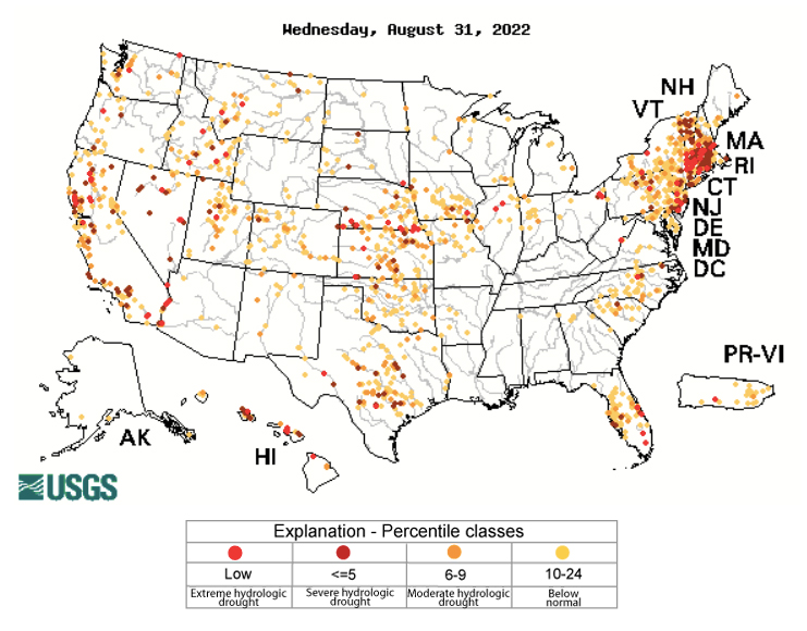
- Average streamflows for the last 28 days are also showing moderate to extreme hydrologic drought, mainly in western portions of the region (Figure 7).
- In southern Minnesota, lake levels are low, and this is causing boaters problems with launching and retrieving boats. Minnesota Department of Natural Resources crews are repairing and extending many boat launch ramps so the public can continue to enjoy boating, despite the low water conditions.
Report your drought impacts through the Condition Monitoring Observer Reports (CMOR):
Figure 4. Topsoil Moisture – Percent Short to Very Short (Week ending August 28, 2022)
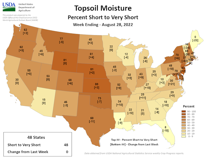
Figure 5. USDA-NASS Corn Condition Report for August 28, 2022
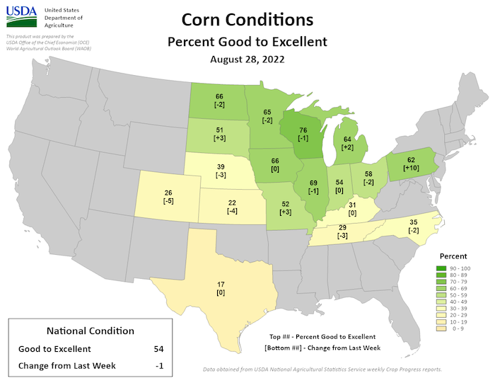
Figure 6. USGS Climate Response Network – Groundwater Percentiles (August 31, 2022)
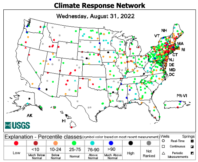
Figure 7: USGS 28-Day Average Streamflow Compared to Historical Streamflow (Wednesday, August 31, 2022)
Outlook and Potential Impacts
- The short-term precipitation outlook for September 9–15 shows the possibility for above-normal precipitation across southern portions of the region, near-normal precipitation across the central Midwest, and below-normal precipitation across Minnesota (Figure 8). Temperatures are likely to be above normal.
- Unfortunately, the Climate Prediction Center's monthly precipitation outlook shows that some of the areas still in drought (Iowa, Minnesota) are likely to have below-normal precipitation in September (Figure 9), and temperatures are expected to be above normal as well (Figure 10).
- With this outlook for September 2022, it is likely that drought conditions will persist where currently present, with the potential for some drought development as well.
- While drought is likely to persist, with the growing season almost over, the impacts won’t be as severe. However, hydrological impacts could increase if drought continues—meaning that soil moisture and surface water, streamflow, and groundwater levels could continue to decline.
- Ecological impacts could also increase with reduced availability of water overall.
Figure 8. 8–14 day Precipitation Outlook (Valid September 9–15, 2022)
Figure 9. Monthly Precipitation Outlook for September 2022
Figure 10. Monthly Temperature Outlook for September 2022
For More Information
- NIDIS and its partners will issue future updates as conditions evolve.
- More local information is available from the following resources:
- To report or view local drought impact information:
- Report your drought impacts through Condition Monitoring Observer Reports (CMOR)
- View CoCoRaHS Condition Monitoring reports.
- The upcoming North Central U.S. Climate and Drought Summary & Outlook Webinar on September 15, 2022 will offer updated information about conditions, impacts, and outlooks. The recordings for the webinar can be found here.
Prepared By
Molly Woloszyn
NOAA/National Integrated Drought Information System (NIDIS), CIRES/University of Colorado Boulder
Dennis Todey & Laurie Nowatske
USDA Midwest Climate Hub
Doug Kluck
NOAA/National Centers for Environmental Information
Melissa Widhalm
Midwestern Regional Climate Center/Purdue University
Ray Wolf & Audra Bruschi
NOAA/National Weather Service
This drought status update is issued in partnership between the National Oceanic and Atmospheric Administration (NOAA) and the U.S. Department of Agriculture (USDA) to communicate a potential area of concern for drought expansion and/or development within the Midwest U.S. based on recent conditions and the upcoming forecast. NIDIS and its partners will issue future drought status updates as conditions evolve.

