Snow Drought, Winter Warmth, and Spring Fire Danger
Key Points:
- Moderate Drought (D1) continued for Nantucket and several counties in western New York state. Abnormally Dry (D0) conditions persisted in all or some of 12 western New York counties.
- Groundwater levels on Nantucket are recovering, but still are not in the normal range as precipitation is still below normal over the last year or more.
- While we are keeping an eye on western New York state and Nantucket, there are some early concerns for northern Maine. Limited snowpack, localized precipitation deficits, February and early March warmth, and an expected continuation of warmer-than-normal conditions warrants increased scrutiny for this area.
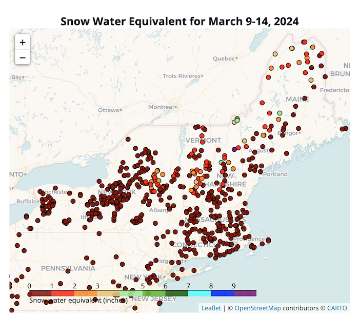
- With 6 weeks of data in, the Northeast Regional Climate Center’s Snow Survey map for the Northeast depicts no snow or low snow water equivalent (SWE) in the snowpack outside of higher elevations in northern New England and New York’s Adirondacks.
- New York state’s burn ban went into effect on March 16.
Accumulated precipitation deficits (inches) for sites across the Northeast from September 1, 2023 to March 19, 2024.
Three sites in northern Maine (Fort Kent, Van Buren, and Caribou) and three sites in western New York (Silver Springs, Batavia, and Buffalo) show precipitation deficits for this period.
Drought is defined as the lack of precipitation over an extended period of time, usually for a season or more, that results in a water shortage. Changes in precipitation can substantially disrupt crops and livestock, influence the frequency and intensity of severe weather events, and affect the quality and quantity of water available for municipal and industrial use.
Learn MorePeriods of drought can lead to inadequate water supply, threatening the health, safety, and welfare of communities. Streamflow, groundwater, reservoir, and snowpack data are key to monitoring and forecasting water supply.
Learn MoreStations
Accumulated precipitation deficits (inches) for sites across the Northeast from September 1, 2023 to March 19, 2024.
Three sites in northern Maine (Fort Kent, Van Buren, and Caribou) and three sites in western New York (Silver Springs, Batavia, and Buffalo) show precipitation deficits for this period.
Drought is defined as the lack of precipitation over an extended period of time, usually for a season or more, that results in a water shortage. Changes in precipitation can substantially disrupt crops and livestock, influence the frequency and intensity of severe weather events, and affect the quality and quantity of water available for municipal and industrial use.
Learn MorePeriods of drought can lead to inadequate water supply, threatening the health, safety, and welfare of communities. Streamflow, groundwater, reservoir, and snowpack data are key to monitoring and forecasting water supply.
Learn MoreCurrent Conditions for the Northeast
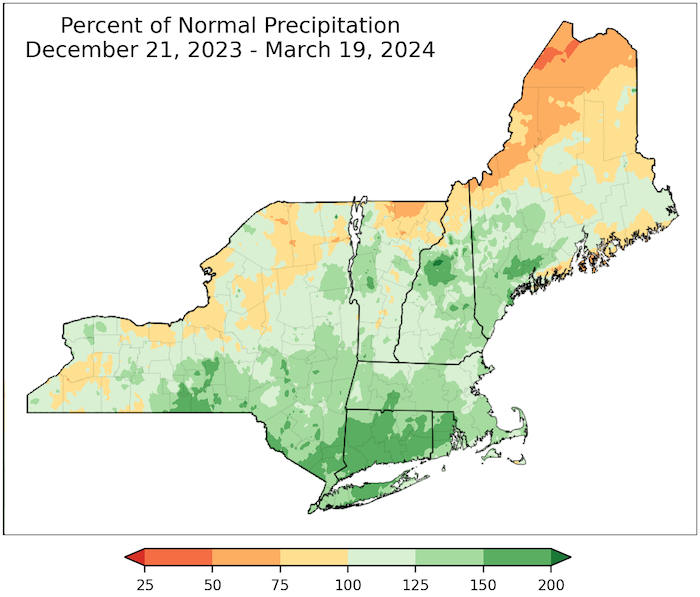
The first half of March featured record warmth and record amounts of precipitation but record low snowfall. Longer-term precipitation deficits remain in some areas.
Soil moisture maps currently do not indicate deficits, but with a low snow winter and anticipated warmer weather, these are areas that require close scrutiny over the next few months.
90-Day Percent of Normal Precipitation
Snow Drought: Snow Water Equivalent for March 9–14, 2024
The Northeast Regional Climate Center's Snow Survey map represents the water equivalent of the snowpack as measured at survey sites around New York and New England. Snow surveys are taken every two weeks from early January to as late as early May, depending on the snowpack. Except for higher elevations in northern New England and New York’s Adirondacks, snow water equivalent (SWE) is low at sites across the Northeast.
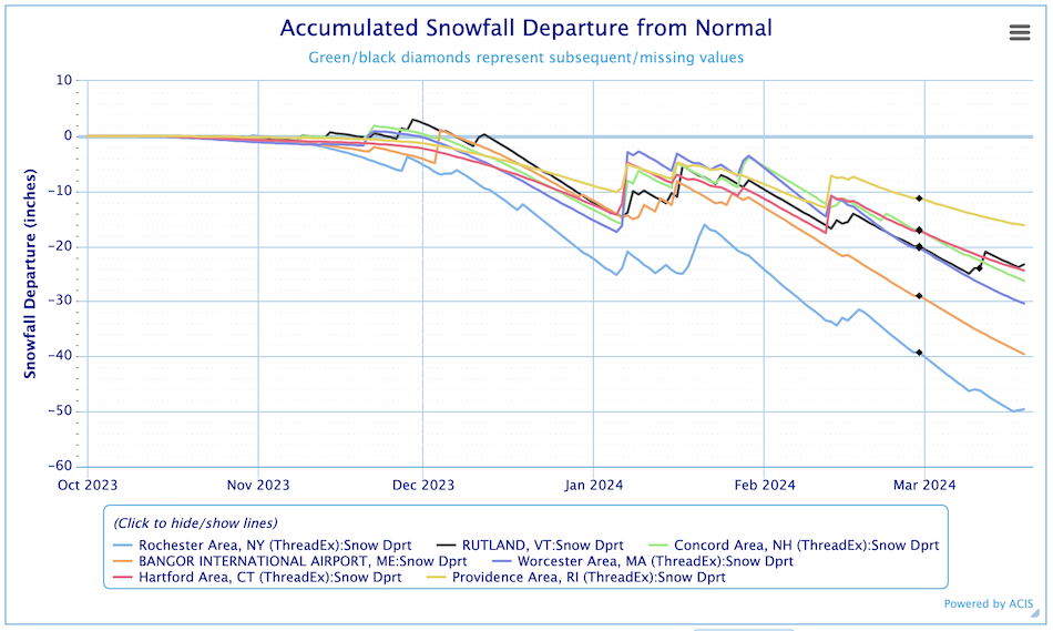
Accumulated Snowfall Departure from Normal
This chart plots the snowfall departure from normal for selected sites across the region. Across much of the Northeast, there is under an inch of snow water equivalent, with northern portions of the region faring better at 2–5 inches of snow water equivalent. This snowfall deficit will impact groundwater recharge.
Drought Impacts in the Northeast
- The Massachusetts Islands Region is in Mild Drought, according to the Massachusetts Drought Task Force. The Drought Task Force will meet again in early April.
- New York State’s annual brush burn ban went into effect on March 16.
- New England states have open burn rules and restrictions:
- Connecticut: Open Burning Restrictions
- Massachusetts: Open Burning Safety
- Maine: New Open Burning Law
- New Hampshire: Open Burning
- Rhode Island: Regulation of Burning Open Fires
- Vermont: Open Burning Rules
- New York:
- Orange County Wildfire report on March 14, 2024 - Fire sparked by logging equipment
- Snow Drought
For Regional Awareness
- The first half of March was characterized by record warmth for multiple sites in New York and New England including Syracuse, Albany, Central Park, Hartford, and Caribou. This is a continuation of unusually warm conditions experienced in February as well as for much of this winter.
- Massachusetts released its new Drought Management Plan in December 2023.
Consider reporting and sharing your local drought impacts to help inform the U.S. Drought Monitor authors, our neighbors, and drought mitigation response agencies. Comments on snow cover and your photos are greatly appreciated, too.
View an interactive map of CMOR reports. See what your county is reporting and add to the impact dataset.
Looking Ahead: Outlooks for the Northeast
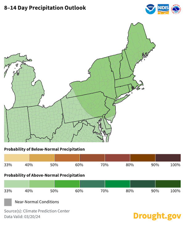
- As of March 20, 2024, NOAA's Climate Prediction Center's (CPC) 8-14 day outlooks (valid March 28–April 3) predict increased chances for warmer-than-normal temperatures for most of the region. Chances for above-normal precipitation will counter the potential for drying driven by the warmth.
- The CPC's 3-4 week outlook maintains increased chances for warmer-than-normal temperatures but sees equal chances for near-normal precipitation. Precipitation in any form will help hold off the emergence of dryness across the region.
8–14 Day Precipitation Outlook
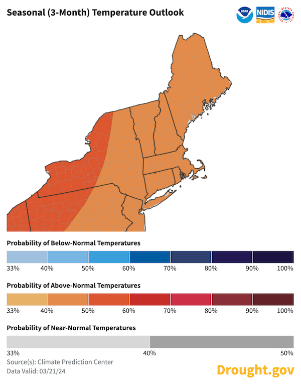
- Looking ahead to early summer, according to CPC's seasonal temperature outlook, the chances for above-normal temperatures hold for this extended period, raising concern for the drying soils as daylight hours increase.
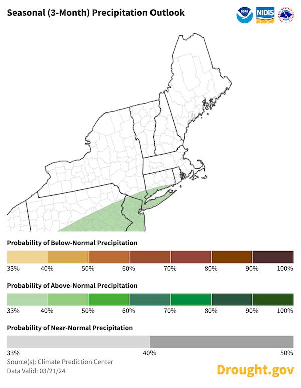
- According to CPC's seasonal precipitation outlook, there are equal chances for near-normal precipitation for most of the region, but the southern New England coastal states have slightly better chances for above-normal precipitation.
April–June 2024 Precipitation Outlook
April–June 2024 Temperature Outlook
- The Drought.gov Outlooks and Forecasts page and state drought pages also provide maps and descriptions of anticipated temperature and precipitation conditions.
Additional Resources
Additional Sites for Monitoring Snowfall and Snowpack
- The Northeast River Forecast Center (NERFC) snow page offers a regional perspective on snow conditions. Data and maps with daily snowfall observations, snow depth, and forecasted snow melt provide near real-time data for monitoring and decision making.
- The National Operational Hydrologic Remote Sensing Center also offers data on the northeast snow pack along with station observations and gridded analysis products.
- The Maine Cooperative Snow Survey site, provided by the Maine Geological Survey, includes observational data for selected sites, maps and graphics.
Other Resources
- Look back at previous Northeast DEWS Drought Status Updates.
- Northeast Drought Early Warning System Dashboard.
- Sign up for NIDIS emails on our email sign up form.
- Your local National Weather Service office.
- NOAA Regional Climate Services Monthly Webinar Series (next webinar is March 28).
- USDA Northeast Climate Hub.
- USGS New England and New York Water Science Centers.
- Explore drought information for your state:
- Connecticut Drought Information Center
- Maine Drought Task Force
- Massachusetts Drought Management Task Force
- New Hampshire Department of Environmental Services: Drought
- New York State Department of Environmental Conservation (DEC): Drought
- Rhode Island Water Resources Board: Drought Management Program
- Vermont Agency of Natural Resources, Department of Environmental Conservation: Drought and Other Hazards
Prepared By
Sylvia Reeves
NOAA/National Integrated Drought Information System (NIDIS), CU Boulder/Cooperative Institute for Research in Environmental Sciences (CIRES)
Samantha Borisoff, Jessica Spaccio, Keith Eggleston, Art DeGaetano
Northeast Regional Climate Center
Ellen L. Mecray
Regional Climate Services Director, Eastern Region, NOAA
Gardner Bent
USGS New England Water Science Center
In partnership with National Weather Service Offices of the Northeast and State Climate Offices of the Northeast.
This drought status update is issued in partnership between the National Oceanic and Atmospheric Administration (NOAA), U.S. Geological Survey, and the U.S. Department of Agriculture (USDA) to communicate concern for drought expansion and intensification within the Northeast U.S. based on recent conditions and the forecasts and outlooks. NIDIS and its partners will issue future drought status updates as conditions evolve.
