Exceptional drought persists in Texas, Oklahoma, New Mexico, and Kansas.
Key Points
- Extreme (D3)/exceptional (D4) drought remains over eastern New Mexico, western Oklahoma, southwest Kansas, and much of central and west Texas.
- Heavy rains in the past 30 days have relieved drought across much of eastern Oklahoma, and expected rainfall should bring more improvement.
- Exceptional drought (D4) expanded in New Mexico, where the fire season is in full swing. With over 311,000 acres burned, the Hermits Peak/Calf Canyon Fire Complex is now the largest in modern records for the state of New Mexico.
The U.S. Drought Monitor is updated each Thursday to show the location and intensity of drought across the country. Drought categories show experts’ assessments of conditions related to dryness and drought including observations of how much water is available in streams, lakes, and soils compared to usual for the same time of year.
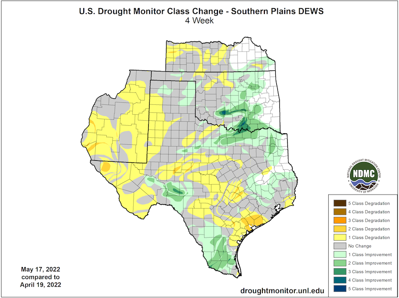
This map shows drought conditions across the Southern Plains Drought Early Warning System as of May 17, 2022.
U.S. Drought Monitor Categories
The U.S. Drought Monitor is updated each Thursday to show the location and intensity of drought across the country. Drought categories show experts’ assessments of conditions related to dryness and drought including observations of how much water is available in streams, lakes, and soils compared to usual for the same time of year.
This map shows drought conditions across the Southern Plains Drought Early Warning System as of May 17, 2022.
Current Drought Conditions and Outlook
U.S. Drought Monitor Conditions
- 78% of the region is in drought (D1 or worse).
- 56% of the region is experiencing extreme (D3) to exceptional (D4) drought.
- Extreme (D3) drought conditions have been in place in this region since August 2019.
- The last time more than 50% of the Southern Plains region experienced D3 or greater drought was in January 2013.
- Moderate (D1) or worse drought has been in the region since June 2016.
Drought Change Over the Past Month
Recent and Forecast Precipitation
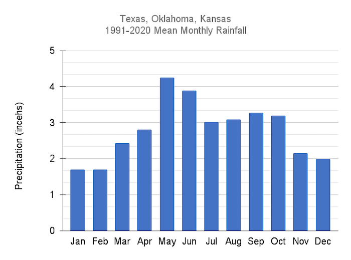
- May is usually the wettest month of the year for the Southern Plains.
- In an average year, the mean total precipitation for the Southern Plains states from January to the end of May is usually around 13 inches.
- Drought-affected areas of western Kansas, Oklahoma, Texas, and eastern New Mexico have received less than half the normal precipitation for this time in the year.
Mean Monthly Precipitation for Texas, Oklahoma, and Kansas
60-Day Percent of Normal Precipitation
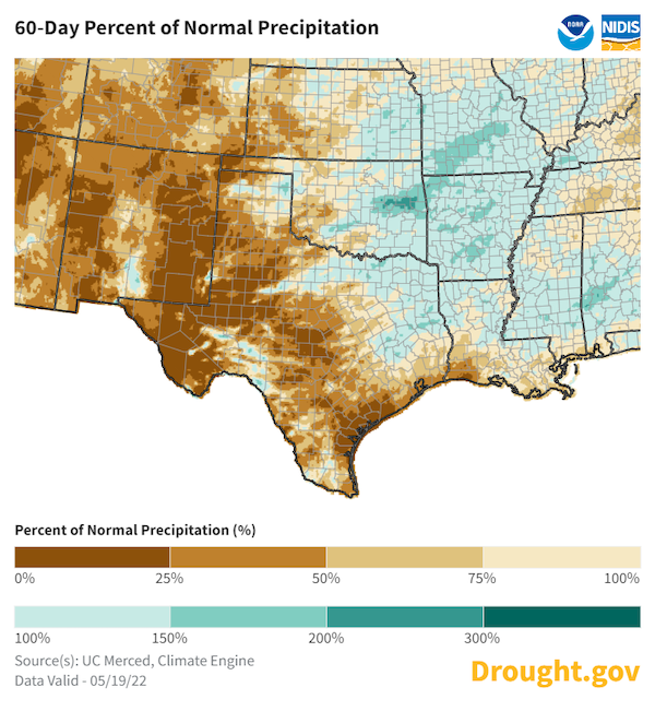
- April precipitation anomalies for the Southern Plains states:
- Texas: -1.08 inches
- Oklahoma: -0.83 inches
- Kansas: -1.55 inches, 3rd driest April on record
- New Mexico: -0.69 inches, 2nd driest April on record
- A few May storms have provided above-average precipitation for eastern Oklahoma where drought conditions have considerably improved. Drought-affected parts of western Kansas, Oklahoma, and Texas have had below-average precipitation for the month so far.
- Forecast precipitation across the Southern Plains could bring May precipitation in the Oklahoma and Texas panhandles to near-average for the month, with above-average precipitation in the eastern parts of those states.
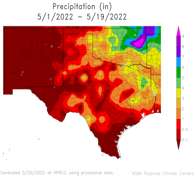
May Month-to-Date Total Precipitation
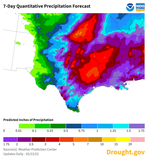
Quantitative Precipitation Forecast: May 23–30, 2022
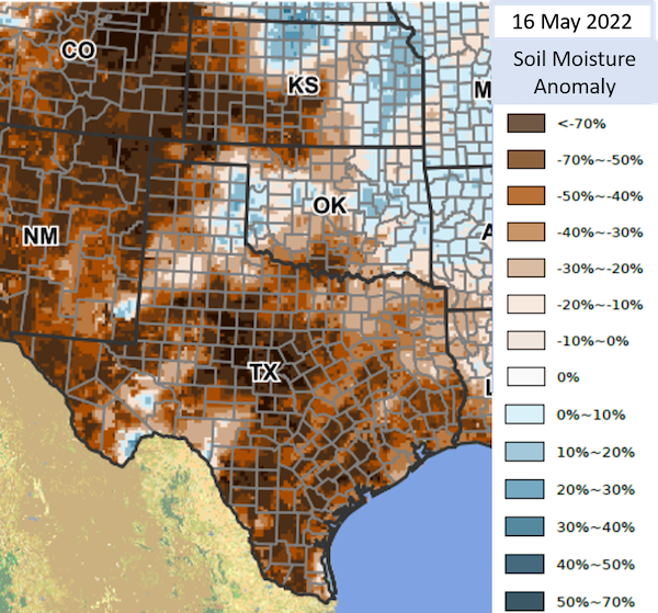
The USDA Crop Condition and Soil Moisture Analytics (Crop-CASMA) Product shows a significant shortage of soil moisture across the region.
Soil Moisture Anomaly for Mid-May
Forecasts and Seasonal Outlooks
June 2022
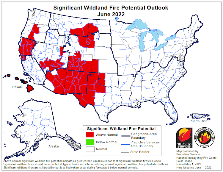
Fire risk is elevated for drought-stricken areas of the Southern Plains:
- Elevated fire risk is forecast to persist through at least June.
- Much of west Texas and the Texas Panhandle have Energy Release Components that are near or at record high values for this time of year.
Significant Wildland Fire Potential Outlook: June 2022
According to the Climate Prediction Center's monthly outlook for June:
- Odds favor increased temperatures across the whole Southern Plains region.
- Odds favor below-normal monthly precipitation for western Texas, Oklahoma, and Kansas, and eastern New Mexico.
June 2022 Temperature Outlook
June 2022 Precipitation Outlook
3-Month Outlook for June–August 2022
Seasonal forecasts show a hot and dry season ahead for the Southern Plains:
- Lower-than-normal precipitation is more likely than not for western Kansas, Oklahoma, Texas, and eastern New Mexico for June through August.
- Odds favor increased temperatures through the remainder of summer 2022 for the Southern Plains states.
Three-Month Temperature Outlook: June–August 2022
Three-Month Precipitation Outlook: June–August 2022
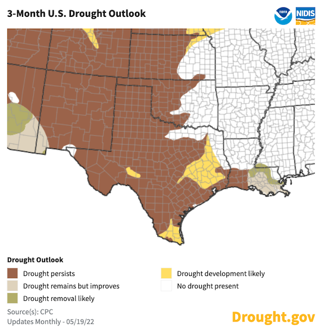
Seasonal Drought Outlook
- Drought is expected to continue for the western Southern Plains through summer.
- The Climate Prediction Center's 3-month drought outlook shows drought expanding in southern and eastern Texas.
May 19–August 30, 2022 Drought Outlook
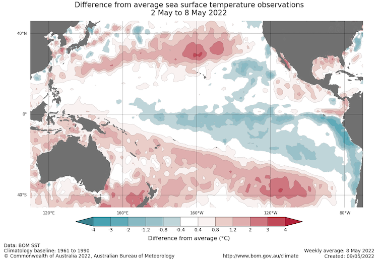
La Niña Persists and May Impact Winter Weather
- One of the primary drivers of drought across the Southwest, including western Texas, through winter and spring was a La Niña pattern in the Pacific.
- The May 16 weekly NINO3.4 value was −1.1 °C, indicating a La Niña pattern persists in the central Pacific.
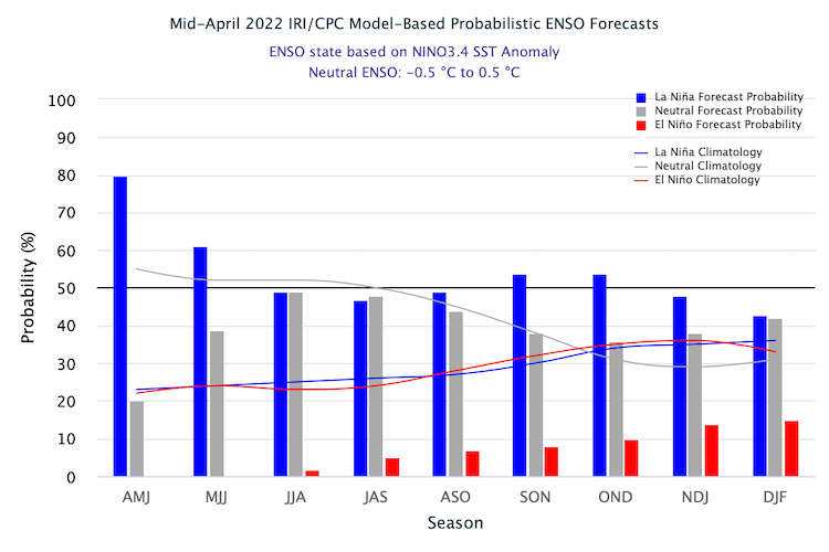
- La Niña patterns do not usually persist into northern-hemisphere summer months, but the few historical events that have persisted experienced decreased precipitation across the Southern Plains in early summer and no strong pattern in late summer. No two La Niña patterns are the same.
- The latest forecasts for winter 2022–23 indicate that another La Niña is slightly more likely to occur than a neutral pattern this winter, and an El Niño is unlikely. This means another dry winter is possible for the Southern Plains.
- For more information, please check out the NOAA El Niño–Southern Oscillation (ENSO) blog.
Sea Surface Temperature Anomalies (°C) for May 2–8, 2022
Probability of El Niño, La Niña, or Neutral Conditions
State-Based Conditions and Impacts
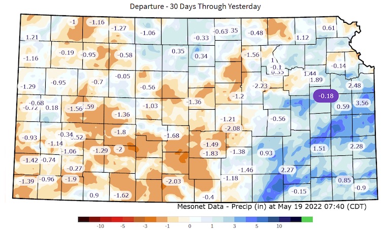
Kansas
- Anticipated low wheat yields due to early slow development with cooler/drier conditions and now maturing too quickly with recent warmth.
- Continued early irrigation with concerns about water allocations being reached early in the season.
- Several wildfires have occurred in the southwest, including lightning starts. May fires and natural ignitions are rare for Kansas.
- Continued cattle sell-offs due to limited surface water and poor forage conditions.
30-Day Departure from Normal Precipitation
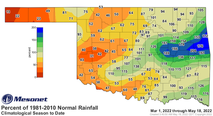
Oklahoma
- Rains through spring have relieved drought across much of eastern Oklahoma.
- Prolonged deficits have proven difficult to overcome across the western one-half of Oklahoma, leading to drought persistence.
- Oklahoma's winter wheat abandonment is expected to be more than 45% of the planted crop (2.0 million acres out of the 4.4 million planted), with the yield at 25 bushels/acre, a 35.9% drop from last year.
Percent of Normal Rainfall: March 1–May 18
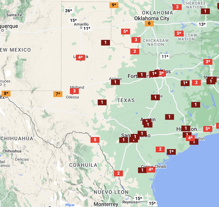
Texas
- Statewide average rainfall was less than 10 inches for the period September–April. This is sixth driest on record and the driest since1925, almost one hundred years ago.
- The first 20 days of May were the warmest on record for large portions of the state:
- Through May 20, Houston, Austin, San Antonio, and the Dallas-Fort Worth area were all experiencing record warm temperatures for the month of May.
- Prior to this year, in Abilene, the greatest number of 100 °F temperatures in the month of May was 7. May 20 marked the 12th day this month where Abilene experienced 100 °F temperatures.
- A cold front late on Saturday, May 21 is expected to provide temporary relief from the heat for all but South Texas. The wet pattern may also improve drought conditions, but it is too late for most of the winter wheat crop and much of the spring plantings.
Average Temperature Rankings: May 1–17
New Mexico
- Statewide, April 2022 tied April 1991 as the second driest April on record with only 0.06 inches of precipitation, all of which was confined to the northern counties. April 2022 was also the 11th warmest April on record and the warmest since 2012.
- With over 311,000 acres burned, the Hermits Peak/Calf Canyon Fire Complex is now the largest in modern records for the state of New Mexico.
- As of May 19, reservoir storage along the Rio Grande and Pecos River Basins are very low. Along the Rio Grande, Elephant Butte is at 13% full, and Caballo is at 14% full. On the Pecos River, Sumner is at 32%, Brantley is at 46%, and Avalon is at 20%.
For More Information
NIDIS and its partners will issue future drought updates as conditions evolve.
More local information is available from the following resources:
In Case You Missed It
- April 27, 2022: Texas Drought Status Webinar
- May 11, 2022: Oklahoma Drought Status Webinar
Upcoming Events
- June 2, 2022: Drought Update and Wildfire Outlook Webinar for California and the Southwest
- June 7–8, 2022, Las Cruces, New Mexico: Southwest Drought Learning Network Annual Meeting
- August 2–3, 2022, Norman, Oklahoma: Southern Plains Drought Early Warning System Partners Meeting
Prepared By
Joel Lisonbee
NOAA/National Integrated Drought Information System (NIDIS), Southern Plains Drought Early Warning System and CIRES/CU Boulder
Gary McManus
Oklahoma State Climatologist, Oklahoma Mesonet, Oklahoma Climatological Survey
Chip Redmond
Kansas State University
John Nielsen-Gammon
Texas State Climatologist, Texas A&M University
Victor Murphy
National Weather Service
This drought early warning update is issued in partnership between the National Oceanic and Atmospheric Administration (NOAA) and the offices of the state climatologist for Texas, Oklahoma, New Mexico, and Kansas. The purpose of the update is to communicate a potential area of concern for drought expansion and/or development within the Southern Plains based on recent conditions and the upcoming forecast. NIDIS and its partners will issue future drought updates as conditions evolve.