Extreme Heat and No Rain Has Sparked Flash Drought in the Southern Plains.
Key Points
- An extreme and record-setting heat wave coupled with very low precipitation has caused a rapid intensification of drought over the Southern Plains.
- June and July precipitation has been in the lowest 20% of historical records.
- There are reports of cattle producers selling livestock to adapt to poor grazing conditions and high feed prices.
Current Drought Conditions and Outlook
Persistent Dry Conditions and Heat Wave
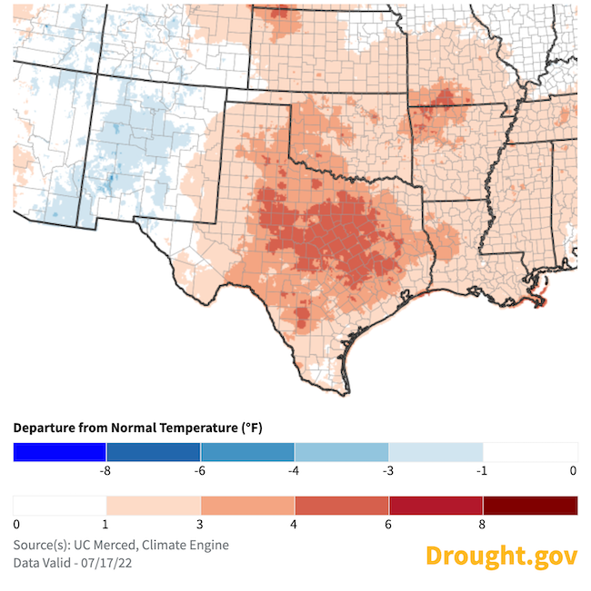
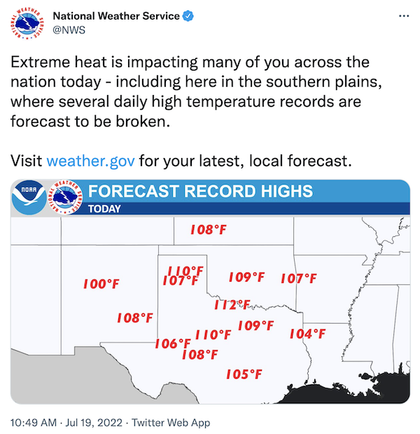
- An intense heat wave has settled over Texas and Oklahoma.
- Maximum temperatures:
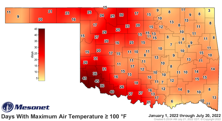
- Parts of southern Oklahoma and northern Texas have already had over 40 days above 100 ºF this year.
- The highest temperature so far this year in Texas occurred on June 8, 2022, at Rio Grande Village in Brewster County. The temperature hit 117 ºF.
- On July 19, 2022, all Oklahoma Mesonet sites reached 103 ºF or higher on the same day—a first for the network of 120 sites, which has records back to the mid-1990s.
- From June 1 to July 18, 2022, a combined 27 monthly record-high maximum temperatures have been either tied or broken in Texas, Oklahoma, Kansas, and New Mexico.
- Minimum temperatures:
- From June 1 to July 18, 2022, a combined 80 monthly record-high minimum temperatures have been either tied or broken in Texas, Oklahoma, Kansas, and New Mexico.
- On July 18, the daily minimum temperature of 86 ºF tied the all-time record-high minimum temperature at Dallas-Fort Worth International Airport.
- Maximum temperatures:
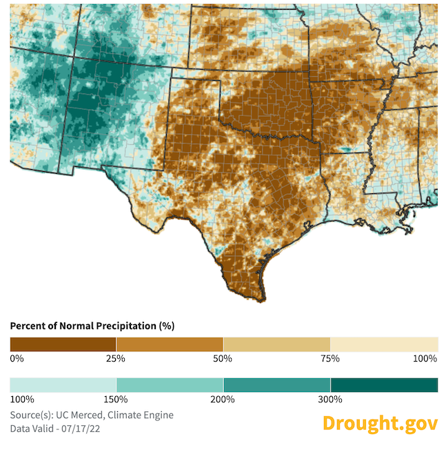
- Precipitation has been less than 25% of normal for this time of year.
- A large area in eastern Oklahoma and a few pockets of northern Texas have had less than 0.1 inches of precipitation over the last 30 days.
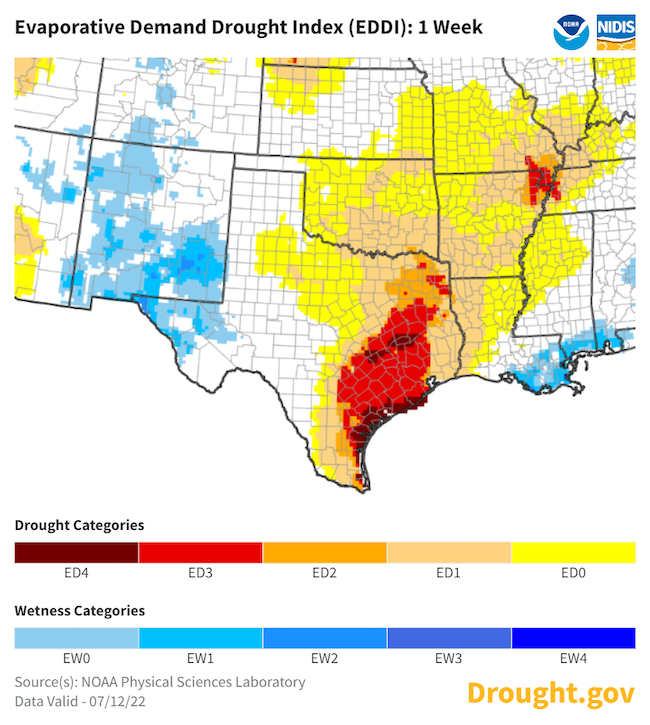
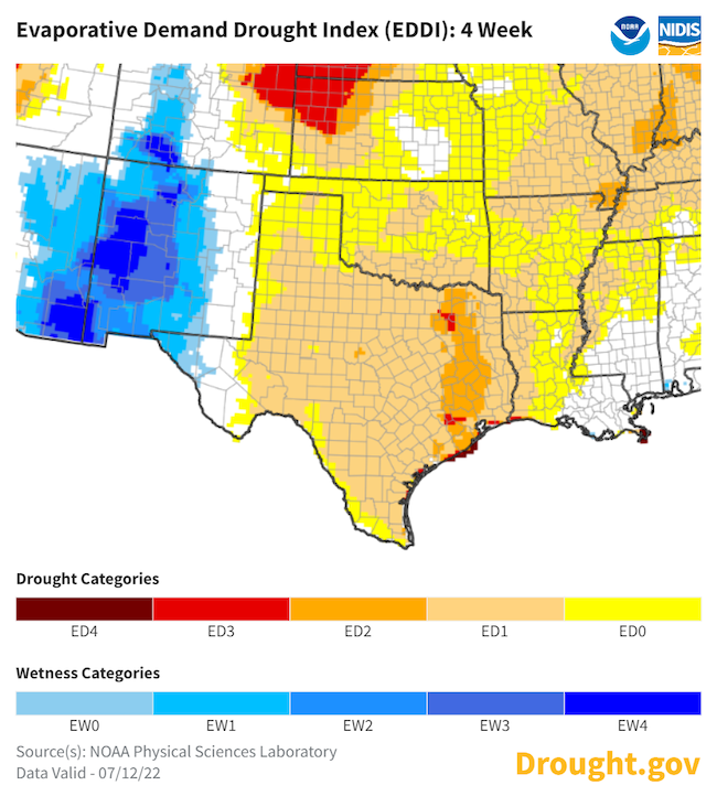
- Evaporative demand has been persistently high for the last 4 weeks, including very high Evaporative Demand Drought Index values over the past week. What little water may have entered the landscape has quickly evaporated.
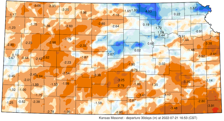
30-Day Departure from Normal Temperature
30-Day Percent of Normal Precipitation
Rapid Drought Intensification ("Flash Drought")
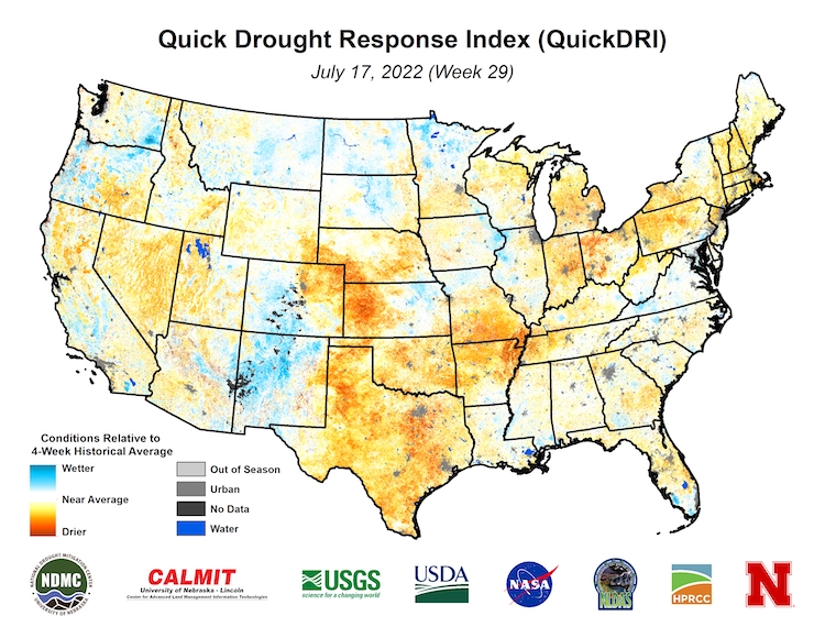
- Low precipitation with intense heat waves can rapidly intensify drought conditions.
- The Quick Drought Response Index (QuickDRI) for the 4 weeks leading up to July 17 shows a rapidly developing drought across western Kansas, Oklahoma, Texas, southern Missouri, and northern Arkansas.
U.S. Drought Monitor Conditions
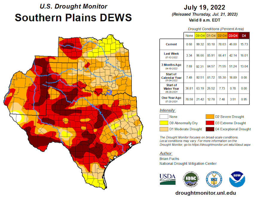
- 93% of the region is in drought (D1 or worse).
- 46% of the region is experiencing extreme (D3) to exceptional (D4) drought.
- Extreme (D3) drought conditions have been in place in this region since August 2019.
- Moderate (D1) or worse drought has been in the region since June 2016.
Forecasts and Seasonal Outlooks
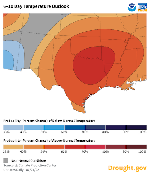
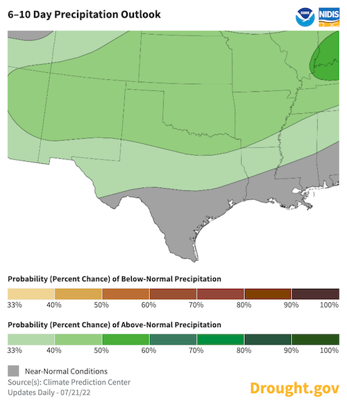
Late July 2022: 6–10 Day Outlook
Hot conditions are forecast to remain through July. A rain-bearing cold front is expected in the short-range outlook, but there is uncertainty about how much rain it will produce and how far south it will dip.
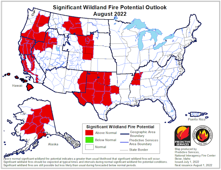
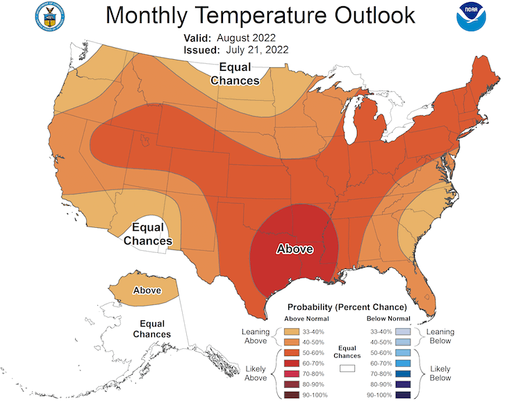
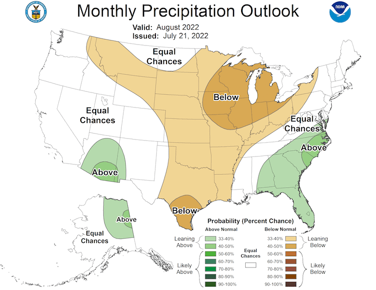
August 2022 Outlook
- Fire risk is elevated for drought-stricken areas of the Southern Plains
- Significant wildland fire potential remains elevated over western Oklahoma and Texas through August.
According to the Climate Prediction Center's monthly outlook for August:
- Increased temperatures are highly likely across the whole Southern Plains region with the highest odds over northeast New Mexico.
- Odds favor below-normal monthly precipitation for all but far-western Texas and the Oklahoma panhandle, where odds equally favor above- or below-normal precipitation.
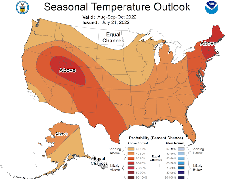
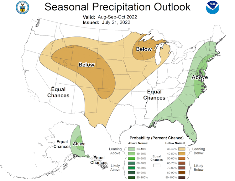
3-Month Outlook for August–October 2022
- Seasonal forecasts for August–October show a hotter-than-normal season ahead for the Southern Plains.
- Lower-than-normal precipitation is more likely for Kansas, Oklahoma, northern and western Texas, and eastern New Mexico.
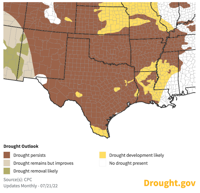
Seasonal Drought Outlook for July 21–October 31
With persistent high temperatures and low precipitation in the Climate Prediction Center's seasonal outlook, areas that are already in drought are expected to remain in drought while drought development is likely over Louisiana and southern Arkansas.
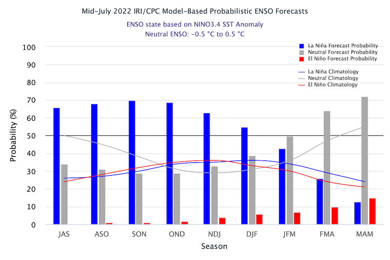
La Niña Persists and May Impact Winter Weather
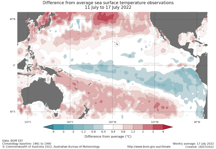
- One of the primary drivers of drought across the Southwest, including western Texas, through winter and spring was a La Niña pattern in the Pacific.
- The July 18 weekly NINO3.4 value was −0.6 °C. This is marginally within the La Niña threshold.
- The latest Climate Prediction Center El Niño–Southern Oscillation (ENSO) discussion maintains a La Niña Advisory. La Niña is favored to continue through 2022, with the odds for La Niña decreasing into the Northern Hemisphere late summer (60% chance in July–September 2022) before increasing through the Northern Hemisphere fall and early winter 2022 (62%–66% chance).
- La Niña patterns do not usually persist into Northern Hemisphere summer months, but the few historical events that have persisted experienced decreased precipitation in northern Texas in the summer with no strong pattern through the rest of the region.
- The latest forecasts for winter 2022–23 indicate that another La Niña is slightly more likely to occur than a neutral pattern this winter, and an El Niño is unlikely.
- A third La Niña pattern in winter would favor another dry winter ahead for the Southern Plains and the Southwest U.S. (learn more).
- No two La Niña patterns are the same. For more information, please check out the NOAA ENSO blog.
Sea Surface Temperature Anomalies (°C) for May 30–June 5, 2022
Probability of El Niño, La Niña, or Neutral Conditions
State-Based Conditions and Impacts
Kansas
- Through July, the whole state has been dealing with 100–105 degree temperatures—already more in one month than would be expected for the entire year for some locations.
- In western Kansas, sorghum—a highly drought-tolerant crop—is very stressed.
- The state has seen a large number of dry lightning fires. Grass fires are not typically this widespread, especially in the southeast.
- Goodland, Kansas has issued a Water Watch, encouraging voluntary reductions in water use.
- In mid-June, days of intense heat have killed thousands of cattle in Kansas.
- To learn more, read the June Climate Summary for Kansas.
Oklahoma
- A flash drought (rapid intensification of drought conditions) is developing over eastern Oklahoma.
- Oklahoma has been in a pattern of repeated and intense heat waves and little-to-no rain caused by a persistent high-pressure pattern.
- On July 19, 2022, all Oklahoma Mesonet sites reached 103 ºF or higher on the same day—a first for the network of 120 sites, which has records back to the mid-1990s.
- Oklahoma’s drought-impacted winter wheat harvest estimates are down to 72.9 million bushels, according to the USDA. This is down 37% from last year and would be the state’s lowest production total since 2014.

Texas
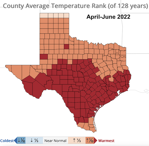
- The statewide average temperature for June 2022 was 83.8 °F, ranking fifth warmest overall and 4.2 °F above the 20th-century average. July so far is on track to be the second hottest on record, behind only 2011.
- Year-to-date statewide average rainfall is 7.91 inches as of June 30, 2022. This is the sixth driest January–June on record and the driest since 2011.
- Wildfire risk continues to increase across the state as shrubs and trees dry out and dead leaves and grasses provide fuel for fire ignition.
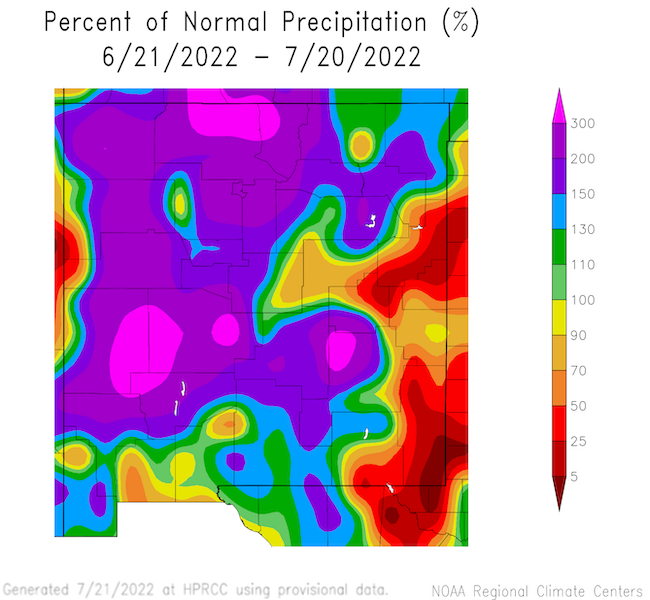
New Mexico
- Spring 2022 (March-April-May) was the 6th driest spring on record for New Mexico with 0.76 inches of precipitation.
- June is usually a relatively dry month for New Mexico. June 2022 precipitation, when averaged across the state, was the 5th wettest on record, bolstered by an early onset of the Southwest Monsoon.
- Western New Mexico benefited from most of the early monsoon rain while the eastern part of the state mostly missed out.
For More Information
NIDIS and its partners will issue future drought updates as conditions evolve.
More local information is available from the following resources:
In Case You Missed It
- July 21, 2022: 2022 U.S. Drought and Heat Webinar: The Southern Plains
Upcoming Events
- August 2–3, 2022, Norman, Oklahoma: Southern Plains Drought Early Warning System Partners Meeting
Prepared By
Joel Lisonbee
NOAA/National Integrated Drought Information System (NIDIS), Southern Plains Drought Early Warning System and CIRES/CU Boulder
Gary McManus
Oklahoma State Climatologist, Oklahoma Mesonet, Oklahoma Climatological Survey
Chip Redmond
Kansas State University
John Nielsen-Gammon
Texas State Climatologist, Texas A&M University
Southern Regional Climate Center
Victor Murphy
National Weather Service
This drought status update is issued in partnership between the National Oceanic and Atmospheric Administration (NOAA) and the offices of the state climatologist for Texas, Oklahoma, New Mexico, and Kansas. The purpose of the update is to communicate a potential area of concern for drought expansion and/or development within the Southern Plains based on recent conditions and the upcoming forecast. NIDIS and its partners will issue future drought updates as conditions evolve.
